Name Metres Feet Location Island Coordinate Last eruption Água de Pau (Fogo) 947 3,107 Serra de Água de Pau São Miguel 37°45′44″N 25°28′25″W / 37.76222°N 25.47361°W / 37.76222; -25.47361 (Agua de Pau ) 1564 Cabeço do Caveiro 1061 3,481 Achada Plateau Pico 38°26′27″N 28°12′52″W / 38.44083°N 28.21444°W / 38.44083; -28.21444 (Cabeco do Caveiro ) — Cabeço dos Grotões 987 3,238 Achada Plateau Pico 38°26′27″N 28°12′52″W / 38.44083°N 28.21444°W / 38.44083; -28.21444 (Cabeco dos Grotoes ) — Caldeirão 718 2,356 Morro dos Homens Corvo 39°42′37″N 31°6′39″W / 39.71028°N 31.11083°W / 39.71028; -31.11083 (Caldeiro ) — Dom João de Castro Bank -43 −141 Atlantic Ocean - 38°13′47″N 26°37′48″W / 38.22972°N 26.63000°W / 38.22972; -26.63000 (Dom Joao de Castro Bank ) 1720 Sete Cidades 856 2,808 Sete Cidades Massif São Miguel 37°52′11″N 25°46′48″W / 37.86972°N 25.78000°W / 37.86972; -25.78000 (Sete Cidades (Ponta Delgada) ) 1880 Pico das Éguas 874 2,867 Sete Cidades Massif São Miguel 37°49′46″N 25°45′18″W / 37.82944°N 25.75500°W / 37.82944; -25.75500 (Pico das Equas ) — Serra Gorda 485 1,591 Picos Fissural Region São Miguel 37°47′20″N 25°40′59″W / 37.78889°N 25.68306°W / 37.78889; -25.68306 (Serra Gorda ) -5000 Congro 560 1,840 Achada das Furnas São Miguel 37°45′22″N 25°24′25″W / 37.75611°N 25.40694°W / 37.75611; -25.40694 (Sao Miguel Island ) -3400 Furnas 804 2,638 Achada das Furnas São Miguel 37°46′11″N 25°19′12″W / 37.76972°N 25.32000°W / 37.76972; -25.32000 (Furnas (Povoacao) ) 1630 Santa Bárbara 1021 3,350 Mistério Negros Terceira 38°43′47″N 27°19′11″W / 38.72972°N 27.31972°W / 38.72972; -27.31972 (Serra de Santa Barbara ) 1761 Pico Alto 808 2,651 - Terceira 38°45′20″N 27°12′36″W / 38.75556°N 27.21000°W / 38.75556; -27.21000 (Pico Alto ) -1000 Pico da Esperança 1053 3,455 Manadas Fissural Volcanic System São Jorge 38°39′2″N 28°4′27″W / 38.65056°N 28.07417°W / 38.65056; -28.07417 (Pico da Esperanca ) 1907 Caldeira 402 1,319 - Graciosa 39°1′29″N 27°58′19″W / 39.02472°N 27.97194°W / 39.02472; -27.97194 (Graciosa Island ) -10000 Pico 2351 7,713 - Pico 38°28′19″N 28°21′50″W / 38.47194°N 28.36389°W / 38.47194; -28.36389 (Mount Pico ) 1718 Capelinhos 755 2,477 Costa de Nau Faial 38°36′6″N 28°49′57″W / 38.60167°N 28.83250°W / 38.60167; -28.83250 (Capelinhos ) 1958 Caldeira Volcano 1043 3,422 Cabeço Gordo Faial 38°35′9″N 28°42′50″W / 38.58583°N 28.71389°W / 38.58583; -28.71389 (Cabeco Gordo ) 1958 S.V. Serreta 300 980 Atlantic Ocean - 38°47′06″N 27°27′00″W / 38.78500°N 27.45000°W / 38.78500; -27.45000 (S.V.Serreta ) 2001 S.V. Velas -32 −105 Atlantic Ocean - 38°42′30″N 28°17′08″W / 38.70833°N 28.28556°W / 38.70833; -28.28556 (S.V.Velas ) 1964 S.V. Cachorro -130 −430 Atlantic Ocean - 38°35′32″N 28°29′32″W / 38.59222°N 28.49222°W / 38.59222; -28.49222 1963 Monaco Bank -197 −646 Atlantic Ocean - 37°36′02″N 25°51′59″W / 37.60056°N 25.86639°W / 37.60056; -25.86639 (Monaco Bank ) 1911 S.V. Sabrina -26 −85 Atlantic Ocean - 37°51′09″N 25°52′18″W / 37.85250°N 25.87167°W / 37.85250; -25.87167 (Sabrina Island ) 1811 Topo 1002 3,287 Lajes do Pico Pico 38°25′21″N 28°13′34″W / 38.42250°N 28.22611°W / 38.42250; -28.22611 (Topo ) -5000 Urzelina 900 3,000 Mato da Urzelina São Jorge 38°40′03″N 28°07′19″W / 38.66750°N 28.12194°W / 38.66750; -28.12194 (Urzelina ) 1808 Pico Vermelho 937 3,074 Fissural Zone Terceira 38°44′07″N 27°16′48″W / 38.73528°N 27.28000°W / 38.73528; -27.28000 (Terceira Island ) 1761 Cabeços do Fogo 445 1,460 Fissural Zone Pico 38°25′57″N 28°18′27″W / 38.43250°N 28.30750°W / 38.43250; -28.30750 (Cabecos do Fogo ) 1720 S.V. Hirondella -2665 −8,743 Atlantic Ocean - 38°07′02″N 26°07′59″W / 38.11722°N 26.13306°W / 38.11722; -26.13306 (S.V.Hirondella ) 1682 Cabeço do Fogo 104 341 Capelo Faial 38°35′11″N 28°46′8″W / 38.58639°N 28.76889°W / 38.58639; -28.76889 (Cabeco do Fogo ) 1672 Picarito 430 1,410 Capelo Faial 38°35′11″N 28°46′8″W / 38.58639°N 28.76889°W / 38.58639; -28.76889 (Picarito ) 1673 Pico do Fogo 275 902 Fissural Zone São Miguel 37°46′32″N 25°34′56″W / 37.77556°N 25.58222°W / 37.77556; -25.58222 (Pico do Fogo ) 1652 S.V. Candelária -115 −377 Ponta da Candelária São Miguel 37°49′34″N 25°52′26″W / 37.82611°N 25.87389°W / 37.82611; -25.87389 (S.v.Candelaria ) 1638 Lagoa Seca 375 1,230 Furnas São Miguel 37°44′34″N 25°19′33″W / 37.74278°N 25.32583°W / 37.74278; -25.32583 (Lagoa Seca ) 1630 Mistério da Queimada 264 866 Fissual Zones Manadas São Jorge 38°40′45″N 28°11′25″W / 38.67917°N 28.19028°W / 38.67917; -28.19028 (Misterio da Queimada ) 1580 Pico do Sapateiro (Pico Queimado) 348 1,142 Serra de Água de Paul São Miguel 37°47′07″N 25°32′37″W / 37.78528°N 25.54361°W / 37.78528; -25.54361 (Pico do Sapateiro ) 1563 Cabeços do Mistério 816 2,677 Fissural Zone Pico 38°28′04″N 28°16′20″W / 38.46778°N 28.27222°W / 38.46778; -28.27222 (Cabecos do Misterio ) 1564 Pico do Gaspar 361 1,184 Achada das Furnas São Miguel 37°45′31″N 25°18′58″W / 37.75861°N 25.31611°W / 37.75861; -25.31611 (Pico do Gaspar ) 1443  The largest volcano in the Azores: Mount Pico
 A series of cones toward the Caldeira on Faial
 The shield volcano of Santa Bárbara on Terceira
 Pico do Gaspar, a spatter cone on Terceira


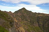 The tallest volcanic peak of Madeira, Pico Ruivo
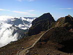 A cloud layer around Pico das Torres
 Looking towards the summit of Pico do Arieiro

