Liverpool is a city and port in Merseyside, England, which contains many listed buildings. A listed building is a structure designated by English Heritage of being of architectural and/or of historical importance and, as such, is included in the National Heritage List for England. There are three grades of listing, according to the degree of importance of the structure. Grade I includes those buildings that are of "exceptional interest, sometimes considered to be internationally important"; the buildings in Grade II* are "particularly important buildings of more than special interest"; and those in Grade II are "nationally important and of special interest". Very few buildings are included in Grade I — only 2.5% of the total. Grade II* buildings represent 5.5% of the total, while the great majority, 92%, are included in Grade II.
Saughall is a former civil parish now in the parishes of Saughall and Shotwick Park, Puddington and the unparished area of Chester, in Cheshire West and Chester, England. It contains eleven buildings that are recorded in the National Heritage List for England as designated listed buildings, all of which are listed at Grade II. This grade is the lowest of the three gradings given to listed buildings and is applied to "buildings of national importance and special interest". The parish contains the village of Saughall, and is otherwise rural. Most of the listed buildings are houses and associated structures. The others include a former inn, a former windmill, a church, and two guideposts.

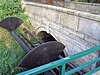
Arrowe Brook is a tributary of The Birket, in Wirral, Merseyside. The river starts as lowland field drainage around Irby, Thingwall and Landican. The brook flows through Arrowe Park, Upton Meadow and Greasby, before Greasby Brook converges between Greasby and Saughall Massie. Arrowe Brook then goes beneath Saughall Massie bridge. This was the first bridge constructed by the notable Victorian civil engineer Sir Thomas Brassey, in 1829. The bridge was awarded Grade II listed status by English Heritage, in 2007. The brook then continues, to join the Birket at Moreton. The Birket, in turn, discharges into the West Float at the site of the former Wallasey Pool.
Lea is a civil parish in Lancashire, England. It contains 12 buildings that are recorded in the National Heritage List for England as designated listed buildings. Of these, one is listed at Grade I, the highest of the three grades, and all the others are at Grade II. The parish is partly residential, but mainly rural, and the Lancaster Canal runs through it. Four bridges crossing the canal are listed, the other listed buildings being houses, farmhouses and associated structures, and a cross that probably has a medieval origin.
Rainhill is a civil parish in St Helens, Merseyside, England. It contains 19 buildings that are recorded in the National Heritage List for England as designated listed buildings. Of these, two are listed at Grade II*, the middle of the three grades, and the others are at Grade II, the lowest grade. The parish was originally rural, and within it was a coaching stop on the turnpike road between Liverpool and Warrington. Following the arrival of the Liverpool and Manchester Railway in the 1830s, the settlements of Rainhill and Rainhill Stoops grew, and merged to become a dormitory residential area. The listed buildings include farmhouses and farm buildings, and large houses that have been converted for later uses. Associated with the railway are its skew bridge and the station. The other listed buildings include churches, a school, an ancient cross, and a water tower.
Whiston is a civil parish in Knowsley, Merseyside, England. It contains nine buildings that are recorded in the National Heritage List for England as designated listed buildings, all of which are listed at Grade II. This grade is the lowest of the three gradings given to listed buildings and is applied to "buildings of national importance and special interest". The parish is partly residential, and partly rural. The listed buildings include farmhouses and farm buildings, houses, structure sat the entrance to a former country house, a church, and a railway bridge.
Cronton is a civil parish in Knowsley, Merseyside, England. It contains eight buildings that are recorded in the National Heritage List for England as designated listed buildings, all of which are listed at Grade II. This grade is the lowest of the three gradings given to listed buildings and is applied to "buildings of national importance and special interest". The parish includes the village of Cronton, and is otherwise rural. Apart from a medieval cross base and a set of stocks, the listed buildings are all houses and associated structures.
Litherland is an area to the north of Liverpool in Sefton, Merseyside, England. It contains five buildings that are recorded in the National Heritage List for England as designated listed buildings, all of which are listed at Grade II. This grade is the lowest of the three gradings given to listed buildings and is applied to "buildings of national importance and special interest". The area is almost completely residential, and the listed buildings consist of two churches, a Methodist mission, a former Sunday school, and a farmhouse.
Little Altcar is a civil parish and a village in Sefton, Merseyside, England. It contains five buildings that are recorded in the National Heritage List for England as designated listed buildings, all of which are listed at Grade II. This grade is the lowest of the three gradings given to listed buildings and is applied to "buildings of national importance and special interest". Originally rural, the parish has been partly occupied by housing. The listed buildings are farmhouses and farm buildings.
Lydiate is a civil parish and a village in Sefton, Merseyside, England. It contains 14 buildings that are recorded in the National Heritage List for England as designated listed buildings. Of these, two are listed at Grade II*, the middle of the three grades, and the others are at Grade II, the lowest grade.
Bold is a civil parish in St Helens, Merseyside, England. It contains six buildings that are recorded in the National Heritage List for England as designated listed buildings, all of which are listed at Grade II. This grade is the lowest of the three gradings given to listed buildings and is applied to "buildings of national importance and special interest".
Eccleston is a civil parish in St Helens, Merseyside, England. It contains seven buildings that are recorded in the National Heritage List for England as designated listed buildings. Of these, four are listed at Grade II*, the middle of the three grades, and the others are at Grade II, the lowest grade.
Prenton is a suburb of Birkenhead, Wirral, Merseyside, England. It contains seven buildings that are recorded in the National Heritage List for England as designated listed buildings, all of which are listed at Grade II. This grade is the lowest of the three gradings given to listed buildings and is applied to "buildings of national importance and special interest". Originally a rural area, since the 1920s it has been developed for residential use. Four of the listed buildings are former farmhouses and farm buildings that have been adapted for other uses, and the others are a church and two war memorials.
Poulton is an area to the south of the town of Bebington, Wirral, Merseyside, England. It contains seven buildings that are recorded in the National Heritage List for England as designated listed buildings, all of which are listed at Grade II. This grade is the lowest of the three gradings given to listed buildings and is applied to "buildings of national importance and special interest". The listed buildings consist of farmhouses and farm buildings, a country house and associated buildings, and a pinfold.
Raby is a village in Wirral, Merseyside, England. It contains eight buildings that are recorded in the National Heritage List for England as designated listed buildings, all of which are listed at Grade II. This grade is the lowest of the three gradings given to listed buildings and is applied to "buildings of national importance and special interest". The listed buildings consist of farmhouses, farm buildings, cottages, and a public house.
Gayton is a village in Wirral, Merseyside, England. It contains four buildings that are recorded in the National Heritage List for England as designated listed buildings. Of these, two are listed at Grade II*, the middle of the three grades, and the others are at Grade II, the lowest grade. The listed buildings consist of a country house, a dovecote, a farmhouse, and a former windmill.
Irby is a village in Wirral, Merseyside, England. It contains three buildings that are recorded in the National Heritage List for England as designated listed buildings, all of which are listed at Grade II. This grade is the lowest of the three gradings given to listed buildings and is applied to "buildings of national importance and special interest". The listed buildings consist of two farmhouses and a country house.
Heswall is a town in Wirral, Merseyside, England. It contains nine buildings that are recorded in the National Heritage List for England as designated listed buildings. Of these, one is listed at Grade II*, the middle of the three grades, and the others are at Grade II, the lowest grade. The list includes those in the adjacent villages of Barnston, Thingwall and Pensby. The listed buildings consist of two churches, houses, a bank, a sundial, and a war memorial.
Wray-with-Botton is a civil parish in Lancaster, Lancashire, England. It contains 44 listed buildings that are recorded in the National Heritage List for England. All of the listed buildings are designated at Grade II, the lowest of the three grades, which is applied to "buildings of national importance and special interest". The parish contains the village of Wray, and is otherwise rural containing scattered farms. Apart from a bridge, all the listed buildings are houses, farmhouses, farm buildings, and structures associated with them.