
Lists of borders cover land and maritime borders between countries and territories.
Lists of borders cover land and maritime borders between countries and territories.
A territorial dispute or boundary dispute is a disagreement over the possession or control of land between two or more political entities.
Borders are geographical boundaries, imposed either by geographic features such as oceans, or by arbitrary groupings of political entities such as governments, sovereign states, federated states, and other subnational entities. Borders are established through warfare, colonization, or mutual agreements between the political entities that reside in those areas; the creation of these agreements is called boundary delimitation.
A tripoint, trijunction, triple point, or tri-border area is a geographical point at which the boundaries of three countries or subnational entities meet. There are approximately 176 international tripoints. Nearly half are situated in rivers, lakes or seas. On dry land, the exact tripoints may be indicated by markers or pillars, and occasionally by larger monuments.

Boundary Islet, historically known as North East Islet, is a two ha (4.9-acre) islet in the Hogan Island Group of Bass Strait, at a latitude of 39°12′ S, about 56 km (35 mi) east of the southernmost point of mainland Victoria. The islet straddles the maritime border of the Australian states of Victoria and Tasmania, hence the name.
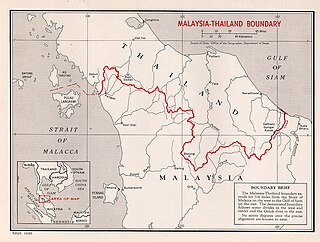
The Malaysia–Thailand border divides the countries of Malaysia and Thailand and consists of a land boundary running for 595 km (370 mi) across the Malay Peninsula and maritime boundaries in the Straits of Malacca and the Gulf of Thailand/South China Sea. The Golok River forms the easternmost 95 km stretch of the land border.

The history of post-confederation Canada began on July 1, 1867, when the British North American colonies of Canada, New Brunswick, and Nova Scotia were united to form a single Dominion within the British Empire. Upon Confederation, the United Province of Canada was immediately split into the provinces of Ontario and Quebec. The colonies of Prince Edward Island and British Columbia joined shortly after, and Canada acquired the vast expanse of the continent controlled by the Hudson's Bay Company, which was eventually divided into new territories and provinces. Canada evolved into a fully sovereign state by 1982.

Peru v Chile is a public international law case concerning a territorial dispute between the South American republics of Peru and Chile over the sovereignty of an area at sea in the Pacific Ocean approximately 37,900 square kilometres (14,600 sq mi) in size. Peru contended that its maritime boundary delimitation with Chile was not fixed, but Chile claimed that it holds no outstanding border issues with Peru. On January 16, 2008, Peru brought forth the case to the International Court of Justice at The Hague, the Netherlands, which accepted the case and formally filed it as the Case concerning maritime delimitation between the Republic of Peru and the Republic of Chile - Perú v. Chile.
While the United States has relatively complicated maritime boundaries, it shares international land borders with only two nations:
Boundary delimitation is the drawing of boundaries, particularly of electoral precincts, states, counties or other municipalities. In the context of elections, it can be called redistribution and is used to prevent unbalance of population across districts. In the United States, it is called redistricting. Unbalanced or discriminatory delimitation is called "gerrymandering." Though there are no internationally agreed processes that guarantee fair delimitation, several organizations, such as the Commonwealth Secretariat, the European Union and the International Foundation for Electoral Systems have proposed guidelines for effective delimitation.
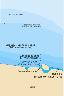
A maritime boundary is a conceptual division of the Earth's water surface areas using physiographic or geopolitical criteria. As such, it usually bounds areas of exclusive national rights over mineral and biological resources, encompassing maritime features, limits and zones. Generally, a maritime boundary is delineated at a particular distance from a jurisdiction's coastline. Although in some countries the term maritime boundary represents borders of a maritime nation that are recognized by the United Nations Convention on the Law of the Sea, maritime borders usually serve to identify the edge of international waters.
India shares borders with several sovereign countries; it shares land borders with China, Bhutan, Nepal, Pakistan, Bangladesh and Myanmar. Bangladesh and Pakistan share both land borders as well as maritime borders, while Sri Lanka shares only a maritime border though Ram setu. India's Andaman and Nicobar Islands share a maritime border with Thailand, Myanmar and Indonesia.

The exclusive economic zone of North Korea stretches 200 nautical miles from its basepoints in both the Yellow Sea and the Sea of Japan. The exclusive economic zone (EEZ) was declared in 1977 after North Korea had contested the validity of the Northern Limit Lines (NLL) set up after the Korean War as maritime borders. The EEZ has not been codified in law and North Korea has never specified its coordinates, making it difficult to determine its specific scope.
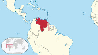
The borders of Venezuela are the international borders that Venezuela shares with neighboring countries. Venezuela borders with 14 countries totaling 5,161 kilometers which includes territories of France, the Kingdom of the Netherlands, the United Kingdom (Montserrat) and the United States. Venezuela has the seventh largest land and maritime border after France, China, the United Kingdom, Russia, the United States and Italy.