Great Britain
In Great Britain roads are numbered according to a zonal scheme:
These are lists of roads in the United Kingdom .
In Great Britain roads are numbered according to a zonal scheme:
The United Kingdom of Great Britain and Northern Ireland, commonly known as the United Kingdom (UK) or Britain, is a country in Northwestern Europe, off the coast of the continental mainland. It comprises England, Scotland, Wales, and Northern Ireland. The UK includes the island of Great Britain, the north-eastern part of the island of Ireland, and most of the smaller islands within the British Isles. Northern Ireland shares a land border with the Republic of Ireland; otherwise, the United Kingdom is surrounded by the Atlantic Ocean, the North Sea, the English Channel, the Celtic Sea, and the Irish Sea. The total area of the United Kingdom is 94,354 square miles (244,376 km2), with an estimated population of nearly 67.6 million people in 2022.
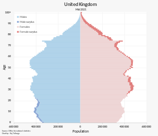
The population of the United Kingdom was estimated at almost 67.6 million people in 2022. It is the 21st most populated country in the world and has a population density of 279 people per square kilometre, with England having significantly greater density than Wales, Scotland, and Northern Ireland. Almost a third of the population lives in south east England, which is predominantly urban and suburban, with 8.9 million in the capital city, London, whose population density was 5,640 inhabitants per square kilometre (14,600/sq mi) in 2022.

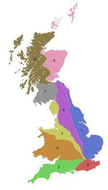
In Great Britain, there is a numbering scheme used to classify and identify all roads. Each road is given a single letter and a subsequent number. Though this scheme was introduced merely to simplify funding allocations, it soon became used on maps and as a method of navigation. There are two sub-schemes in use: one for motorways, and another for non-motorway roads.

Tourism in the United Kingdom is a major industry and contributor to the U.K. economy, which is the world's 10th biggest tourist destination, with over 40.1 million visiting in 2019, contributing a total of £234 billion to the GDP.

During British Summer Time (BST), civil time in the United Kingdom is advanced one hour forward of Greenwich Mean Time (GMT), in effect changing the time zone from UTC±00:00 to UTC+01:00, so that mornings have one hour less daylight, and evenings one hour more.
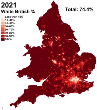
White British is an ethnicity classification used for the indigenous White population identifying as English, Scottish, Welsh, Cornish, Northern Irish, or British in the United Kingdom Census. In the 2011 census, the White British population was 49,997,686, 81.5% of Great Britain's total population. For the United Kingdom entirely, due to different reporting measures within Northern Ireland which includes all those who identified as British with those who identified as Irish, an amalgamated total of 52,320,080 including those who identified as White Irish in Great Britain is given making up 82.8% of the population.

Since 1922, the United Kingdom has been made up of four countries: England, Scotland, Wales and Northern Ireland. The UK Prime Minister's website has used the phrase "countries within a country" to describe the United Kingdom.
Ireland uses Irish Standard Time in the summer months and Greenwich Mean Time in the winter period.
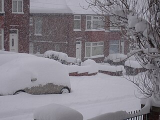
The winter of 2010–11 was a weather event that brought heavy snowfalls, record low temperatures, travel chaos and school disruption to the islands of Great Britain and Ireland. It included the United Kingdom's coldest December since Met Office records began, with a mean temperature of −1 °C (30 °F), breaking the previous record of 0.1 °C (32.2 °F) in December 1981. It was also the second coldest December in the narrower Central England Temperature (CET) record series which began in 1659, falling 0.1 °C short of the all-time record set in 1890. Although data has never officially been compiled, December 2010 is thought to be colder than December 1890 over the United Kingdom as a whole, as Scotland was up to 2 °C warmer than England. Hence, it is thought to be the coldest December across Great Britain since before 1659.

Since 1998, Northern Ireland has devolved government within the United Kingdom. The government and Parliament of the United Kingdom are responsible for reserved and excepted matters. Reserved matters are a list of policy areas, which the Westminster Parliament may devolve to the Northern Ireland Assembly at some time in future. Excepted matters are never expected to be considered for devolution. On all other matters, the Northern Ireland Executive together with the 90-member Northern Ireland Assembly may legislate and govern for Northern Ireland. Additionally, devolution in Northern Ireland is dependent upon participation by members of the Northern Ireland Executive in the North/South Ministerial Council, which co-ordinates areas of co-operation between Northern Ireland and the Republic of Ireland.