Chûn Castle is a large Iron Age hillfort (ringfort) near Penzance in Cornwall, England, United Kingdom. The fort was built about 2,500 years ago, and fell into disuse until the early centuries AD when it was possibly re-occupied to protect the nearby tin mines. It stands beside a prehistoric trackway that was formerly known as the Old St Ives Road and the Tinners’ Way. The name Chûn derives from Cornish: Chi an Woon. The area is now sometimes known as Chûn Downs. Nearby is Chûn Quoit.

Carharrack is a civil parish and village in west Cornwall, England, United Kingdom. It is situated two miles (3 km) east of Redruth in a former mining area.
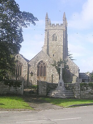
Stithians, also known as St Stythians, is a village and civil parish in Cornwall, England, United Kingdom. It lies in the middle of the triangle bounded by Redruth, Helston and Falmouth. Its population (2001) is 2,004, increasing to 2,101 at the 2011 census An electoral ward in the same name also exists but stretches north to St Day. The population here also at the 2011 census was 5,023.

St Day is a civil parish and village in Cornwall, England, United Kingdom. It is positioned between the village of Chacewater and the town of Redruth. The electoral ward St Day and Lanner had a population of 4,473 according to the 2011 census.

St Levan is a civil parish in Cornwall, England, United Kingdom. The parish is rural with a number of hamlets of varying size with Porthcurno probably being the best known. Hewn out of the cliff at Minack Point and overlooking the sea to the Logan Rock is the open-air Minack Theatre, the inspiration of Rowena Cade in the early 1930s.

Perranarworthal is a civil parish and village in Cornwall, England, United Kingdom. The village is about four miles (6.5 km) northwest of Falmouth and five miles (8 km) southwest of Truro. The parish population at the 2011 census was 1,496.

Gwennap is a village and civil parish in Cornwall, England, United Kingdom. It is about five miles (8 km) southeast of Redruth. Hamlets of Burncoose, Comford, Coombe, Crofthandy, Cusgarne, Fernsplatt, Frogpool, Hick's Mill, Tresamble and United Downs lie in the parish, as does Little Beside country house.

Kea is a civil parish and village in Cornwall, England, United Kingdom. It is a "large straggling parish" in a former mining area south of Truro.

Mawgan-in-Meneage is a civil parish in Cornwall, England, United Kingdom. It is situated in the Meneage district of The Lizard peninsula south of Helston in the former administrative district of Kerrier. The parish population at the 2011 census was 1437.

The hundred of Kerrier was the name of one of ten ancient administrative shires of Cornwall, in the United Kingdom. Kerrier is thought by Charles Thomas to be derived from an obsolete name of Castle Pencaire on Tregonning Hill, Breage. It is likely that an even earlier name for the district was Predannack which has been displaced by the Lizard Peninsula as a geographical name.

The Cornwall and West Devon Mining Landscape is a World Heritage Site which includes select mining landscapes in Cornwall and West Devon in the south west of England. The site was added to the World Heritage List during the 30th Session of the UNESCO World Heritage Committee in Vilnius, July 2006. Following plans in 2011 to restart mining at South Crofty, and to build a supermarket at Hayle Harbour, the World Heritage Committee drafted a decision in 2014 to put the site on the List of World Heritage in Danger, but this was rejected at the 38th Committee Session at Doha, Qatar, in favour of a follow-up Reactive Monitoring Mission.

Gwennap Head is a headland on the south coast of the Penwith peninsula, Cornwall, United Kingdom. It is within the parish of St Levan and approximately 4 miles (6.4 km) south of Land's End, and less than 1 mile (1.6 km) north-west of Porthgwarra, the nearest village. The area of Gwennap Head is designated as part of the Penwith Heritage Coast and also designated as part of the Cornwall Area of Outstanding Natural Beauty. The South West Coast Path closely follows the coastline around the headland.

Tregarden is a Grade II* listed large house built by the Barrett family in the late 16th century in the parish of St Mabyn, Cornwall, England.

The Williams family of Caerhays, Burncoose and Scorrier were owners of mines and smelting works for several generations during the Cornish Industrial Revolution. A branch of the family settled in Port Hope, Ontario.

Scorrier is a village in Cornwall, England, United Kingdom. It is in the civil parish of St Day, about 2 miles (3 km) northeast of the centre of Redruth and 3 miles (5 km) southeast of the coast at Porthtowan, on the A30 road at the junction of the A3047 road that leads west to Camborne and the B3298 road south to Carharrack. The Plymouth to Penzance railway line passes through the village and between 1852 and 1964 it had its own station. A. E. Rodda & Son, the principal maker of clotted cream is based here.
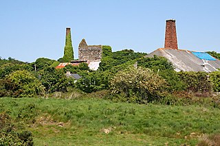
Wheal Busy, sometimes called Great Wheal Busy and in its early years known as Chacewater Mine, was a metalliferous mine halfway between Redruth and Truro in the Gwennap mining area of Cornwall, England. During the 18th century the mine produced enormous amounts of copper ore and was very wealthy, but from the later 19th century onwards was not profitable. Today the site of the mine is part of the Cornwall and West Devon Mining Landscape, a UNESCO World Heritage Site.

The Carnon viaduct carries a railway line from Truro to Falmouth – now branded the Maritime Line – over the valley of the Carnon River in west Cornwall, United Kingdom. The viaduct is situated half-a-mile northeast of Perranwell station which is five miles (8 km) from the line's terminus at Falmouth and three miles (5 km) from its junction with the Cornish main line at Truro.

Hicks Mill is a rural hamlet in Cornwall, England. it is situated around the what3words address: ///jeep.removals.nimbly and is about 7 km (4.3 mi) WSW from the cathedral city of Truro.

Merthen Manor is a 16th-century manor house in west Cornwall, England, UK. For most of its history it has been in the ownership of the prominent Cornish family, the Vyvyan family. The house is set in over 100 acres (40 ha) of woodland which, along with the shoreline of the Helford River, is designated as Merthen Woods Site of Special Scientific Interest (SSSI).

Carharrack, Gwennap and St Day was an electoral division of Cornwall in the United Kingdom which returned one member to sit on Cornwall Council between 2013 and 2021. It was abolished at the 2021 local elections, being succeeded by Redruth Central, Carharrack and St Day and Lanner, Stithians and Gwennap.