Related Research Articles

Dewey County is a county in the U.S. state of South Dakota. As of the 2020 census, the population was 5,239. Its county seat is Timber Lake. The county was created in 1883 and organized in 1910. It was named for William P. Dewey, Territorial surveyor-general from 1873 to 1877.

Cheyenne County is a county located in the U.S. state of Colorado. The county population was 1,748 at 2020 census. The county seat is Cheyenne Wells.

The Cheyenne River, also written Chyone, referring to the Cheyenne people who once lived there, is a tributary of the Missouri River in the U.S. states of Wyoming and South Dakota. It is approximately 295 miles (475 km) long and drains an area of 24,240 square miles (62,800 km2). About 60% of the drainage basin is in South Dakota and almost all of the remainder is in Wyoming.
Cherry Creek is a tributary of the Cheyenne River, approximately 50 mi (80 km), in central South Dakota in the United States.
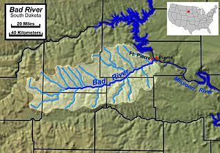
The Bad River is a tributary of the Missouri River, approximately 161 miles (259 km) long, in central South Dakota in the United States. The river is formed at Philip, South Dakota, by the confluence of its North and South forks. The North Fork Bad River rises in eastern Pennington County and flows 51 miles (82 km) east-southeast to Philip, while the South Fork Bad River rises at the confluence of Whitewater Creek and Big Buffalo Creek in Jackson County, within the Buffalo Gap National Grassland, and flows 36 miles (58 km) northeast to Philip. The main stem of the Bad River flows east-northeast from Philip, passing Midland and Capa. It joins the Missouri at Fort Pierre. The Bad drainage basin is about 3,000 square miles (7,800 km2) and is located south of the Cheyenne River in the Pierre Hills and Southern Plateaus.

The Battle of the Rosebud took place on June 17, 1876, in the Montana Territory between the United States Army and its Crow and Shoshoni allies against a force consisting mostly of Lakota Sioux and Northern Cheyenne Indians during the Great Sioux War of 1876. The Cheyenne called it the Battle Where the Girl Saved Her Brother because of an incident during the fight involving Buffalo Calf Road Woman. General George Crook's offensive was stymied by the Indians, led by Crazy Horse, and he awaited reinforcements before resuming the campaign in August.
French Creek is an intermittent stream located in the Black Hills region of western South Dakota, United States. It is a tributary of the Cheyenne River. French Creek flows year-round, but in drier periods it flows into an underground drainage near the eastern boundary of Custer State Park and never reaches the Cheyenne.

The Northern Cheyenne Tribe of the Northern Cheyenne Indian Reservation is the federally recognized Northern Cheyenne tribe. Located in southeastern Montana, the reservation is approximately 690 square miles (1,800 km2) in size and home to approximately 6,000 Cheyenne people. The tribal and government headquarters are located in Lame Deer, also the home of the annual Northern Cheyenne pow wow.

Boxelder Creek is a stream in Pennington, Meade and Lawrence counties, South Dakota, in the United States. It is a tributary of the Cheyenne River.
Elm Creek is a stream in Fall River and Custer counties, South Dakota, in the United States. It is a tributary of the Cheyenne River.
Chance is an unincorporated community in Perkins County, in the U.S. state of South Dakota. The community is just northeast of the confluence of Hart Creek and Thunder Butte Creek.
Battle Creek is a stream in the U.S. state of South Dakota. It is a tributary of the Cheyenne River, traversing Oglala Lakota and Pennington counties and the town of Keystone.
Bittersweet Creek is a stream in the U.S. state of South Dakota.
Blackfoot Creek is a stream in the U.S. state of South Dakota.
Buffalo Creek is a stream in the U.S. state of South Dakota.
Cheyenne Creek is a stream in the U.S. state of South Dakota.
Claymore Creek is a stream in the U.S. state of South Dakota.
Line Creek is a stream in the U.S. state of South Dakota.
Snake Creek is a stream in the U.S. state of South Dakota. It is a tributary of Grand River.
Tall Prairie Chicken Creek is a tributary of the Missouri River, located in Dewey County, South Dakota, United States, in the Cheyenne River Indian Reservation.
References
- ↑ U.S. Geological Survey Geographic Names Information System: Little Cheyenne Creek
- ↑ Federal Writers' Project (1940). South Dakota place-names, v.3. University of South Dakota. p. 4. Archived from the original on July 20, 2020.
45°03′46″N100°13′43″W / 45.06278°N 100.22861°W
| | This article related to a river in South Dakota is a stub. You can help Wikipedia by expanding it. |