Little Falling River

Last updated
Little Falling River
Country United States
Physical characteristics
Main source Virginia

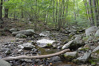
The Little Falling River is a river in the United States state of Virginia.

United States Federal republic in North America

The United States of America (USA), commonly known as the United States or America, is a country comprising 50 states, a federal district, five major self-governing territories, and various possessions. At 3.8 million square miles, the United States is the world's third or fourth largest country by total area and is slightly smaller than the entire continent of Europe's 3.9 million square miles. With a population of over 327 million people, the U.S. is the third most populous country. The capital is Washington, D.C., and the largest city by population is New York City. Forty-eight states and the capital's federal district are contiguous in North America between Canada and Mexico. The State of Alaska is in the northwest corner of North America, bordered by Canada to the east and across the Bering Strait from Russia to the west. The State of Hawaii is an archipelago in the mid-Pacific Ocean. The U.S. territories are scattered about the Pacific Ocean and the Caribbean Sea, stretching across nine official time zones. The extremely diverse geography, climate, and wildlife of the United States make it one of the world's 17 megadiverse countries.

U.S. state constituent political entity of the United States

In the United States, a state is a constituent political entity, of which there are currently 50. Bound together in a political union, each state holds governmental jurisdiction over a separate and defined geographic territory and shares its sovereignty with the federal government. Due to this shared sovereignty, Americans are citizens both of the federal republic and of the state in which they reside. State citizenship and residency are flexible, and no government approval is required to move between states, except for persons restricted by certain types of court orders. Four states use the term commonwealth rather than state in their full official names.

Virginia State of the United States of America

Virginia, officially the Commonwealth of Virginia, is a state in the Southeastern and Mid-Atlantic regions of the United States located between the Atlantic Coast and the Appalachian Mountains. Virginia is nicknamed the "Old Dominion" due to its status as the first English colonial possession established in mainland North America and "Mother of Presidents" because eight U.S. presidents were born there, more than any other state. The geography and climate of the Commonwealth are shaped by the Blue Ridge Mountains and the Chesapeake Bay, which provide habitat for much of its flora and fauna. The capital of the Commonwealth is Richmond; Virginia Beach is the most populous city, and Fairfax County is the most populous political subdivision. The Commonwealth's estimated population as of 2018 is over 8.5 million.

See also

Related Research Articles

The Virginia Seismic Zone in the U.S. state of Virginia covers about 8,000 square kilometres (3,100 sq mi) in the Piedmont province. Earthquakes in the state are irregular and rarely reach over 4.5 in magnitude.

Wintergreen, Virginia human settlement in Virginia, United States of America

Wintergreen is a census-designated place (CDP) in Augusta and Nelson counties, Virginia, United States, located near Wintergreen Resort. The population as of the 2010 Census was 165.

The Big Otter River is a river in the United States state of Virginia.

Buffalo Creek is a 21.1-mile-long (34.0 km) tributary of the Appomattox River in the U.S. state of Virginia. Flowing entirely through Prince Edward County, it joins the Appomattox River at Farmville.

The Bush River is a 22.6-mile-long (36.4 km) tributary of the Appomattox River in the U.S. state of Virginia. It rises northeast of Keysville near the junction of the boundaries between Charlotte, Prince Edward, and Lunenburg counties. It flows northeast through Prince Edward County and joins the Appomattox River 3 miles (5 km) east of Farmville.

The Conway River is a 14.4-mile-long (23.2 km) river in the U.S. state of Virginia. Rising near the triple junction of Madison, Greene and Page counties at the crest of Shenandoah National Park, the river flows south, then southeast to the Rapidan River northwest of Burtonville. The river is part of the Rappahannock River watershed.

Hughes River (Virginia) river in the United States of America

The Hughes River is a 14.0-mile-long (22.5 km) river in Madison, Rappahannock, and Culpeper counties in the U.S. state of Virginia. The river rises on the east slope of Stony Man mountain in Shenandoah National Park and flows southeast past the village of Nethers to join the Hazel River west of Boston, Virginia. Via the Hazel River and the Rappahannock River, the Hughes River is part of the Chesapeake Bay watershed.

The Little Otter River is a river in Bedford County in the U.S. state of Virginia.

The Little River is a river in the U.S. state of Virginia. It rises near Maiden Spring in Tazewell County, Virginia, and empties into the Clinch River in Russell County.

The Little Willis River is a 15.5-mile-long (24.9 km) tributary of the Willis River in the U.S. state of Virginia. It is part of the James River watershed. It rises in Buckingham County and flows east into Cumberland County, joining the Willis River 9 miles (14 km) north of Farmville.

The Middle River is a 70.6-mile-long (113.6 km) river in the U.S. state of Virginia. Flowing entirely within Augusta County, the Middle River joins the North River, which in turn meets the South River at Port Republic to form the South Fork Shenandoah River.

The North Meherrin River is a river in the United States state of Virginia.

The North River is a 9.3-mile-long (15.0 km) tributary of the Slate River in Buckingham County in the U.S. state of Virginia. It is part of the James River watershed.

The Piney River is a 16.5-mile-long (26.6 km) tributary of the Tye River in the U.S. state of Virginia. It is part of the James River watershed.

Pound River river in the United States of America

Running through Part of Wise County Virginia, and through Dickenson County Virginia, The Pound River is a river in the U.S. state of Virginia. It runs from the North Fork Pound Reservoir to the John W. Flannagan Dam. Via the Russell Fork, the Levisa Fork, the Big Sandy River, and the Ohio River, it is part of the Mississippi River watershed.

Sandy River is a 12.9-mile-long (20.8 km) tributary of the Bush River in the U.S. state of Virginia. Via the Bush River and the Appomattox River, it is part of the James River watershed. It rises in Prince Edward County northeast of the village of Green Bay and flow north through Prince Edward State Forest and farmland, joining the Bush River less than one mile south of that river's confluence with the Appomattox near the town of Farmville.

The Slate River is a 48.8-mile-long (78.5 km) tributary of the James River in the U.S. state of Virginia. It rises about 10 miles (16 km) northeast of Appomattox and flows northeast past Buckingham, eventually reaching the James River near Bremo Bluff. The river's course is entirely within Buckingham County.

The South Meherrin River is a river in the United States state of Virginia.

The Staunton River is a 4.1-mile-long (6.6 km) stream in the U.S. state of Virginia. Flowing entirely within Shenandoah National Park, it is a tributary of the Rapidan River and part of the Rappahannock River watershed.

Curdsville is an unincorporated community in Buckingham County, in the U.S. state of Virginia.

References

    International Standard Book Number Unique numeric book identifier

    The International Standard Book Number (ISBN) is a numeric commercial book identifier which is intended to be unique. Publishers purchase ISBNs from an affiliate of the International ISBN Agency.

    Coordinates: 37°13′06″N78°49′59″W / 37.2182016°N 78.8330668°W / 37.2182016; -78.8330668

    Geographic coordinate system Coordinate system

    A geographic coordinate system is a coordinate system that enables every location on Earth to be specified by a set of numbers, letters or symbols. The coordinates are often chosen such that one of the numbers represents a vertical position and two or three of the numbers represent a horizontal position; alternatively, a geographic position may be expressed in a combined three-dimensional Cartesian vector. A common choice of coordinates is latitude, longitude and elevation. To specify a location on a plane requires a map projection.