
Raes Junction is a small settlement in New Zealand, located at the intersection of State Highways 8 and 90, in the lower South Island. The highways which meet at the junction are the main routes to the Clutha valley for travellers from Dunedin and Invercargill respectively.

The Clutha River / Mata-Au is the second longest river in New Zealand and the longest in the South Island. It flows south-southeast 338 kilometres (210 mi) through Central and South Otago from Lake Wanaka in the Southern Alps to the Pacific Ocean, 75 kilometres (47 mi) south west of Dunedin. It is the highest volume river in New Zealand, and the swiftest, with a catchment of 21,960 square kilometres (8,480 sq mi), discharging a mean flow of 614 cubic metres per second (21,700 cu ft/s). The Clutha River is known for its scenery, gold-rush history, and swift turquoise waters. A river conservation group, the Clutha Mata-Au River Parkway Group, is working to establish a regional river parkway, with a trail, along the entire river corridor. The name of the river was changed to a dual name by the Ngai Tahu Claims Settlement Act 1998.

Cromwell is a town in Central Otago in the Otago region of New Zealand.
West Otago is the local name given to part of the region of Otago, New Zealand, lying close to the border with Southland. It is administratively connected to South Otago, but is geographically separated from it by a range of hills known as the Blue Mountains. The largest settlements in West Otago are Tapanui and Heriot, and other localities within the area include Moa Flat, Edievale, Merino Downs, and Waikoikoi. The area described as West Otago is sometimes extended to include Lawrence and Beaumont. The ghost town of Kelso also lies within West Otago. Other notable features of the area include Conical Hill and Landslip Hill, the latter being a major fossil-bearing formation.

The Manuherikia River is located in Otago in the South Island of New Zealand. It rises in the far north of the Maniototo, with the West Branch draining the eastern side of the St Bathans Range, and the East Branch draining the western flanks of the Hawkdun Range. The river continues southwest through the wide Manuherikia Valley to its confluence with the Clutha River at Alexandra. During the 1860s the Manuherikia was one of the centres of the Central Otago Gold Rush.

Gabriel's Gully is a locality in Otago, New Zealand, three kilometres from Lawrence township and close to the Tuapeka River.

Clutha District is a local government district of southern New Zealand, with its headquarters in the Otago town of Balclutha. The Clutha District has a land area of 6,362.86 km² and a 2006 census population of 16,839 usual residents. Clutha District occupies the majority of the geographical area known as South Otago.
The Tapanui Branch was a railway line located near the border of the regions of Southland and Otago, New Zealand. Although the name suggests that it terminated in Tapanui, its furthest terminus was actually in Edievale. Construction of the line began in 1878 with the first section opened in 1880, and it operated until 1978, when it was destroyed by flooding from the Pomahaka River.
Beaumont is a small town in inland Otago, in the South Island of New Zealand. It is located on the Clutha River six kilometres southeast of Raes Junction, between Roxburgh and Balclutha. Beaumont is connected to Milton and Roxburgh by State Highway 8.
Blue Mountains are a range of rugged hills in West Otago, in southern New Zealand. They form a barrier between the valleys of the Clutha and Pomahaka Rivers. They lie between the towns of Tapanui and Lawrence and rise to 1019 metres (3280 ft).

Kelso is an abandoned small settlement in Otago, New Zealand, located ten kilometres north of Tapanui on the Crookston Burn, close to its junction with the larger Pomahaka River. Its population during the 1960s and 1970s was close to 300, with most of its economy based on sheep farming. A small dairy factory was a focal point in the village's early years.
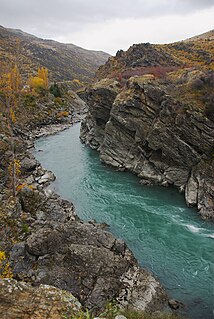
The Kawarau Gorge is a major river gorge, located in Central Otago, in the South Island of New Zealand. The Kawarau River flows through the gorge, which is located between the towns of Queenstown and Cromwell, and part of the route of State Highway 6 also follows the gorge.
The Teviot River is a river in New Zealand, a tributary of the Clutha River.
The Waikaia River is a river in New Zealand, a tributary of the Mataura River.
The Waipahi River is a river in New Zealand, a tributary of the Pomahaka River.
Francis Wallace Mackenzie was a 19th-century Member of Parliament from Otago, New Zealand.
State Highway 90 is a New Zealand State Highway connecting the town of Gore on State Highway 1 to the locality of Raes Junction on State Highway 8 via Tapanui, servicing the agricultural areas of eastern Southland and West Otago. It is mostly hilly and is just under 60 kilometres long.
Becks is a small settlement in the Otago Region of the South Island of New Zealand. It is located on State Highway 85, some 16 kilometres (9.9 mi) north-east of Omakau, and just west of where the State Highway crosses the Manuherikia River. It lies on the 45th parallel south.

