
The Arctic Archipelago, also known as the Canadian Arctic Archipelago, is an archipelago lying to the north of the Canadian continental mainland, excluding Greenland and Iceland.

Northern Manitoba is a geographic and cultural region of the Canadian province of Manitoba. Originally encompassing a small square around the Red River Colony, the province was extended north to the 60th parallel in 1912. The region's specific boundaries vary, as "northern" communities are considered to share certain social and geographic characteristics, regardless of latitude.

The Little Roussel, also known as the Petit Ruau or Little Russel, is a channel running between the isle of Herm and Guernsey in the Channel Islands.
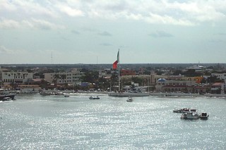
San Miguel de Cozumel is the largest city in Cozumel Municipality in the Mexican state of Quintana Roo. With a 2010 census population of 77,236, it is also Quintana Roo's fourth-largest community, after Cancún, Chetumal, and Playa del Carmen. It is a hub for tourism on the Riviera Maya, providing the sole ferries between the Mexican mainland and the island. In addition to the ferry service to Playa del Carmen, the first international cruise terminal in Quintana Roo is located in the city.
Bonfire Shelter is an archaeological site located in a southwest Texas rock shelter, near Langtry, Texas. This archaeological site contains evidence of mass American buffalo hunts, a phenomenon that is usually associated with the Great Plains hundreds of miles to the north. This site is the southernmost site that has been located in North America where mass bison hunts have taken place, and also the earliest known.

Little Qualicum Falls Provincial Park is a provincial park in British Columbia, Canada, on central Vancouver Island, that encompasses the entire southern shore of Cameron Lake. The Island Rail Corridor line to Port Alberni passes through the park.

Mount Elphinstone Provincial Park is a provincial park located near BC Highway 101, in British Columbia, Canada. Located near Mount Elphinstone, the park is on the west side of Howe Sound and north of the town of Gibsons and near the community of Roberts Creek. Created in 2000, the park is approximately 141 hectares in size.
Sproat Lake Provincial Park is a provincial park near Port Alberni in British Columbia, Canada's Vancouver Island. Its name derives from a lake named after 19th century entrepreneur and colonial official Gilbert Malcolm Sproat.
Gillams is a town located north west of the city of Corner Brook in the Canadian province of Newfoundland and Labrador.

Grand Detour Township is located in Ogle County, Illinois. As of the 2010 census, its population was 698 and it contained 385 housing units.

Lark Harbour is small fishing community on the western coast of Newfoundland, on the south side of the Bay of Islands, and west of the City of Corner Brook.

The municipality of Trabazos is located in the west of the Zamora Province, on the border with Portugal, 75 km from the provincial capital. The municipality is made of the five villages of Latedo, Nuez de Aliste, San Martín del Pedroso, Trabazos and Villarino Tras la Sierra.

Carievale is a village in the Canadian province of Saskatchewan within the Rural Municipality of Argyle No. 1 and Census Division No. 1. The village lies at the intersection of Highway 8 and Highway 18.
Port au Port East is a town in the Canadian province of Newfoundland and Labrador, situated on the shore of Isthmus Bay. The town had a population of 413 in the Canada 2021 Census. The town consists of the unincorporated communities of Port au Port and Romaines.
The Headland of Cape St. Gregory is north of the abandoned community of Chimney Cove of the west coast of the island of Newfoundland in the Canadian province of Newfoundland and Labrador.
The Rural Municipality of Wallace is a former rural municipality (RM) in the Canadian province of Manitoba. It was originally incorporated as a rural municipality on December 22, 1883. It ceased on January 1, 2015 as a result of its provincially mandated amalgamation with the RM of Woodworth and the Village of Elkhorn to form the Rural Municipality of Wallace – Woodworth.
Crystal Hill is a hamlet in Terrell Rural Municipality No. 101 in the province of Saskatchewan, Canada. The hamlet is located 21 km east of Highway 36 on Highway 713. Very little remains of Crystal Hill.
Woody Bay is a natural bay on the island of Newfoundland in the province of Newfoundland and Labrador, Canada. Located 0.5 miles (0.80 km) from Little Port, Woody Bay is about two cables in diameter, and fit for boats only, that have considerable difficulty in entering with westerly winds.
Fry's, more commonly known as Frys, is a former locality in Antler Rural Municipality No. 61, Saskatchewan, Canada. The hamlet is approximately 10 km east of the town of Redvers along Highway 13 and the Canadian Pacific Railway line. Very little remains of the community of Fry's.
Galilee is an unincorporated community in Terrell Rural Municipality No. 101, Saskatchewan, Canada. The community is located on Highway 36 about 50 km south of the city of Moose Jaw. Very little remains of the community other than an old general store and a private residence. It is thus regularly described as a ghost town by travellers.

