
Louisa is a town in Louisa County, Virginia, United States. The population was 1,555 at the 2010 census. It is the county seat of Louisa County.

The York River is a navigable estuary, approximately 34 miles (55 km) long, in eastern Virginia in the United States. It ranges in width from 1 mile (1.6 km) at its head to 2.5 miles (4.0 km) near its mouth on the west side of Chesapeake Bay. Its watershed drains an area of the coastal plain of Virginia north and east of Richmond.

Southern West Virginia is a culturally and geographically distinct region in the U.S. state of West Virginia. Southern West Virginia has coal mining heritage and Southern affinity, including being part of the Bible Belt. The region is also closely identified with Southwestern Virginia and Eastern Kentucky, with close proximity to Western North Carolina and East Tennessee, which are all part of Appalachia and the Upland South.
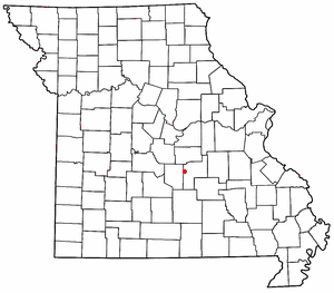
Jerome is an unincorporated community in western Phelps County, Missouri, United States. It is located on the Gasconade River near Interstate 44, and is approximately ten miles west of Rolla, near the edge of the Mark Twain National Forest.
Grotons is an unincorporated community in Accomack County, Virginia.
Johnson Cove is an unincorporated community in Northampton County, Virginia, United States.
The Cranes Nest River is a 25.0-mile-long (40.2 km) river in the U.S. state of Virginia. It is located in Dickenson County in the southwestern part of the state. It is part of the Mississippi River watershed.
The Little Otter River is a river in Bedford County in the U.S. state of Virginia.
The McClure River is a 17.9-mile-long (28.8 km) tributary of the Russell Fork in the U.S. state of Virginia. It is located in Dickenson County in the southwestern part of the state. Via the Russell Fork, the Levisa Fork, the Big Sandy River, and the Ohio River, it is part of the Mississippi River watershed.

The Pound River is a river in the U.S. state of Virginia, running through part of Wise County and through Dickenson County. Its North and South forks join in the town of Pound and flow northeast into the reservoir impounded by the John W. Flannagan Dam, where it is joined by the waters of the Cranes Nest River. About a mile and a half downstream from the dam the Pound flows into the Russell Fork of the Big Sandy River, which flows into the Ohio River.
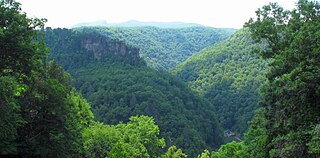
The Russell Fork is a 51.9-mile-long (83.5 km) tributary of the Levisa Fork in southwestern Virginia and southeastern Kentucky in the United States. Known for its whitewater, it rises in the Appalachian Mountains of southwest Virginia, in southern Buchanan County at the base of Big A Mountain, and flows northwest into Dickenson County. The Russell Fork continues to flow through the town of Haysi, Virginia, the Breaks Interstate Park, and the town of Elkhorn City, Kentucky, in Pike County, to the community of Millard, Kentucky where it flows into the Levisa Fork which, together with the Tug Fork, form the Big Sandy River.
The South River is a 20.3-mile-long (32.7 km) tributary of the Maury River in the U.S. state of Virginia. It is part of the James River watershed.

Swift Creek is a 44.9-mile-long (72.3 km) river in the U.S. state of Virginia. It rises west of Richmond in Powhatan County near U.S. Route 60 and travels southeast through Powhatan County and into Chesterfield County southwest of Hallsboro. Swift Creek flows to the north side of the Swift Creek Reservoir. After a series of twists and turns it courses into Pocahontas State Park, where it then forms Swift Creek Lake. After flowing out of Pocahontas State Park and into southeastern Chesterfield County, it eventually forms the northern boundary of Colonial Heights, where it joins the Appomattox River.

Kilgore is an unincorporated community in Loudon Township, Carroll County, Ohio, United States. The community is part of the Canton–Massillon Metropolitan Statistical Area. The community is served by the Carrollton post office, ZIP code 44615. It lies at the intersection of State routes 9 and 164.
Sheep Creek is a geographical place name. With variations, the name is given to hundreds of bodies of water, roads, canals, reservoirs and populated areas in the United States and other countries. It is the name of a tributary to Lockyear Creek in Queensland, Australia, and the name of at least three bodies of water in Canada. The U.S. state of Montana has 85 different locales that bear that name or a derivation. The U.S. state of Idaho has 92 natural and man-made areas that incorporate Sheep Creek into their names. Nature areas that include trails named Sheep Creek can be found in Canada's Yukon Territory, Colorado's Larimer County and in Utah's Bryce Canyon National Park.
Cavenders Creek is a stream in Georgia, and is a tributary of the Chestatee River. The creek is approximately 3.43 miles (5.52 km) long.
Whitestick Creek is a stream in the U.S. state of West Virginia. The stream is a tributary of Piney Creek which it joins just south of the city of Beckley.
Pike Creek is a stream in Carter and Shannon counties in the Ozarks of southern Missouri. It is a tributary of the Current River.
Kaintuck Hollow is a valley in western Phelps County in the Ozarks of Missouri.
Maggodee Creek is a creek in Franklin County in the United States state of Virginia. The creek is a southeast-flowing tributary of the Blackwater River, part of the Roanoke River watershed.
