
Polk County is a county located in the U.S. state of North Carolina. As of the 2010 census, the population was 20,510. Its county seat is Columbus. The county was formed in 1855 from parts of Henderson County and Rutherford County. It was named for William Polk, a colonel in the American Revolutionary War. The Tryon International Equestrian Center, close to the community of Mill Spring was the location of the 2018 FEI World Equestrian Games.
Saluda is a town in Saluda County, South Carolina, United States, along the Little Saluda River. The population was 3,565 at the 2010 census. It is the county seat of Saluda County.

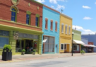
Saluda is a city in Polk and Henderson counties in the U.S. state of North Carolina. The population was 713 at the 2010 census. Saluda is famous for sitting at the top of the Norfolk Southern Railway's Saluda Grade, which was the steepest main line standard-gauge railway line in the United States until Norfolk Southern ceased operations on the line in 2001. Saluda is close to the South Carolina state line, between Asheville, North Carolina, and Spartanburg, South Carolina.

U.S. Route 378 is a spur of US 78 in the U.S. states of Georgia and South Carolina. The U.S. Highway runs 234.30 miles (377.07 km) from US 78, Georgia State Route 10, SR 17, and SR 47 in Washington, Georgia, east to US 501 Business in Conway, South Carolina. US 378 connects the Central Savannah River Area in both states with the Midlands and Pee Dee regions of South Carolina. The U.S. Highway's western portion, which connects Washington and Lincolnton in Georgia and McCormick, Saluda, and Lexington in South Carolina, is mainly a rural highway. US 378 is a major suburban and urban highway through Lexington and the South Carolina state capital, Columbia. The highway has a lengthy concurrency with US 76 between Columbia and Sumter and serves as a major route between the Midlands and the Myrtle Beach area, between which the highway has a business route through Lake City.
The Oolenoy River is a minor tributary of the Saluda River sourced near Sassafras Mountain in northern Pickens County, South Carolina. Approximately 37 miles in length, it empties into the South Fork Saluda River near the Pumpkintown Community. It is part of the Santee River System.

The Congaree River is a short but wide river in South Carolina in the United States; It flows for approximately 53 miles (85 km). The river serves an important role as the final outlet channel for the entire Lower Saluda and Lower Broad watersheds, before merging with the Wateree River just north of Lake Marion to form the Santee River.
Saluda may refer to any of the following in the United States:

The Broad River is a principal tributary of the Congaree River, about 150 miles (240 km) long, in western North Carolina and northern South Carolina in the United States. Via the Congaree, it is part of the watershed of the Santee River, which flows to the Atlantic Ocean.

Lake Murray is a reservoir in the U.S. state of South Carolina. It is approximately 50,000 acres in size, and has roughly 650 mi of shoreline. It was impounded in the late 1920s to provide hydroelectric power to the state of South Carolina. Lake Murray is fed by the Saluda River, which flows from upstate South Carolina near the North Carolina state line. The Saluda Dam was an engineering feat at the time of its construction. The dam, using the native red clay soil and bedrock, was the largest earthen dam in the world when it was completed in 1930. Lake Murray itself is named after the project's chief engineer, William S. Murray. The Saluda Dam is approximately 1.5 miles (2.4 km) long and 220 feet (67 m) high. Lake Murray is 41 miles (66 km) long, and 14 miles (23 km) wide at its widest point. At the time when the lake was finished, it was the world's largest man-made reservoir.

The Saluda River is a principal tributary of the Congaree River, about 200 mi (320 km) long, in northern and western South Carolina in the United States. Via the Congaree River, it is part of the watershed of the Santee River, which flows to the Atlantic Ocean.

The Reedy River is a tributary of the Saluda River, about 65 miles (105 km) long, in northwestern South Carolina in the United States. Via the Saluda and Congaree Rivers, it is part of the watershed of the Santee River, which flows to the Atlantic Ocean.
The Bush River is a tributary of the Saluda River, 30 mi (48 km) long, in the Piedmont region of western South Carolina in the United States. Via the Saluda and Congaree Rivers, it is part of the watershed of the Santee River, which flows to the Atlantic Ocean.
Little River may refer to ten streams by that name in the U.S. state of North Carolina:

Interstate 26 (I-26) is a South Carolina Interstate highway running generally east–west from near Landrum, in Spartanburg County, to U.S. Route 17, in Charleston, South Carolina. It is also the longest interstate highway in South Carolina.

South Carolina Highway 121 (SC 121) is a major state highway that runs north and south in the western part of the U.S. state of South Carolina. The road is actually part of a long multi-state route that also goes through Florida and Georgia. Some see it as a de facto auxiliary route from U.S. Route 21 (US 21) in Rock Hill. Efforts to have the road upgraded to such status have failed however.
South Carolina Highway 391 (SC 391) is a 34.8-mile-long (56.0 km) state highway in the U.S. state of South Carolina. The highway connects rural areas of Aiken County with Prosperity, via Batesburg-Leesville.