Little Creek is a town in Kent County, Delaware, United States. It is part of the Dover, Delaware Metropolitan Statistical Area. The population was 224 at the 2010 census.

Pike Creek is a census-designated place (CDP) in New Castle County, Delaware and is part of the Philadelphia-Camden-Wilmington, PA-NJ-DE-MD Metropolitan statistical area. In 2017, CNN's Money Magazine ranked Pike Creek number 2 on its list of the 10 Best Places to Live in the United States. Pike Creek was the only community in Delaware to appear on the list. The population was 7,898 at the 2010 census. Local attractions include Middle Run Natural Area, White Clay Creek State Park, Carousel Farm Park & Equestrian Center, Golf and Restaurants. Pike Creek is approximately 5 miles from downtown Newark, Delaware which contains the University of Delaware. Pike Creek is connected to the University of Delaware campus and the Newark, Delaware downtown area by several bike trails. Pike Creek is approximately 10 miles west of the state's largest city, Wilmington, Delaware which is a national financial center. Chester County, Pennsylvania is located approximately 2 miles west of Pike Creek.

Seneca Creek is a 5.8-mile-long (9.3 km) stream in Montgomery County, Maryland, USA, roughly 16 miles (26 km) northwest of Washington, D.C. It drains into the Potomac River.

The Bohemia River is a 4.7-mile-long (7.6 km) tributary of the Elk River on the Delmarva Peninsula. It is located in Cecil County, Maryland, with its headwaters extending into New Castle County, Delaware.
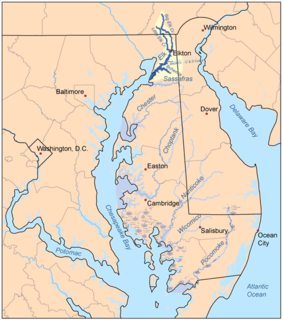
The Elk River is a tidal tributary of the Chesapeake Bay on the Eastern Shore of Maryland and on the northern edge of the Delmarva Peninsula. It is about 15 miles (24 km) long. As the most northeastern extension of the Chesapeake Bay estuary, it has served as one entrance to the Chesapeake & Delaware Canal since the 19th century. The canal and river now serve as one boundary of the Elk Neck Peninsula. The river flows through Cecil County, Maryland, with its watershed extending into New Castle County, Delaware and Chester County, Pennsylvania. Elkton, the county seat of Cecil County, is located at its head. Its total watershed area is 143 square miles (370 km2), with 21 square miles (54 km2) of open water, so its watershed is 15% open water. It is south and east of the North East River, and north of the Sassafras River.

Marshallton is an unincorporated community in Mill Creek Hundred, New Castle County, Delaware, United States. The community was founded in 1836 and is named for John Marshall, mill owner.
Little Wills Creek is a 16.3-mile-long (26.2 km) tributary of Wills Creek in Bedford County, Pennsylvania, in the United States.
Isaacs Creek is a 15.0-mile-long (24.1 km) tributary stream of Back Creek in Frederick County, Virginia. Isaacs Creek rises on Timber Ridge at the boundary line with Hampshire County, West Virginia, and flows into Back Creek at Grave Hill shortly before Back Creek's confluence with Hogue Creek. The stream is dammed to create Lake Holiday.
Little Tonoloway Creek is a 20.2-mile-long (32.5 km) tributary of Tonoloway Creek in Fulton County, Pennsylvania in the United States.
Centre Township was a township that existed in Camden County, New Jersey, United States, from 1855 through 1926.

Dalton Township is one of fifteen townships in Wayne County, Indiana, United States. As of the 2010 census, its population was 566 and it contained 239 housing units.
The A586 is a road in England, which runs from Garstang to Blackpool, in Lancashire.
Fort Nassau was a factorij in New Netherland between 1627–1651 located at the mouth of Big Timber Creek at its confluence with the Delaware River. It was the first known permanent European-built structure in what would become the state of New Jersey. The creek name is a derived from the Dutch language Timmer Kill as recorded by David Pietersen de Vries in his memoirs of his journey of 1630–1633. The Delaware Valley and its bay was called the "South River" ; the "North River" of the colony was the Hudson River. The factorij was established for the fur trade, mostly in beaver pelts, with the indigenous populations of Susquehannock, who spoke an Iroquoian language, and the Lenape, whose language was of the Algonquian family. They also wanted to retain a physical claim to the territory.
Fort Beversreede was a Dutch-built palisaded factorij located near the confluence of the Schuylkill River and the Delaware River. It was an outpost of the colony of New Netherland, which was centered on its capital, New Amsterdam (Manhattan), on the North River.
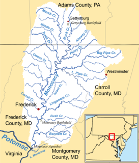
Double Pipe Creek, sometimes called Pipe Creek, is a major tributary of the Monocacy River in Carroll County and Frederick County in Maryland, located several miles north and west of Westminster. The creek is only 1.6 miles (2.6 km) long, but is formed by the confluence of two much longer streams, Big Pipe Creek and Little Pipe Creek.
Broad Creek Hundred is a hundred in Sussex County, Delaware, United States. Broad Creek Hundred was formed in 1775 from Somerset County, Maryland. Its primary community is Bethel.
Duck Creek Hundred is a hundred in Kent County, Delaware, United States. Duck Creek Hundred was formed in 1682 as one of the original Delaware Hundreds. Its primary community is Smyrna.
The Cope's Bridge is a stone arch bridge which carries Strasburg Road across the East Branch Brandywine Creek in East Bradford Township, Chester County, Pennsylvania. The bridge is listed on the National Register of Historic Places and is located at 39°57′31.9″N75°39′19.3″W. It is in the Taylor-Cope Historic District.
Burr Oak Creek is a stream in Jackson County in the U.S. state of Missouri. It is a tributary of Little Blue River.
Cottonwood Creek is a stream in Lafayette County in the U.S. state of Missouri. It is a tributary of Little Tabo Creek.