| Little Walla Walla River | |
|---|---|
 | |
| Location | |
| Country | United States |
| State | Oregon |
| County | Umatilla |
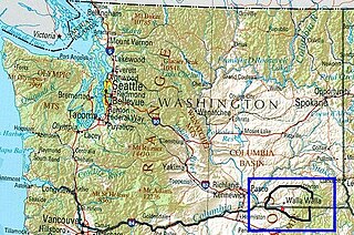
Little Walla Walla River is a stream in the U.S. state of Oregon. [1]
| Little Walla Walla River | |
|---|---|
| | |
| Location | |
| Country | United States |
| State | Oregon |
| County | Umatilla |
Little Walla Walla River is a stream in the U.S. state of Oregon. [1]
Walla Walla County is a county located in the southeast of the U.S. state of Washington. As of the 2020 census, its population was 62,584. The county seat and largest city is Walla Walla. The county was formed on April 25, 1854 and is named after the Walla Walla tribe of Native Americans.

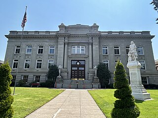
Umatilla County is one of the 36 counties in the U.S. state of Oregon. The population of 81,826 ranks it as the 14th largest in Oregon, and largest in Eastern Oregon. Hermiston is the largest city in Umatilla County, but Pendleton remains the county seat. Umatilla County is part of the Hermiston-Pendleton, OR Micropolitan Statistical Area, which has a combined population of 94,833. It is included in the eight-county definition of Eastern Oregon.
The Inland Northwest, historically and alternatively known as the Inland Empire, is a region of the American Northwest centered on the Greater Spokane, Washington Area, encompassing all of Eastern Washington and North Idaho. Under broader definitions, Northeastern Oregon and Western Montana may be included in the Inland Northwest. Alternatively, stricter definitions may exclude Central Washington and Idaho County, Idaho.

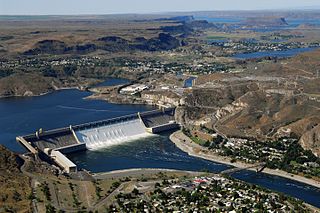
The Columbia Plateau is an important geologic and geographic region that lies across parts of the U.S. states of Washington, Oregon, and Idaho. It is a wide flood basalt plateau between the Cascade Range and the Rocky Mountains, cut through by the Columbia River.

The Umatilla Indian Reservation is an Indian reservation in the Pacific Northwest of the United States. It was created by The Treaty of 9 June 1855 between the United States and members of the Walla, Cayuse, and Umatilla tribes. It lies in northeastern Oregon, east of Pendleton. The reservation is mostly in Umatilla County, with a very small part extending south into Union County. It is managed by the three Confederated Tribes of the Umatilla Indian Reservation.

Fort Walla Walla is a United States Army fort located in Walla Walla, Washington. The first Fort Walla Walla was established July 1856, by Lieutenant Colonel Edward Steptoe, 9th Infantry Regiment. A second Fort Walla Walla was occupied September 23, 1856. The third and permanent military Fort Walla Walla was built in 1858 and adjoined Steptoeville, now Walla Walla, Washington, a community that had grown up around the second fort. An executive order on May 7, 1859 declared the fort a military reservation containing 640 acres devoted to military purposes and a further 640 acres each of hay and timber reserves. On September 28, 1910 soldiers from the 1st Cavalry lowered the flag closing the fort. In 1917, the fort briefly reopened to train men of the First Battalion Washington Field Artillery in support of action in World War I. In 1921, the fort and property were turned over to the Veterans Administration where 15 original buildings from the military era remain. Today, the complex contains a park, a museum, and the Jonathan M. Wainright Memorial VA Medical Center.
Mullan Road was the first wagon road to cross the Rocky Mountains to the Inland of the Pacific Northwest. It was built by U.S. Army troops under the command of Lt. John Mullan, between the spring of 1859 and summer 1860. It led from Fort Benton, which at the time was in the Dakota Territory, then Idaho Territory from July 1863, and into Montana Territory beginning in May 1864. The road eventually stretched all the way from Fort Walla Walla, Washington Territory, near the Columbia River to the navigational head of the Missouri River, which at the time was the farthest inland port in the world). The road previewed the route approximately followed by modern-day Interstate 15 and Interstate 90 through present-day Montana, Idaho, and Washington.
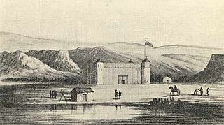
Fort Nez Percés, later known as (Old) Fort Walla Walla, was a fortified fur trading post on the Columbia River on the territory of modern-day Wallula, Washington. Despite being named after the Nez Perce people, the fort was in the traditional lands of the Walla Walla. Founded in 1818 by the North-West Company, after 1821 it was run by the Hudson's Bay Company until its closure in 1857.
The Vansycle I Wind Project is a wind farm in Umatilla County, Oregon. It consists of 38 Vestas 0.66 MW wind turbines at the upper end of Vansycle Canyon with a collective nameplate generating capacity of 25.08 MW. The project was the first commercial wind energy project constructed and operated in Oregon and began operation in December 1998.

Walla Walla Valley is an American Viticultural Area (AVA) located within Washington state and extending partly into the northeastern corner of Oregon. The wine region is entirely included within the larger Columbia Valley AVA. In addition to grapes, the area produces sweet onions, wheat and strawberries After the Yakima Valley AVA, the Walla Walla AVA has the second highest concentration of vineyards and wineries in Washington State. Walla Walla hosts about 140 wineries. The area was recognized on March 7, 1984 by the Bureau of Alcohol, Tobacco and Firearms (ATF), Treasury after reviewing the petition submitted by Mr. Richard L Small, President of the Walla Walla Valley Winegrowers Association, for the establishment of a viticultural area in southeast Washington and northeast Oregon, east of Lake Wallula, to be known as "Walls Walls Valley." At the time, Walla Walla Valley viticultural area was approximately 178,560 acres (279 sq mi) with two bonded wineries and about 60 acres (24 ha) from several vineyards.

Blue Mountain Community College is a public community college in Pendleton, Oregon, United States. It serves Umatilla and Morrow counties as well as most of Baker County. It was established in 1962 and offers Associate of Arts degrees, Associate of Science degrees, Associate of Applied Science degrees, certificates, and transfer degrees to four-year colleges.

The Oregon Railroad and Navigation Company (OR&N) was a rail and steamboat transport company that operated a rail network of 1,143 miles (1,839 km) running east from Portland, Oregon, United States, to northeastern Oregon, northeastern Washington, and northern Idaho. It operated from 1896 as a consolidation of several smaller railroads.

Wildhorse Resort & Casino is a casino owned and operated since 1994 by the Confederated Tribes of the Umatilla Indian Reservation in the U.S. state of Oregon. It is located 5 mi (8 km) east of Pendleton, on the Umatilla Indian Reservation, near Interstate 84.

Umapine (/uməpaɪn/) is a census-designated place and unincorporated community in Umatilla County, Oregon, United States, two miles from the Oregon-Washington border. The traditional boundary covers a wide area. It has a population of 315 people as of 2010. The community is part of the Pendleton–Hermiston Micropolitan Statistical Area. The current economy is supported by agriculture, including wheat and hay farms, apple orchards, and an increasing number of vineyards. The main establishments in the town are Tate's Umapine Market, The Umapine Creamery and the Waterhole Tavern.

The Grande Ronde Valley is a valley in Union County in northeastern Oregon, United States. It is surrounded by the Blue Mountains and Wallowa Mountains, and is drained by the Grande Ronde River. La Grande is its largest community. The valley is 35 miles (56 km) long, north to south, from Pumpkin Ridge to Pyles Canyon, and 15 miles (24 km) wide, east to west, from Cove to the Grande Ronde River's canyon. Its name, fittingly, means, "great circle."

Langdon Lake is reservoir located in the Umatilla National Forest of Northeastern Oregon, United States. It is an impoundment of Morning Creek, and the source of Lookingglass Creek, a tributary of the Grande Ronde River.
The Rocks District of Milton-Freewater is an American Viticultural Area (AVA) in Umatilla County, Oregon that is a sub-appellation of the Walla Walla Valley AVA, and both lie within the vast Columbia Valley AVA. The appellation was established on March 11, 2015 by the Alcohol and Tobacco Tax and Trade Bureau (TTB), Treasury after reviewing the petition submitted from Dr. Kevin R. Pogue, a professor of geology at Whitman College in Walla Walla, Washington, proposing the viticultural area called "The Rocks District of Milton-Freewater."
Ayer is an unincorporated community located in Walla Walla County, Washington.

Frenchtown was a settlement in the Pacific Northwest established by Métis and French Canadian fur traders in the 19th century. It was located in Walla Walla County, Washington, United States. Originally called "le village des Canadiens", it became known as "Frenchtown" by later settlers, similar to other settlements such as Frenchtown, Montana. It has also been referred to as "Walla Walla Frenchtown". The area is currently a historical site maintained by the Frenchtown Historical Society. After most French Canadian and Métis residents were expelled in 1855, the area was largely resettled by Americans and the community closest to it was renamed Lowden in 1915.