
Okinawa Prefecture is the southernmost and westernmost prefecture of Japan. It has a population of 1,457,162 and a geographic area of 2,281 km2.

The Ryukyuan people are a Ryukyuan-speaking East Asian ethnic group native to the Ryukyu Islands, which stretch between the islands of Kyushu and Taiwan. Administratively, they live in either the Okinawa Prefecture or the Kagoshima Prefecture within Japan. They speak one of the Ryukyuan languages, considered to be one of the two branches of the Japonic language family, the other being Japanese and its dialects.

The Sakishima Islands are an archipelago located at the southernmost end of the Japanese Archipelago. They are part of the Ryukyu Islands and include the Miyako Islands and the Yaeyama Islands. The islands are administered as part of Okinawa Prefecture, Japan.
This article is about the history of the Ryukyu Islands southwest of the main islands of Japan.

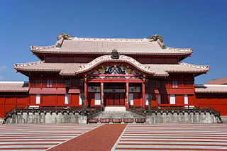
The Ryukyu Kingdom was a kingdom in the Ryukyu Islands from 1429 to 1879. It was ruled as a tributary state of imperial Ming China by the Ryukyuan monarchy, who unified Okinawa Island to end the Sanzan period, and extended the kingdom to the Amami Islands and Sakishima Islands. The Ryukyu Kingdom played a central role in the maritime trade networks of medieval East Asia and Southeast Asia despite its small size. The Ryukyu Kingdom became a vassal state of the Satsuma Domain of Japan after the invasion of Ryukyu in 1609 but retained de jure independence until it was transformed into the Ryukyu Domain by the Empire of Japan in 1872. The Ryukyu Kingdom was formally annexed and dissolved by Japan in 1879 to form Okinawa Prefecture, and the Ryukyuan monarchy was integrated into the new Japanese nobility.

The Japanese archipelago is an archipelago of 14,125 islands that form the country of Japan. It extends over 3,000 km (1,900 mi) from the Sea of Okhotsk in the northeast to the East China and Philippine seas in the southwest along the Pacific coast of the Eurasian continent, and consists of three island arcs from north to south: the Northeastern Japan Arc, the Southwestern Japan Arc, and the Ryukyu Island Arc. The Daitō Islands, the Izu–Bonin–Mariana Arc, the Kuril Islands, and the Nanpō Islands neighbor the archipelago.

The Yaeyama Islands are an archipelago in the southwest of Okinawa Prefecture, Japan, and cover 591.46 square kilometres (228.36 sq mi). The islands are located southwest of the Miyako Islands, part of the Ryukyu Islands archipelago. The Yaeyama Islands are the remotest part of Japan from the main islands and contain Japan's most southern (Hateruma) and most western (Yonaguni) inhabited islands. The city of Ishigaki serves as the political, cultural, and economic center of the Yaeyama Islands. On maps dating to the 1700s, the Yaeyama Group of Islands appears as the "Majico Sima Group", "Nambu-soto Islands", "Nambu Soto", and the "Taipin Islands".

Liuqiu, also known by several other names, is a coral island in the Taiwan Strait about 13 kilometers (8 mi) southwest of the main island of Taiwan. It has an area of 6.8 km2 (2.6 sq mi) and approximately 12,200 residents, the vast majority of whom share only 10 surnames. It is administered as a township of Pingtung County in Taiwan Province, Republic of China. As of 2019 the township chief is Chen Lung-chin.
Liuqiu or Lewchew was a realm said to have existed in the East China Sea. During the 18th and 19th centuries, it was referred to as Liukiu in English; and, Lieou-kieou in French. Referenced in various historical Chinese texts such as the Book of Sui, it is variously identified with Taiwan Island, the Penghu Islands, and the Ryukyu Islands.

The Japanese punitive expedition to Taiwan in 1874, referred to in Japan as the Taiwan Expedition and in Taiwan and Mainland China as the Mudan incident, was a punitive expedition launched by the Japanese ostensibly in retaliation for the murder of 54 Ryukyuan sailors by Paiwan aborigines near the southwestern tip of Taiwan in December 1871. In May 1874, the Imperial Japanese Army and Imperial Japanese Navy attacked the indigenous Taiwanese peoples in southern Taiwan and retreated in December after the Qing dynasty agreed to pay an indemnity of 500,000 taels, with Japan conceding that China had sovereignty over Taiwan. Some ambiguous wording in the agreed terms were later argued by Japan to be confirmation of Chinese renunciation of suzerainty over the Ryukyu Islands, paving the way for de facto Japanese incorporation of the Ryukyu in 1879.

The Ryukyu independence movement or the Republic of the Ryukyus is a political movement advocating for the independence of the Ryukyu Islands from Japan.

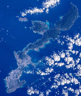
The Ryukyu Islands, also known as the Nansei Islands or the Ryukyu Arc, are a chain of Japanese islands that stretch southwest from Kyushu to Taiwan: the Ōsumi, Tokara, Amami, Okinawa, and Sakishima Islands, with Yonaguni the westernmost. The larger are mostly volcanic islands and the smaller mostly coral. The largest is Okinawa Island.
Shō Hashi was the last King of Chūzan and the first king of the Ryukyu Kingdom, uniting the three polities of Chūzan, Hokuzan, and Nanzan by conquest and ending the Sanzan period.
Eiso was a semi-legendary ruler of Okinawa Island. He was the founding monarch of the Eiso dynasty.
Gyorin was a neo-Confucian term developed in Joseon Korea. The term was intended to identify and characterize a diplomatic policy which establishes and maintains amicable relations with neighboring states. It was construed and understood in tandem with a corollary term, which was the sadae or "serving the great" policy towards Imperial China.
The Ryukyu Islands are a volcanic arc archipelago.

The Ryukyu Domain was a short-lived domain of the Empire of Japan, lasting from 1872 to 1879, before becoming the current Okinawa Prefecture and other islands at the Pacific edge of the East China Sea.
Okinawa (沖縄) is a name with multiple referents. The endonym refers to Okinawa Island in southwestern Japan. Today it can cover some surrounding islands and, more importantly, can refer to Okinawa Prefecture, a much larger administrative division of Japan, although the people from the Miyako and Yaeyama Islands still feel a strong sense of otherness to Okinawa.
The Hyōtō Ryūkyū-koku ki (漂到流球国記) was a book written by Japanese Buddhist monk Keisei in 1244. He interviewed travelers who, during a sea voyage to Song China, drifted to what they believed to be Ryūkyū. It reflects the long-lasting Japanese perception of Ryūkyū as the land of man-eating demons.
The earliest confirmed descriptions of visits by Han Chinese people to Taiwan occurred during the Yuan dynasty (1271–1368) and Chinese objects such as pottery were found there, suggesting trade between Taiwanese indigenous peoples and the Han Chinese in prior periods. Trade between Han and Taiwanese indigenous peoples increased during the Ming dynasty (1368–1644). Pirates and fishermen also started visiting Taiwan. By the early 17th century, there were 1,500–2,000 Han people inhabiting one or two villages in southwestern Taiwan. Most of them were engaged in seasonal fishing and left afterwards but some stayed and planted crops.