
The Arctic Archipelago, also known as the Canadian Arctic Archipelago, is an archipelago lying to the north of the Canadian continental mainland, excluding Greenland and Iceland.

The Nimrod Glacier is a major glacier about 135 km (85 mi) long, flowing from the polar plateau in a northerly direction through the Transantarctic Mountains into the Ross Ice Shelf, Antarctica.

The Priestley Glacier is a major valley glacier, about 60 nautical miles long, originating at the edge of the Polar Plateau of Victoria Land, Antarctica. The glacier drains southeast between the Deep Freeze Range and Eisenhower Range to enter the northern end of the Nansen Ice Sheet. It was first explored by the Northern Party of the British Antarctic Expedition, 1910–13, and named for Raymond Priestley, a geologist with the Northern Party.

Vanderford Glacier is a glacier about 8 km (5 mi) wide flowing northwest into the southeast side of Vincennes Bay, slightly south of the Windmill Islands. It was named by the Advisory Committee on Antarctic Names (US-ACAN) for Benjamin Vanderford, pilot of the sloop of war Vincennes of the United States Exploring Expedition under Captain Wilkes, 1838–42. The glacier was mapped from aerial photographs taken by U.S. Navy Operation Highjump, 1946–47.
Chuschi is a town in the Chuschi District of the Cangallo Province of the Ayacucho Region of Peru. On May 17, 1980, Shining Path guerrillas began their war against the Peruvian state by burning ballot boxes in Chuschi. On March 14, 1991, government forces perpetrated the Chuschi massacre in the town.

Underwood Glacier is a channel glacier in Wilkes Land, Antarctica about 15 nautical miles long, flowing to the Antarctic coast between Reist Rocks and Cape Nutt. It was mapped in 1955 by G. D. Blodgett from aerial photographs taken by U.S. Navy Operation Highjump in 1947 and named by Advisory Committee on Antarctic Names (US-ACAN) after Lieutenant Thomas Joseph Underwood, Jr., USMC, who served on the sloop Vincennes of the United States Exploring Expedition (1838–42) under Lieutenant Charles Wilkes.

El Piñero is a municipality located in the province of Zamora, Castile and León, Spain. According to the 2004 census (INE), the municipality has a population of 282 inhabitants.
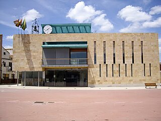
Pedrajas de San Esteban is a municipality located in the province of Valladolid, Castile and León, Spain. According to the 2004 census (INE), the municipality has a population of 3,317 inhabitants.
Sillard Islands is a group of small ice-covered islands lying close to Cape Mascart, the northeast extremity of Adelaide Island. Discovered by the French Antarctic Expedition, 1908–10, under Charcot, and named for Director Sillard of the French Montevideo Co., Montevideo, Uruguay, whose company made repairs on Charcot's ship, the Pourquoi Pas ?.

Pontal do Paraná is a municipality in the state of Paraná in the Southern Region of Brazil.
Cape Casey is a conspicuous cape surmounted by a peak 755 metres (2,480 ft) high, marking the east end of the peninsula projecting into Cabinet Inlet immediately south of Bevin Glacier, on the east coast of Graham Land. It was charted by the Falkland Islands Dependencies Survey (FIDS) and photographed from the air by the Ronne Antarctic Research Expedition in 1947. It was named by the FIDS for Rt. Hon. Richard G. Casey, Minister of State and Australian member of the British War Cabinet.
Challenger Island is an island lying just north of Murray Island, off the west coast of Graham Land. The name was used in 1906 by J. Gunnar Andersson of the Swedish Antarctic Expedition under Otto Nordenskiöld, 1901–04.
Palestrina Glacier is a glacier lying in the northern portion of Alexander Island, Antarctica, 11 nautical miles (20 km) long and 8 nautical miles (15 km) wide, flowing west from Nichols Snowfield into Lazarev Bay. The glacier was mapped from air photos taken by the Ronne Antarctic Research Expedition (RARE), 1947–48, by Derek J.H. Searle of the Falkland Islands Dependencies Survey (FIDS) in 1960. Named by the United Kingdom Antarctic Place-Names Committee (UK-APC) for Giovanni da Palestrina (1525–1594), Italian composer.

Madell Point is a point 2 nautical miles (4 km) northeast of Cape Rey on the northwest coast of Pernik Peninsula, on the Loubet Coast of Graham Land, Antarctica. It was mapped from air photos taken by the Falkland Islands and Dependencies Aerial Survey Expedition (1956–57), and was named for James S. Madell, a Falkland Islands Dependencies Survey surveyor at Detaille Island in 1957, who was responsible for the triangulation of this area.
Snowshoe Glacier is a glacier 8 nautical miles (15 km) long flowing west from a col in the southwest flank of Neny Glacier into Neny Fjord, western Graham Land. Roughly surveyed from the ground (1936) and photographed from the air (1937) by British Graham Land Expedition (BGLE). Surveyed by Falkland Islands Dependencies Survey (FIDS) in 1949. The name was suggested by K.S.P. Butler of the FIDS in 1948 because the shape of the glacier with its narrow head and wide mouth resembles a snowshoe.
Squires Glacier is a tributary glacier between the Playfair and Hutton Mountains, flowing east-northeast to Swann Glacier, in Palmer Land. Mapped by United States Geological Survey (USGS) from surveys and U.S. Navy air photos, 1961–67. Named by Advisory Committee on Antarctic Names (US-ACAN) for Peter L. Squires, glaciologist at Byrd Station, summer 1965–66.
Tofani Glacier is a glacier flowing northeast into the head of Solberg Inlet, Bowman Coast, to the north of Houser Peak. The feature was photographed from the air by United States Antarctic Service (USAS), 1940, U.S. Navy, 1966, and was surveyed by Falkland Islands Dependencies Survey (FIDS), 1946–48. Named by Advisory Committee on Antarctic Names (US-ACAN) in 1977 after Dr. Walter Tofani, M.D., station physician at Palmer Station, 1975.