Livingston's Hideout

Last updated
Livingston's Hideout
Cherokee County, Kansas
Coordinates 37°01′31″N94°37′16″W / 37.0253°N 94.6210°W / 37.0253; -94.6210 Coordinates: 37°01′31″N94°37′16″W / 37.0253°N 94.6210°W / 37.0253; -94.6210
Type guerrilla hideout
Site information
Controlled by Confederate guerrillas
Site history
Built ca. spring 1862
In use ca. spring 1862 to ca. summer 1863
Garrison information
Past
commanders
Major Thomas R. Livingston
Garrison same

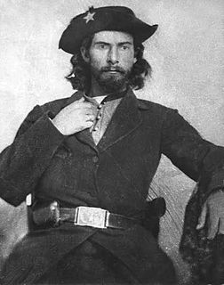
Livingston's Hideout was most likely the only permanent Confederate military camp inside Kansas during the Civil War. It was in the very corner of southeast Kansas, in the very corner of Cherokee County, Kansas. It was about 2 miles (3.2 km) north of the border with Indian Territory and it was less than 100 feet (30 m) west of the border with Missouri. It was 5 miles (8.0 km) west of Baxter Springs, where a series of Union military posts existed from 1862 to 1863. Thomas R. Livingston became a leader of a group of Confederate guerrillas in the area, becoming first a captain and then a major. He needed locations to hide himself and his guerrillas from pursuing Union troops and this hideout suited the guerrillas well. The guerrillas sought to spy on Union forces and raiding units he found small enough to defeat. [1] [2]

A military camp or bivouac is a semi-permanent facility for the lodging of an army. Camps are erected when a military force travels away from a major installation or fort during training or operations, and often have the form of large campsites.

Kansas State of the United States of America

Kansas is a U.S. state in the Midwestern United States. Its capital is Topeka and its largest city is Wichita, with its most populated county being Johnson County. Kansas is bordered by Nebraska on the north; Missouri on the east; Oklahoma on the south; and Colorado on the west. Kansas is named after the Kansas River, which in turn was named after the Kansa Native Americans who lived along it banks. The tribe's name is often said to mean "people of the (south) wind" although this was probably not the term's original meaning. For thousands of years, what is now Kansas was home to numerous and diverse Native American tribes. Tribes in the eastern part of the state generally lived in villages along the river valleys. Tribes in the western part of the state were semi-nomadic and hunted large herds of bison.

American Civil War Civil war in the United States from 1861 to 1865

The American Civil War was a war fought in the United States from 1861 to 1865, between the North and the South. The Civil War is the most studied and written about episode in U.S. history. Primarily as a result of the long-standing controversy over the enslavement of black people, war broke out in April 1861 when secessionist forces attacked Fort Sumter in South Carolina shortly after Abraham Lincoln had been inaugurated as the President of the United States. The loyalists of the Union in the North proclaimed support for the Constitution. They faced secessionists of the Confederate States in the South, who advocated for states' rights to uphold slavery.

No one knows when Livingston found his hideout, but he possibly began using it in spring 1862. No Union troops knew of its existence during the Civil War. The campsite was in a heavily wooded area. A road runs just west of the campsite and is about 100 feet (30 m) above it. The area of the campsite cannot be seen from the road, as it is in the woods and the area beyond the road drops off sharply before the camp begins. The site is flat and somewhat oval shaped. It is 100 feet (30 m) wide and 200 feet (61 m) long. A creek is about 50 feet (15 m) below the campsite and a hill to the east, inside Missouri, is on the east side of the creek, about 50 feet (15 m) above the campsite. The creek runs through a long valley. This camp would have been almost in plain sight, yet invisible. [3]

The use of Livingston's hideout proved a great frustration for the area's Union troops. Many times the troops chased the guerrillas, only to have them scatter and seemingly vanish. The hideout was used at least July 1863, when Livingston was killed in a fight with Union troops in Stockton, Missouri. After its use ceased, it was not rediscovered until after the War. Eventually, in the 1980s someone decided to build a house there and Betty Kyrias, of the Baxter Springs Historical Society, discovered the site yet again. [4] [5]

Stockton, Missouri City in Missouri, United States

Stockton is a city in Cedar County, Missouri, United States. The population was 1,819 at the 2010 census. It is the county seat of Cedar County.

Related Research Articles

Border states (American Civil War) slave states that had not declared a secession from the Union during the American Civil War

In the context of the American Civil War (1861–65), the border states were slave states that did not declare a secession from the Union and did not join the Confederacy. To their north they bordered free states of the Union and to their south they bordered Confederate slave states. Of the 34 U.S. states in 1861, nineteen were free states and fifteen were slave states. Two slave states never declared a secession or adopted an ordinance: Delaware and Maryland. Four others did not declare secession until after the Battle of Fort Sumter and were briefly considered to be border states: Arkansas, North Carolina, Tennessee and Virginia—after this, they were less frequently called "border states". Also included as a border state during the war is West Virginia, which was formed from 50 counties of Virginia and became a new state in the Union in 1863.

Quantrill's Raiders were the best-known of the pro-Confederate partisan guerrillas who fought in the American Civil War. Their leader was William Quantrill and they included Jesse James and his brother Frank.

Battle of Baxter Springs Battle and massacre of the American Civil War

The Battle of Baxter Springs, more commonly known as the Baxter Springs Massacre, was a minor battle of the American Civil War fought on October 6, 1863, near the present-day town of Baxter Springs, Kansas.

William T. Anderson American guerrilla fighter

William T. Anderson, known by the nickname "Bloody Bill" Anderson, was one of the deadliest and most notorious pro-Confederate guerrilla leaders in the American Civil War. Anderson led a band of volunteer partisan rangers that targeted Union loyalists and federal soldiers in the states of Missouri and Kansas.

Trans-Mississippi Theater of the American Civil War

The Trans-Mississippi Theater of the American Civil War consists of the major military operations west of the Mississippi River. The area is often thought of as excluding the states and territories bordering the Pacific Ocean, which formed the Pacific Coast Theater of the American Civil War (1861-1865).

Kansas in the American Civil War

At the outbreak of the American Civil War in April 1861, Kansas was the newest U.S. state, admitted just months earlier in January. The state had formally rejected slavery by popular vote and vowed to fight on the side of the Union, though ideological divisions with neighboring Missouri, a slave state, had led to violent conflict in previous years and persisted for the duration of the war.

Skirmish at Island Mound American Civil War skirmish

The Skirmish at Island Mound was a skirmish of the American Civil War, occurring on October 29, 1862, in Bates County, Missouri. The Union victory is notable as the first known event in which an African-American regiment engaged in combat against Confederate forces during the war.

Indian Territory in the American Civil War

During the American Civil War, most of what is now the U.S. state of Oklahoma was designated as the Indian Territory. It served as an unorganized region that had been set aside specifically for Native American tribes and was occupied mostly by tribes which had been removed from their ancestral lands in the Southeastern United States following the Indian Removal Act of 1830. As part of the Trans-Mississippi Theater, the Indian Territory was the scene of numerous skirmishes and seven officially recognized battles involving both Native American units allied with the Confederate States of America and Native Americans loyal to the United States government, as well as other Union and Confederate troops.

Fort Baxter, also known as Fort Blair, was a small US Army post located in the southeast corner of Kansas near present-day Baxter Springs. This area was known as the Cherokee Strip. It was one of a few Kansas forts attacked by Confederate forces during the American Civil War. At one point the Confederate government claimed authority over the Neutral Lands. Both Union and Confederate troops operated in the area, as did guerrilla forces and militias prevalent in the Kansas-Missouri border area.

Kansas has always been home to many forts and military posts.

On March 7, 1862, Confederate guerrillas under William C. Quantrill raided the small Kansas town of Aubry, southwest of Kansas City, Missouri, and just west of the Kansas-Missouri border. Three residents were killed in the raid and much property was carted away by the guerrillas.

In 1862 the citizens of Burlingame, Kansas, constructed a stone fort around the town well, in an intersection in the business district. This was done to prevent the burning of Burlingame by Confederate guerrilla William Anderson, later known as Bloody Bill Anderson. He and his family had lived in a neighboring county up to 1862, but Anderson got into considerable trouble and was forced to leave. Upon leaving, Anderson threatened to burn Burlingame.

In early May 1863 a temporary camp, Camp Hooker, was established at the site of what later became Baxter Springs, Kansas. This area was located in what was known as the Cherokee Strip (Kansas). In late May while the camp commander, Col. James M. Williams, was in Fort Scott, the troops moved the camp three blocks to the east to what is now Washington School Hill. The new camp, Camp Ben Butler (named after Maj. Gen. Benjamin Butler, was in a highly defendable position. It occupied a plateau that covered more than two square blocks. Only a small area to the south allowed easy access to camp. In fact, much of the surrounding area was practically impenetrable by men or horses.

Camp Defiance was a military encampment in eastern Kansas, U.S., during 1861–1862. In December 1861, the town of Potosi, Kansas, along the Kansas-Missouri border, was attacked by Confederate guerrillas. Very soon Col. James Montgomery stationed the Kansas 3rd Regiment about 4 miles (6 km) to the northeast.

Camp Hunter was established in June 1862 or a bit earlier at what is now Baxter Springs, Kansas. It was established by Union troops. At the same time Indian Home Guard regiments established a camp nearby on Little Five Mile Creek.

In June 1862 two Union camps were established in the vicinity of what is today Baxter Springs, Kansas. One was Camp Hunter, located in what is now the center of the town. The other was the Indian Home Guard Camp, located at Little Five Mile Creek, 1½ miles southeast of Camp Hunter.

During the Civil War, Coldwater Grove existed 13½ miles east of Paola, Kansas. It straddled the Kansas-Missouri border, being partly in both states. About June 1863 a Union military post was established on the Kansas side of the community and the post was put under the command of Lt. Col. Charles S. Clark. Clark also commanded four nearby posts.

Fort Lincoln was established about August 24, 1861, by United States Senator James Lane. Earlier in August, Lane had reestablished Fort Scott as a military post. Soon Confederate troops under Maj. Gen. Sterling Price threatened to overrun the newly reopened post.

Fort McKean is a fort located inside Kansas along the Kansas-Missouri border. On November 14, 1862, Company C of the 3rd Wisconsin Cavalry, led by Lieut. James B. Pond, established a camp at Morris Mills on Drywood Creek. It was fifteen miles southeast of Fort Scott. Sometime later this camp was given the name of Fort McKean. The post was probably on the Fort Scott-Fort Gibson Military Road, and many, including Pond, thought the post was inside Missouri. Throughout its history, Fort McKean was a small post, ranging in strength from 20 to 60 men. It is unknown what buildings or defenses were erected there.

Paola's post, sometimes called Post Paola, in Miami County, Kansas, was located on the west side of Bull Creek, just west of Paola, Kansas. It was probably established in December 1861, as that was the first time it was mentioned. This post became one of the more important posts along the Kansas-Missouri border during the Civil War. It became a district headquarters in 1863. Later, in September 1864, it was designated a subdistrict headquarters, when the district headquarters was moved to Lawrence, Kansas. The military road from Fort Leavenworth to Fort Gibson ran through Paola, thus ensuring the post always had some importance.

References

  1. Betty F. Kyrias, letter to William C. Pollard, Jr., April 1, 1993, pp. 3-4.
  2. Pollard, "Forts and Military Posts in Kansas: 1854-1865" (Ph.D. dissertation, Faith Baptist College and Seminary, 1997), p. 125. A copy of this dissertation can be found in the Manuscript Div. of the Kansas State Historical Society, Topeka, Kans.
  3. Kyrias, "The Civil War in Baxter Springs, Kansas, 1862-3" (Baxter Springs, Kans.: Baxter Springs Historical Society, August 8, 1988), pp. 1-3.
  4. Kyrias, letter to Pollard, p. 1.
  5. Charles Sheppard, report, The War of the Rebellion (Washington: Government Printing Office, 1888), Series I, Vol. XXII, Part I, p. 445.