Related Research Articles

Bon Homme County is a county in the U.S. state of South Dakota. As of the 2020 census, the population was 7,003. Its county seat is Tyndall.

Chouteau County is a county located in the North-Central region of the U.S. state of Montana. As of the 2020 census, the population was 5,895. Its county seat is Fort Benton. The county was established in 1865 as one of the original nine counties of Montana, and named in 1882 after Pierre Chouteau Jr., a fur trader who established a trading post that became Fort Benton, which was once an important port on the Missouri River.

Bingham County is a county in the U.S. state of Idaho. As of the 2020 census, the population was 47,992. The county seat and largest city is Blackfoot.

New Boston is an unincorporated community in Wayne County in the U.S. state of Michigan. The community is located within Huron Charter Township. As an unincorporated community, New Boston has no legally defined boundaries or population statistics of its own.

Google Maps is a web mapping platform and consumer application offered by Google. It offers satellite imagery, aerial photography, street maps, 360° interactive panoramic views of streets, real-time traffic conditions, and route planning for traveling by foot, car, bike, air and public transportation. As of 2020, Google Maps was being used by over one billion people every month around the world.

The Barkly Highway is a national highway in Queensland and the Northern Territory in Australia. It is the only sealed road between Queensland and the Northern Territory. The highway is named after the Barkly Tableland, which in turn was named by explorer William Landsborough in December 1861 after Henry Barkly, the then Governor of Victoria.
Google Earth is a computer program that renders a 3D representation of Earth based primarily on satellite imagery. The program maps the Earth by superimposing satellite images, aerial photography, and GIS data onto a 3D globe, allowing users to see cities and landscapes from various angles. Users can explore the globe by entering addresses and coordinates, or by using a keyboard or mouse. The program can also be downloaded on a smartphone or tablet, using a touch screen or stylus to navigate. Users may use the program to add their own data using Keyhole Markup Language and upload them through various sources, such as forums or blogs. Google Earth is able to show various kinds of images overlaid on the surface of the Earth and is also a Web Map Service client. In 2019, Google revealed that Google Earth now covers more than 97 percent of the world, and has captured 10 million miles of Street View imagery.

Aitkenvale is a suburb of Townsville in the City of Townsville, Queensland, Australia. In the 2021 census, Aitkenvale had a population of 4,797 people.

Murarrie is an eastern riverside mixed-use suburb in the City of Brisbane, Queensland, Australia. Queensport is a neighbourhood within Murarrie. Gibson Island is a neighbourhood within Murarrie and, despite its name, is no longer an island. In the 2021 census, Murarrie had a population of 4,946 people.

Trunk 10 is part of the Canadian province of Nova Scotia's system of Trunk Highways. This rural road runs from Bridgewater to Middleton, a distance of 88 kilometres (55 mi).

Trunk 16 is part of the Canadian province of Nova Scotia's system of Trunk Highways. The road runs from an intersection with Trunk 4 in Monastery to Canso, a distance of 79 kilometres (49 mi).

Trunk 22 is part of the Canadian province of Nova Scotia's system of trunk highways. The route runs from Sydney to Louisbourg, a distance of 36 kilometres (22 mi).
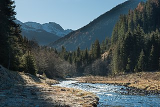
The Wattenbach or Wattenerbach is a river of Tyrol, Austria, a tributary of the Inn.

Route 480, also known as Burgeo Highway or The Burgeo Road, is a 150-kilometre-long (93 mi) north-south on southwestern Newfoundland in the Canadian province of Newfoundland and Labrador. It connects the town of Burgeo with the Trans-Canada Highway. The highway is a winding two-lane highway traveling through remote, hilly, and wooded terrain for its entire length. There are no other communities of any kind along the highway, with the only other intersections being abandoned logging roads. Route 480 also provides access to Sandbanks Provincial Park and ferries to the remote outports of Ramea, Grey River and Francois at its southern terminus. There are also several vacation/hunting camps along Route 480, including Peter Strides.
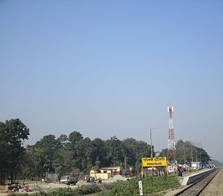
Pundibari is a village in the Cooch Behar II CD block in the Cooch Behar Sadar subdivision of the Cooch Behar district of West Bengal, India.
The following is a timeline for Google Street View, a technology implemented in Google Maps and Google Earth that provides ground-level interactive panoramas of cities. The service was first introduced in the United States on May 25, 2007, and initially covered only five cities: San Francisco, Las Vegas, Denver, Miami, and New York City. By the end of 2008, Street View had full coverage available for all of the major and minor cities in the continental United States, and had started expanding its scope to include some of the country's national parks, as well as cities elsewhere in the world. For the first year and a half of its existence, Street View featured camera icon markers, each representing at least one major city or area. By its 10th anniversary, the Street View service had provided imagery for more than 10 million miles' worth of roads across 83 countries worldwide.

The Wattentaler Lizum is the name of the head of the Wattental valley which branches off the lower Inn valley near Wattens. Lizum means "alpine pasture at the head of the valley" in Tyrolese. The Wattentaler Lizum lies at the eastern end of the valley in the municipality of Wattenberg.

Widgee is a rural locality in the Gympie Region, Queensland, Australia. In the 2021 census, Widgee had a population of 862 people.

Tamborine is a rural town in the Scenic Rim Region and a locality split between the Scenic Rim Region and the City of Logan in Queensland, Australia. In the 2021 census, the locality of Tamborine had a population of 4,388 people.

Tully Heads is a coastal town and locality in the Cassowary Coast Region, Queensland, Australia. In the 2021 census, the locality of Tully Heads had a population of 354 people.
References
- ↑ Google (22 March 2020). "Lizumbach source" (Map). Google Maps . Google. Retrieved 22 March 2020.
- ↑ Google (21 March 2020). "Lizumbach mouth" (Map). Google Maps . Google. Retrieved 21 March 2020.
- ↑ "From Lager Walchen". Whympr. Whympr mobile app. Retrieved 22 March 2020.
- ↑ "Tag 3: Lizumerhütte über Zirbenweg nach Wattenberg" (PDF) (in German). Almenrausch.at. Retrieved 22 March 2020.
| | This Tyrol location article is a stub. You can help Wikipedia by expanding it. |