
Snowdonia, or Eryri, is a mountainous region and national park in North Wales. It contains all 15 mountains in Wales over 3000 feet high, including the country's highest, Snowdon, which is 1,085 metres (3,560 ft) tall. These peaks are all part of the Snowdon, Glyderau, and Carneddau ranges in the north of the region. The shorter Moelwynion and Moel Hebog ranges lie immediately to the south.

Beddgelert is a village and community in the Snowdonia area of Gwynedd, Wales. The population of the community taken at the 2021 census was 460. This includes Nantmor and Nant Gwynant. It is reputed to be named after the legendary hound Gelert. The community is large and sparsely populated and covers 86 square kilometres.

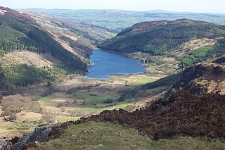
Dinas Emrys is a rocky and wooded hillock near Beddgelert in Gwynedd, north-west Wales. Rising some 76 m (250 ft) above the floor of the Glaslyn river valley, it overlooks the southern end of Llyn Dinas in Snowdonia.

Snowdon, or Yr Wyddfa, is a mountain in the Snowdonia region of North Wales. It has an elevation of 1,085 metres (3,560 ft) above sea level, which makes it both the highest mountain in Wales and the highest in the British Isles south of the Scottish Highlands. Snowdon is designated a national nature reserve for its rare flora and fauna, and is located within Snowdonia National Park.

The Welsh Highland Railway is a 25-mile (40.2 km) long, restored 1 ft 11+1⁄2 in narrow gauge heritage railway in the Welsh county of Gwynedd, operating from Caernarfon to Porthmadog, and passing through a number of popular tourist destinations including Beddgelert and the Aberglaslyn Pass. At Porthmadog it connects with the Ffestiniog Railway and to the short Welsh Highland Heritage Railway. In Porthmadog it uses the United Kingdom's only mixed gauge flat rail crossing.

Russell is a narrow gauge steam locomotive originally built in 1906 for the North Wales Narrow Gauge Railways (NWNGR), but most famously associated with the original Welsh Highland Railway (WHR), and now based at the Welsh Highland Heritage Railway in Porthmadog.

The Llanberis Pass in Snowdonia carries the main road (A4086) from the south-east to Llanberis, over Pen-y-Pass, between the mountain ranges of the Glyderau and the Snowdon massif. At the bottom of the pass is the small village of Nant Peris.

Llyn Cwellyn is a reservoir in North Wales which supplies drinking water to parts of Gwynedd and Anglesey. It lies on the Afon Gwyrfai in Nant y Betws between Moel Eilio and Mynydd Mawr in the northern part of Snowdonia National Park. It has an area of 215 acres (0.87 km2), and is over 120 ft (37 m) deep. At the southern end is the small village of Rhyd Ddu.

Afon Glaslyn is a river in Gwynedd, north-west Wales. While not of great significance in terms of its length, it is one of Gwynedd's primary rivers, and has greatly influenced the landscape in which it flows.

Llyn Cowlyd is the deepest lake in northern Wales. It lies in the Snowdonia National Park at the upper end of Cwm Cowlyd on the south-eastern edge of the Carneddau range of mountains, at a height of 330 metres (1,083 ft) above sea level. The lake is long and narrow, measuring nearly 3 kilometres (2 mi) long and about 500 m wide, and covers an area of 1.1 square kilometres. It has a mean depth of 33 metres (108 ft) and at its deepest has given soundings of 70 metres (230 ft), this being some 14 m (46 ft) greater than its natural depth, the water surface having been raised twice by the building of dams.
Llyn Crafnant is a lake that lies in a valley in Wales where the northern edge of the Gwydir Forest meets the lower slopes of the Carneddau mountains and, more specifically, the ridge of Cefn Cyfarwydd. The head of the valley offers a profile of crags which are silhouetted at sunset. The Forest Park guide (2002) states that "the is one of the most breathtaking views in all Snowdonia". The summits include Crimpiau 475 metres, and Craig Wen 548 metres which provide views to Moel Siabod and the Ogwen Valley, and Snowdon. Further up is Creigiau Gleision. At 63 acres (250,000 m2) it is the best part of a mile long, although it was clearly once much longer - its southern end shows the evidence of centuries of silting. Jehu's survey (see references) recorded a maximum depth of 71 ft (22 m).

Llyn Ogwen is a ribbon lake in north-west Wales. It lies alongside the A5 road between two mountain ranges of Snowdonia, the Carneddau and the Glyderau. Somewhat unusually, the county boundary at this point is drawn so that the lake itself lies in the county of Gwynedd, but all the surrounding land lies in Conwy County Borough.

Beddgelert railway station is a railway station on the narrow gauge Welsh Highland Railway in North Wales.

Nant Gwynant is a valley in northern Wales. The A498 road descends 600 feet (180 m) into the valley in about two miles (3 km) from Pen-y-Gwryd; it follows the Nant Cynnyd, the Afon Glaslyn and alongside Llyn Gwynant, then beside the Nant Gwynant river to Llyn Dinas and passing below Dinas Emrys to Beddgelert. The road continues through the Aberglaslyn Pass to Porthmadog.

Arfon was a mediaeval Welsh cantref in north-west Wales. It was the core of the kingdom of Gwynedd. Later it was included in the new county of Caernarfonshire, together with Llŷn and Arllechwedd under the terms of the Statute of Rhuddlan in 1284. The island of Anglesey faced it across the Menai Strait; to the east was the cantref of Arllechwedd, to the south the cantref of Eifionydd, and to the west was the cantref of Llŷn.
Lewys Daron was a Welsh-language professional poet from the Llŷn area of Gwynedd, Wales. Although not considered to be one of the foremost of the Poets of the Nobility, his work provides a portrait of the gentry society of north-west Wales at the start of the Tudor period.
Hugh Beaver Roberts was a solicitor, originally based in Bangor, Caernarfonshire who became an entrepreneur involved in the construction of narrow gauge railways and the ownership of slate quarries in North Wales during the second half of the 19th century.


