
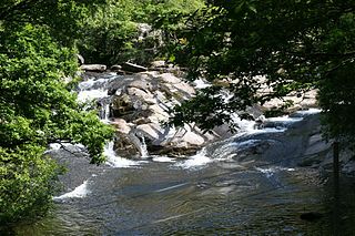
The River Conwy is a river in northern Wales. From its source to its discharge in Conwy Bay it is 55 kilometres (34 mi) long and drains an area of 678 square km. "Conwy" was formerly anglicised as "Conway."
ˈ The Afon Ogwen is a river in north-west Wales draining from some of the greatest peaks in Snowdonia before discharging to the sea on the eastern side of Bangor, Gwynedd.

Llyn Brenig is a reservoir located on Denbigh Moors in North Wales. The artificial lake, which was constructed between 1973 and 1976, was created by building an embankment dam across the Afon Brenig valley. It lies at 1,200 ft (370 m) above sea level on the border between the counties of Conwy and Denbighshire. It is used to manage the flow in the River Dee as part of the River Dee regulation system.

Llyn Padarn is a glacially formed lake in Snowdonia, Gwynedd, north Wales, and is an example of a moraine dammed lake. The lake is approximately 2 miles (3.2 km) long and at its deepest point is 94 feet (29 m) deep, and is one of the largest natural lakes in Wales. At its south-eastern end it is linked to the neighbouring Llyn Peris. The busy village of Llanberis lies on the southern banks of the lake.

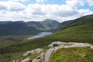
Llyn Cowlyd is the deepest lake in northern Wales. It lies in the Snowdonia National Park at the upper end of Cwm Cowlyd on the south-eastern edge of the Carneddau range of mountains, at a height of 1,164 feet (355 m) above sea level. The lake is long and narrow, measuring nearly 2 miles (3 km) long and about a third of a mile wide, and covers an area of 269 acres (1.1 km2). It has a mean depth of 109 feet (33 m) and at its deepest has given soundings of 229 feet (70 m), this being some 45 ft (14 m) greater than its natural depth, the water surface having been raised twice by the building of dams.
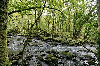
Llyn Crafnant is a lake that lies in a valley in Wales where the northern edge of the Gwydir Forest meets the lower slopes of the Carneddau mountains and, more specifically, the ridge of Cefn Cyfarwydd. The head of the valley offers a profile of crags which are silhouetted at sunset. The Forest Park guide (2002) states that "the is one of the most breathtaking views in all Snowdonia". The summits include Crimpiau 475 metres, and Craig Wen 548 metres which provide views to Moel Siabod and the Ogwen Valley, and Snowdon. Further up is Creigiau Gleision. At 63 acres (250,000 m2) it is the best part of a mile long, although it was clearly once much longer - its southern end shows the evidence of centuries of silting. Jehu's survey (see references) recorded a maximum depth of 71 ft (22 m).

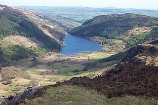
Llyn Ogwen is a ribbon lake in north-west Wales. It lies alongside the A5 road between two mountain ranges of Snowdonia, the Carneddau and the Glyderau. Somewhat unusually, the county boundary at this point is drawn so that the lake itself lies in the county of Gwynedd, but all the surrounding land lies in Conwy County Borough.

The Black Mountain is a mountain range in South, Mid and West Wales, straddling the county boundary between Carmarthenshire and Powys and forming the westernmost range of the Brecon Beacons National Park. Its highest point is Fan Brycheiniog at 802 metres or 2,631 ft. The Black Mountain also forms a part of the Fforest Fawr Geopark.

Llyn Peris is a lake in Snowdonia, Wales, approximately 1.8 km long and situated close to the villages of Llanberis and Nant Peris, and the smaller twin of Llyn Padarn. The lake was formed glacially and is an example of a moraine-dammed lake. Llyn Peris is named after Saint Peris, an early Christian saint of whom little is known. The lake is flanked on one side by the mountain Elidir Fawr and the former slate quarry of Dinorwig. Above the opposite bank are the hills of Derlwyn and Clogwyn Mawr and a rock formation known as the Lady of Snowdon, due to its resemblance to a human face. The ruins of Dolbadarn Castle are also located on a mound above the lake.

Caerhun is a scattered rural community, and former civil parish, on the west bank of the River Conwy. It lies to the south of Henryd and the north of Dolgarrog, in Conwy County Borough, Wales, and includes several small villages and hamlets including Llanbedr-y-cennin, Rowen, Tal-y-bont and Ty'n-y-groes. It was formerly in the historic county of Caernarvonshire. At the 2001 census, it had a population of 1,200, increasing to 1,292 at the 2011 census. It includes a large part of the Carneddau range including the lakes of Llyn Eigiau, Llyn Dulyn and Llyn Melynllyn.
Llyn Eigiau is a lake on the edge of the Carneddau range of mountains in Snowdonia, Conwy, Wales. The name Eigiau is thought to refer to the shoals of fish which once lived here. Early maps refer to it as Llynyga. It is thought that a small number of Arctic char exist in the lake after they were transferred here from Llyn Peris, and certainly it is one of the few lakes in Wales to have its own natural brown trout. The lake is surrounded by mountains including Pen Llithrig y Wrach.

Llyn Dulyn is a lake on the edge of the Carneddau range of mountains in Snowdonia, North Wales. The lake is 33 acres (130,000 m2) in extent and 189 feet deep. Less than a kilometre to its south lies the smaller Llyn Melynllyn. Cliffs rise steeply from the lake edge up to the summits of Garnedd Uchaf and Foel Grach, giving it a dark brooding appearance - hence its name.
Afon Ddu is the name of several rivers in Snowdonia in north-west Wales:

Afon Dulyn is the outflow from Llyn Dulyn, a lake in the Carneddau mountains in north-west Wales. It is a tributary of the river Conwy.
Afon Melynllyn is the outflow from Llyn Melynllyn, a lake in the Carneddau mountains in north-west Wales. It is a tributary of Afon Dulyn, itself a tributary of the river Conwy.
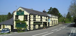
Tal-y-Cafn is a small settlement in Conwy county borough, north Wales, in the community of Eglwysbach.

The River Dysynni is a river in mid Wales. Its source is the Tal-y-llyn Lake just south of the Cadair Idris massif and its mouth is in the Cardigan Bay area of the Irish Sea to the north of Tywyn. It measures about 16 mi (26 km) in length.
The Afon Ysgethin is a short river in Gwynedd, Wales. Flowing entirely within Snowdonia National Park it rises beneath the peaks of Y Llethr and Diffwys within the Rhinogs mountain range and runs in a generally ESE direction towards Cardigan Bay.

