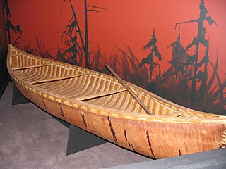
A canoe is a lightweight narrow water vessel, typically pointed at both ends and open on top, propelled by one or more seated or kneeling paddlers facing the direction of travel and using paddles.

Ely is a city in Saint Louis County, Minnesota, United States. The population was 3,268 at the 2020 census.

A coureur des bois or coureur de bois were independent entrepreneurial French Canadian traders who travelled in New France and the interior of North America, usually to trade with First Nations peoples by exchanging various European items for furs. Some learned the trades and practices of the indigenous peoples.

The Pigeon River forms part of the Canada–United States border between the state of Minnesota and the province of Ontario, west of Lake Superior. In pre-industrial times, the river was a waterway of great importance for transportation and the fur trade.

The Boundary Waters Canoe Area Wilderness comprises 1,090,000 acres (440,000 ha) of pristine forests, glacial lakes, and streams in the Superior National Forest. Located entirely within the U.S. state of Minnesota at the Boundary Waters, the wilderness area is under the administration of the United States Forest Service. Efforts to preserve the primitive landscape began in the 1900s and culminated in the Boundary Waters Canoe Area Wilderness Act of 1978. The area is a popular destination for canoeing, hiking, and fishing, and is the most visited wilderness in the United States.

Lake Nipissing is a lake in the Canadian province of Ontario. It has a surface area of 873.3 km2 (337.2 sq mi), a mean elevation of 196 m (643 ft) above sea level, and is located between the Ottawa River and Georgian Bay. Lake Nipissing is the third-largest lake entirely in Ontario. It is relatively shallow for a large lake, with an average depth of only 4.5 m (15 ft). The shallowness of the lake makes for many sandbars along the lake's irregular shoreline. The lake reaches a maximum depth of 64 m (210 ft) near the mouth of the French River, off the shore of Blueberry Island. The lake has many islands most of which are protected under the Protection of Significant Wetlands scheme, controlled by the Ministry of Natural Resources and Forestry.

The Mattawa River is a river in central Ontario, Canada. It flows east from Trout Lake east of North Bay and enters the Ottawa River at the town of Mattawa. Counting from the head of Trout Lake, it is 76 kilometres (47 mi) long. The river's name comes from the Algonquin word for "meeting of waterways".

Voyageurs National Park is a national park of the United States in northern Minnesota established in 1975. It is located near the city of International Falls. The park's name commemorates the voyageurs—French-Canadian fur traders who were the first European settlers to frequently travel through the area. Notable for its outstanding water resources, the park is popular with canoeists, kayakers, other boaters, and fishermen. The Kabetogama Peninsula, which lies entirely within the park and makes up most of its land area, is accessible only by boat. To the east of the park lies the Boundary Waters Canoe Area Wilderness.

Canoe camping, also known as touring, tripping or expedition canoeing, is a combination of canoeing and camping. Canoe campers typically carry enough supplies with them to travel and camp for several days via a canoe.

Quetico Provincial Park is a large wilderness park in Northwestern Ontario, Canada, known for its excellent canoeing and fishing. The 4,760 km2 (1,180,000-acre) park shares its southern border with Minnesota's Boundary Waters Canoe Area Wilderness, which is part of the larger Superior National Forest. These large wilderness parks are often collectively referred to as the Boundary Waters or the Quetico-Superior Country.

Mattawa is a town in northeastern Ontario, Canada at the confluence of the Mattawa and Ottawa Rivers in Nipissing District. The first Europeans to pass through this area were Étienne Brûlé and Samuel de Champlain.

Grand Portage National Monument is a United States National Monument located on the north shore of Lake Superior in northeastern Minnesota that preserves a vital center of fur trade activity and Anishinaabeg Ojibwe heritage. The area became one of the British Empire's four main fur trading centers in North America, along with Fort Niagara, Fort Detroit, and Michilimackinac.

Jay Cooke State Park is a state park of Minnesota, United States, protecting the lower reaches of the Saint Louis River. The park is located about 10 miles (16 km) southwest of Duluth and is one of the ten most visited state parks in Minnesota. The western half of the park contains part of a rocky, 13-mile (21 km) gorge. This was a major barrier to Native Americans and early Europeans traveling by canoe, which they bypassed with the challenging Grand Portage of the St. Louis River. The river was a vital link connecting the Mississippi waterways to the west with the Great Lakes to the east.
La Verendrye Provincial Park is a waterway provincial park located in Ontario, Canada, on the border with the U.S. state of Minnesota. The park stretches from Quetico Provincial Park through Saganaga Lake, up the Pine River, across the Height of Land Portage, then down the Pigeon River to Pigeon River Provincial Park on Lake Superior. The park is named after Pierre Gaultier de Varennes, sieur de La Vérendrye, an early explorer of Canada.
The Fur Trade at Lachine National Historic Site is a historic building located in the borough of Lachine in Montreal, Quebec, Canada, at the western end of the Lachine Canal. It is a National Historic Site of Canada.
Height of Land Portage is a portage along the historic Boundary Waters route between Canada and the United States. Located at the border of the Canadian province of Ontario and the U.S. state of Minnesota, the path is a relatively easy crossing of the Laurentian Divide separating the Hudson Bay and Great Lakes-St. Lawrence watersheds.

This article covers the water based Canadian canoe routes used by early explorers of Canada with special emphasis on the fur trade.
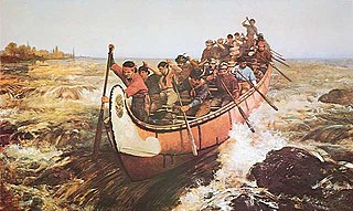
Voyageurs were 18th- and 19th-century French and later French Canadians and others who transported furs by canoe at the peak of the North American fur trade. The emblematic meaning of the term applies to places and times where that transportation was over long distances, giving rise to folklore and music that celebrated voyageurs' strength and endurance. They traversed and explored many regions in what is now Canada and the United States.
In North American history, a rendezvous was a larger meeting held typically once per year in the wilderness. All types included a major transfer of furs and goods to be traded for furs. Variations included a mix of other types of trading, business transactions, business meetings, and revelry.
Abitibi-De-Troyes Provincial Park is in Cochrane District of Northern Ontario, Canada. It was established in 1985 and provides backcountry canoeing, camping, hunting, fishing and nature viewing activities. The park is named after Pierre de Troyes who may have portaged across Long Point during his Hudson Bay expedition in 1686.