Argyll and Bute is one of 32 unitary council areas in Scotland and a lieutenancy area. The current lord-lieutenant for Argyll and Bute is Jane Margaret MacLeod. The administrative centre for the council area is in Lochgilphead at Kilmory Castle, a 19th-century Gothic Revival building and estate. The current council leader is Councillor Jim Lynch.

Iron ores are rocks and minerals from which metallic iron can be economically extracted. The ores are usually rich in iron oxides and vary in color from dark grey, bright yellow, or deep purple to rusty red. The iron is usually found in the form of magnetite (Fe
3O
4, 72.4% Fe), hematite (Fe
2O
3, 69.9% Fe), goethite (FeO(OH), 62.9% Fe), limonite (FeO(OH)·n(H2O), 55% Fe), or siderite (FeCO3, 48.2% Fe).

A gravel pit is an open-pit mine for the extraction of gravel.
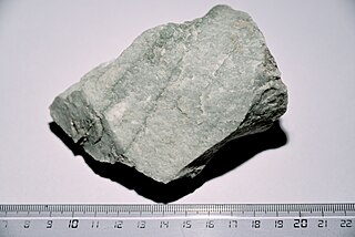
Quartzite is a hard, non-foliated metamorphic rock which was originally pure quartz sandstone. Sandstone is converted into quartzite through heating and pressure usually related to tectonic compression within orogenic belts. Pure quartzite is usually white to grey, though quartzites often occur in various shades of pink and red due to varying amounts of hematite. Other colors, such as yellow, green, blue and orange, are due to other minerals.
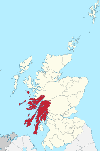
Argyll, sometimes called Argyllshire, is a historic county and registration county of western Scotland. The county ceased to be used for local government purposes in 1975 and most of the area now forms part of the larger Argyll and Bute council area.

Sand mining is the extraction of sand, mainly through an open pit but sometimes mined from beaches and inland dunes or dredged from ocean and river beds. Sand is often used in manufacturing, for example as an abrasive or in concrete. It is also used on icy and snowy roads usually mixed with salt, to lower the melting point temperature, on the road surface. Sand can replace eroded coastline. Some uses require higher purity than others; for example sand used in concrete must be free of seashell fragments.

Mining in Japan is minimal because Japan does not possess many on-shore mineral resources. Many of the on-shore minerals have already been mined to the point that it has become less expensive to import minerals. There are small deposits of coal, oil, iron and minerals in the Japanese archipelago. Japan is scarce in critical natural resources and has been heavily dependent on imported energy and raw materials. There are major deep sea mineral resources in the seabed of Japan. This is not mined yet due to technological obstacles for deep sea mining.
Morvern, historically also spelt Morven, is a peninsula and traditional district in the Highlands, on the west coast of Scotland. It lies south of the districts of Ardgour and Sunart, and is bounded on the north by Loch Sunart and Glen Tarbert, on the south east by Loch Linnhe and on the south west by the Sound of Mull. The highest point is the summit of the Corbett Creach Bheinn which reaches 853 metres (2,799 ft) in elevation.

Construction aggregate, or simply aggregate, is a broad category of coarse- to medium-grained particulate material used in construction, including sand, gravel, crushed stone, slag, recycled concrete and geosynthetic aggregates. Aggregates are the most mined materials in the world. Aggregates are a component of composite materials such as concrete and asphalt; the aggregate serves as reinforcement to add strength to the overall composite material. Due to the relatively high hydraulic conductivity value as compared to most soils, aggregates are widely used in drainage applications such as foundation and French drains, septic drain fields, retaining wall drains, and roadside edge drains. Aggregates are also used as base material under foundations, roads, and railroads. In other words, aggregates are used as a stable foundation or road/rail base with predictable, uniform properties, or as a low-cost extender that binds with more expensive cement or asphalt to form concrete. Although most kinds of aggregate require a form of binding agent, there are types of self-binding aggregate which require no form of binding agent.

Crushed stone or angular rock is a form of construction aggregate, typically produced by mining a suitable rock deposit and breaking the removed rock down to the desired size using crushers. It is distinct from naturally occurring gravel, which is produced by natural processes of weathering and erosion and typically has a more rounded shape.
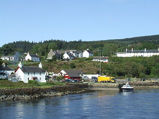
Lochaline is the main village in the Morvern area of Highland, Scotland. The coastal village is situated at the mouth of Loch Aline, on the northern shore of the Sound of Mull. A ferry operates regularly over to Fishnish on the Isle of Mull.

The Michigan Limestone and Chemical Company operated the world's largest limestone quarry, which is located near Rogers City in Presque Isle County, Michigan. It was formed and organized in 1910; however, production did not begin until 1912. Ownership of the quarry has changed a number of times, but it is still one of the largest producers of limestone in the United States. The quarry was inextricably interlinked with lake shipping and railroad transportation.

Sand is a granular material composed of finely divided mineral particles. Sand has various compositions but is defined by its grain size. Sand grains are smaller than gravel and coarser than silt. Sand can also refer to a textural class of soil or soil type; i.e., a soil containing more than 85 percent sand-sized particles by mass.

Ardtornish is a Highland estate in Scotland located in Morvern, Lochaber. Ardtornish House is famous for its gardens and the estate is the location of the ruined Ardtornish Castle and the still-inhabited Kinlochaline Castle.

Mining in the United Kingdom produces a wide variety of fossil fuels, metals, and industrial minerals due to its complex geology. In 2013, there were over 2,000 active mines, quarries, and offshore drilling sites on the continental land mass of the United Kingdom producing £34bn of minerals and employing 36,000 people.

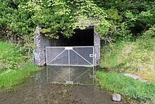
Glensanda was a Viking settlement at the mouth of Glen Sanda on the Morvern peninsula within south west Lochaber, overlooking the island of Lismore and Loch Linnhe in the western Highlands of Scotland.
This article describes the geology of the Brecon Beacons National Park in mid/south Wales. The area gained national park status in 1957 with the designated area of 1,344 km2 (519 sq mi) including mountain massifs to both the east and west of the Brecon Beacons proper. The geology of the national park consists of a thick succession of sedimentary rocks laid down from the late Ordovician through the Silurian and Devonian to the late Carboniferous period. The rock sequence most closely associated with the park is the Old Red Sandstone from which most of its mountains are formed. The older parts of the succession, in the northwest, were folded and faulted during the Caledonian orogeny. Further faulting and folding, particularly in the south of the park is associated with the Variscan orogeny.

The geology of the Isle of Mull in Scotland is dominated by the development during the early Palaeogene period of a ‘volcanic central complex’ associated with the opening of the Atlantic Ocean. The bedrock of the larger part of the island is formed by basalt lava flows ascribed to the Mull Lava Group erupted onto a succession of Mesozoic sedimentary rocks during the Palaeocene epoch. Precambrian and Palaeozoic rocks occur at the island's margins. A number of distinct deposits and features such as raised beaches were formed during the Quaternary period.
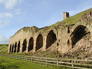
The Ironstone mining in Rosedale, was a major mining concern, in Rosedale, North Yorkshire, England. It flourished in the 19th century and ceased in the early 20th, though smaller scale iron workings were in use through the Middle Ages. The ironstone from Rosedale was typically rated at a higher iron ore concentration in the rock than other mines in the Cleveland and North Yorkshire area.

Winsford Mine is a halite mine in the town of Winsford, Cheshire, England. The mine produces an average of 1,500,000 tonnes of rock salt a year, which is used to grit public roads in the United Kingdom during the winter months. Two other mines also produce rock salt within the United Kingdom, but Winsford has the biggest output of all three and has the largest market share.