
Keston is a village in Greater London, England, located within the London Borough of Bromley, Greater London. Prior to 1965 it was within the historic county of Kent. It is part suburban, part rural in nature and lies on the edge of Hayes Common, just beyond the London conurbation to the south of Bromley Common. It includes the small hamlet of Nash to the southwest. The northern, more suburban part of Keston is sometimes referred to as Keston Mark.

Yate is a town and civil parish in South Gloucestershire, England. It lies just to the southwest of the Cotswold Hills and is 12 miles northeast of Bristol and 12 miles from Bath.

Kingswood is a town and civil parish in the South Gloucestershire district of the ceremonial county of Gloucestershire, England. The town is situated 3 miles (4.8 km) east-northeast of Bristol.
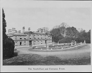
Aston Clinton House was a large mansion to the south-east of the village of Aston Clinton in Buckinghamshire, England.

The Taff Trail is a walking and cycle path that runs for 55 miles (89 km) between Cardiff Bay and Brecon in Wales. It is so named because it follows the course of the River Taff. Along much of its length, it follows the National Cycle Network Route 8 that continues to Holyhead, and is substantially off-road.
Fishponds is a large suburb in the north-east of the English city of Bristol, about 3 miles (5 km) from the city centre. It has two large Victorian-era parks: Eastville Park and Vassall's Park. The River Frome runs through both with the Frome Valley Walkway alongside it. A restored mill found at Snuff Mills near the Vassall's Park end of the river has kept its original waterwheel, which can still be seen and heard turning. Eastville Park has a large boating lake with central wildlife reserves. Fishponds is mainly residential. Two main bus routes pass through. Housing is typically terraced Victorian. The high street shops include an international supermarket, Asian food store, charity shops, takeaways and Lidl, Aldi and Morrisons supermarkets. It has a small student population from the presence of the Glenside campus of the University of the West of England. The name Fishponds derives from when it was a quarry district, like nearby Soundwell. The empty quarries became large fishponds, which have since been filled in. One remained until the mid-1970s, when it was officially closed: a popular swimming area named "The Lido" by locals. It now belongs to an angling club.

Warmley is a village in South Gloucestershire, England.

The A217 is a road in London and Surrey in England. It runs north–south. It runs from Kings Road in Fulham, London, crosses the Thames at Wandsworth Bridge, then passes through Wandsworth, Earlsfield, Summerstown, Tooting, Mitcham, Rosehill and Sutton Common in Sutton, then Cheam. Then, widened as a dual carriageway, comes Belmont, a suburban district built on a slope rising southward. On the North Downs in Surrey the road then skirts past Banstead and through its late 19th century offspring villages particularly Burgh Heath and Kingswood, Surrey. It then crosses the M25 motorway at Junction 8, then, returning to single carriageways, passes through the castle town of Reigate. It then cuts through the green buffer farmland of two rural villages and terminates at the road network at Gatwick Airport's northern perimeter.

Bristol Tramways operated in the city of Bristol, England from 1875, when the Bristol Tramways Company was formed by Sir George White, until 1941 when a Luftwaffe bomb destroyed the main power supply cables.
Bonaparte Provincial Park is an 11,811 hectare provincial park in British Columbia, Canada. It is located within the Bonaparte Plateau.
Charlton was the name of a small village or large hamlet in Gloucestershire, England with a Bethel Chapel and Sunday School. It was demolished in the late 1940s. Its site is occupied by part of the derelict runway and safety margins of the former Bristol Filton Airport. The village was located between Filton and what is today the Cribbs Causeway out-of-town commercial and retail area immediately north of Bristol. To the north of the village lay fields and Over Court Deer Park, which is today Bristol Golf Club.
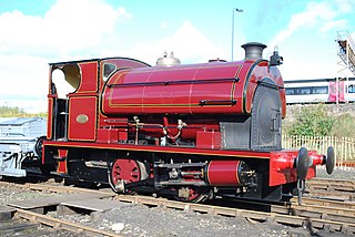
Peckett and Sons was a locomotive manufacturer at the Atlas Locomotive Works on Deep Pit Road between Fishponds and St. George, Bristol, England.

Snow Bunny is a small snow play area in Mount Hood National Forest on the south face of Mount Hood in Oregon, United States, about 65 miles (105 km) east of Portland. Inner tubing, tobogganing and other snow sports are on a maintained 20-foot (6.1 m) to 30-foot (9.1 m) hill of snow, popular with young children and families. It was established in 1952 as Mount Hood's first snow play area for children.

Hillfields is an area and ward of north-east Bristol.
Mayfield Park is a residential area in East Bristol, with a large adjoining park known as the Ridgeway Rd Playing Fields.
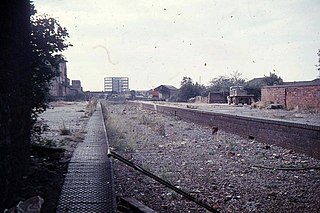
Fishponds railway station was a station in Fishponds, Bristol, England, which was closed by Dr Beeching's cuts in the 1960s.
Lodge Hill is a hill and residential area of Bristol, England. It is in the electoral ward of Hillfields, Bristol, separating the large outer urban areas of Fishponds and Kingswood. Cossham Memorial Hospital is at its peak which is the highest point in urban Bristol at 369 ft. It has a population of 1,722 (est).
Bradley is a small village in the Stroud District, in the county of Gloucestershire, England.

Stapleton Road is a major thoroughfare in the English city of Bristol, running through the districts of Lawrence Hill and Easton. It is known for being very culturally diverse with many esoteric shops. However since the mid 20th century it has gained a reputation for having a high crime rate.

Kingswood, occasionally referred to as Kingswood Parks, is a modern housing estate on the northern fringe of Kingston upon Hull, England.
