Related Research Articles
The Parliament of the Republic of Fiji is the unicameral legislature of the Republic of Fiji. It consists of 55 members elected every 4 years using open list proportional representation in one multi-member nationwide constituency.
Burebasaga is the largest of the three confederacies that make up Fiji's House of Chiefs, to which some of the Fijian chiefs belong.

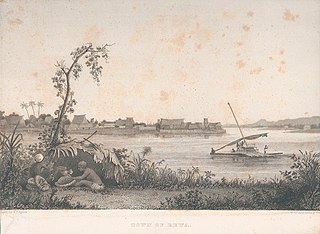
The Rewa River is the longest and widest river in Fiji. Located on the island of Viti Levu, the Rewa originates in Tomanivi, the highest peak in Fiji, and flows southeast for 145 km to Laucala Bay, near Suva. The Rewa River drains approximately one-third of Viti Levu.

The Central Division of Fiji is one of Fiji's four divisions. It consists of five provinces - Naitasiri, Namosi, Rewa, Serua and Tailevu.
Nabua is a suburb of the Fijian capital of Suva. The Queen Elizabeth Barracks, a major military base which saw a mutiny on 2 November 2000, is located there.
The Kadavu Group is an archipelago south of Viti Levu, one of Fiji's two main islands. Dominated by Kadavu Island, the fourth largest island in Fiji, the group also includes Ono, Dravuni, Galoa and a number of islets in the Great Astrolabe Reef.

Fulaga is a crescent-shaped reef-limestone island in Fiji's Southern Lau Group.
Vuaqava is an outlier to Kabara, 5 kilometers to the SSW, in Fiji's Southern Lau Group. It occupies an area of 8.1 km2. This limestone island has a maximum altitude of 107 meters. The island is uninhabited but visited by fishermen.
Tubou is a village on the Fijian island of Lakeba, with a population of about 2,000. One of eight villages on Lakeba, it is considered the capital of the Lau Islands, being the seat of the Vuanirewa clan, a powerful chiefly family from which Fiji's longtime Prime Minister and President, Ratu Sir Kamisese Mara (1920–2004) and one of Fiji's famous cricketers I. L. Bula, hailed.

Lami, is an urban area in Rewa Province, Fiji, north-west of the capital Suva. It was formally incorporated as a town in 1977, and had a population of 20,529 at the most recent census in 2007. The municipal boundaries enclose an area of 683 square kilometers.

Bua is one of fourteen provinces of Fiji. Located in the west of the northern island of Vanua Levu, it is one of three northern provinces, and has a land area of 1,379 square kilometers within the three main districts of Bua, Vuya and Wainunu. Its population at the 2017 census was 15,466, making it the fifth least-populous Province.
Rewa is a province of Fiji. With a land area of 272 square kilometers, it includes the capital city of Suva and is in two parts — one including part of Suva's hinterland to the west and a noncontiguous area to the east, separated from the rest of Rewa by Naitasiri Province. The province had a population of 108,016 at the 2017 census, making it Fiji's third most populous.
Serua is one of Fiji's fourteen provinces. Its 830 square kilometers occupy the southernmost areas of Viti Levu, being one of 8 provinces based on Fiji's largest island. It had a population of 15,461 at the 2007 census.
The Reserve Bank of Fiji is the central bank of the Pacific island country of Fiji. Its responsibilities include the issue of currency, control of the money supply, currency exchange, monetary stability, promotion of sound finances, and fostering economic development.
Vodafone Arena is an arena in Suva, Fiji. The arena was constructed for the 2003 South Pacific Games that was held in Suva. Today, it is primarily used for netball and was intended to host the 2007 Netball World Championships, before Fiji's hosting of the event was cancelled in the wake of the military coup of 5 December 2006. The arena holds 4,000 people. It was previously known as the FMF Dome.
The Fiji School of Medicine is a tertiary institution based in Suva, Fiji. Originally established in 1885 as the Suva Medical School. FSM became the College of Medicine, Nursing & Health Sciences as part of Fiji National University in 2010. It is located on the main island of Viti Levu in the Fiji Islands.

Lau Province is one of fourteen provinces of Fiji. Its capital is at Tubou, at the southern end of the island of Lakeba. The province forms part of the country's Eastern Division, and of the Tovata Confederacy, a traditional hierarchy of chiefs from northern and eastern Fiji.
Lomaiviti Province is one of the 14 provinces of Fiji. Administratively, it forms part of Fiji's Eastern Division and of the Kubuna Confederacy, one of three traditional chiefly hierarchies in Fiji.
The Ministry of Foreign Affairs & International Cooperation is the ministry responsible for handling the Republic of Fiji's external relations. The ministry's current director is the Minister of Foreign Affairs and International Cooperation, Sitiveni Rabuka, who took the position in December 2022.
References
- ↑ "Lomanikoro" . Retrieved 30 April 2017.
18°6′16″S178°33′29″E / 18.10444°S 178.55806°E
| | This article about a geographical location in Fiji is a stub. You can help Wikipedia by expanding it. |