
Blackfriars Bridge is a road and foot traffic bridge over the River Thames in London, between Waterloo Bridge and Blackfriars Railway Bridge, carrying the A201 road. The north end is in the City of London near the Inns of Court and Temple Church, along with Blackfriars station. The south end is in the London Borough of Southwark, near the Tate Modern art gallery and the Oxo Tower. Opened in the 1860s, it replaced an earlier bridge from the 1760s.

The Bakerloo line is a London Underground line that runs between Harrow & Wealdstone in suburban north-west London and Elephant & Castle in south London, via the West End. Printed in brown on the Tube map, it serves 25 stations, 15 of which are underground, over 23.2 kilometres (14.4 mi). It runs partly on the surface and partly through deep-level tube tunnels.

The London Borough of Southwark in South London forms part of Inner London and is connected by bridges across the River Thames to the City of London and the London Borough of Tower Hamlets. It was created in 1965 when three smaller council areas were amalgamated under the London Government Act 1963. All districts of the area are within the London postal district. It is governed by Southwark London Borough Council.

Elephant and Castle is an area of South London, England, in the London Borough of Southwark. The name also informally refers to much of Walworth and Newington, due to the proximity of the London Underground station of the same name. The name is derived from a local coaching inn.

New Kent Road is a 1 kilometre (0.6 mi) road in the London Borough of Southwark. The road was created in 1751 when the Turnpike Trust upgraded a local footpath. This was done as part of the general road improvements associated with the creation of Westminster Bridge; in effect it was possible to travel from the West End/ Westminster to the south-east without having to go via the Borough of Southwark but could now cross St George's Fields to the junction of Newington Causeway and Newington Butts which is where New Kent Road starts at Elephant & Castle. The route runs eastward for a few hundred yards to the junction of Great Dover Street and Tower Bridge Road, known as Bricklayers Arms, where it joins the original route to the south-east Old Kent Road.

Blackfriars, also known as London Blackfriars, is a central London railway station and connected London Underground station in the City of London. It provides Thameslink services: local, and regional and limited Southeastern commuter services to South East London and Kent. Its platforms span the River Thames, the only station in London to do so, along the length of Blackfriars Railway Bridge, a short distance downstream from Blackfriars Bridge. There are two station entrances – one on each side of the Thames – along with a connection to the London Underground District and Circle lines.

London South Bank University (LSBU) is a public university in Elephant and Castle, London. It is based in the London Borough of Southwark, near the South Bank of the River Thames, from which it takes its name. Founded in 1892 as the Borough Polytechnic Institute, it achieved university status in 1992 under the Further and Higher Education Act 1992.

Borough High Street is a road in Southwark, London, running south-west from London Bridge, forming part of the A3 route which runs from London to Portsmouth, on the south coast of England.

Skipton House is a high specification office building in Elephant and Castle, Central London.

Borough Road is in Southwark, London SE1. It runs east–west between St George's Circus and Borough High Street.
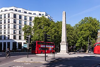
St George's Circus is a road junction in Southwark, London, England. At its centre, which is now a traffic roundabout, is an historic obelisk, designed by Robert Mylne (1733–1811), in his role as surveyor and architect of Blackfriars Bridge.

Westminster Bridge Road is a road in London, England. It runs on an east–west axis and passes through the boroughs of Lambeth and Southwark.

Blackfriars Road is a road in Southwark, SE1. It runs between St George's Circus at the southern end and Blackfriars Bridge over the River Thames at the northern end, leading to the City of London. Halfway up on the west side is Southwark Underground station, on the corner with The Cut. Opposite is Palestra, a large office building which houses the Surface transport division of Transport for London, which was formerly the headquarters of the London Development Agency.

Southwark Bridge Road is a road in Southwark, London, England, between Newington Causeway near Elephant and Castle and Southwark Bridge across the River Thames, leading to the City of London, in a meandering route.
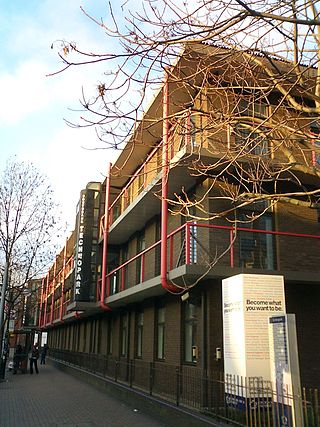
South Bank Technopark at London South Bank University, England, houses the main administration for the university, including the Vice-Chancellor's Office, under the leadership of Prof. David Phoenix.

Grosvenor Road station was a railway station in London located at the north end of Grosvenor Bridge on the approach tracks to Victoria station. Victoria station was originally operated as two separate parts served by the London, Chatham and Dover Railway (LC&DR) and the London, Brighton and South Coast Railway (LB&SCR) and Grosvenor Road station was also operated in this way. The LC&DR station operated between 1867 and 1911 and the LB&SCR station operated between 1870 and 1907. The station building of the LC&DR station remains on the eastern side of the tracks adjacent to Grosvenor Road (A3212) although no platforms remain at the elevated track level.

The A201 is an A road in London, England running from Kings Cross to Bricklayer's Arms.

Elephant & Castle railway station is a National Rail station in Newington, south London. Along with the London Underground station of the same name, it is located in the London Borough of Southwark and is in both Travelcard Zone 1 and 2. The station is managed by Thameslink, with services operated by both Thameslink and Southeastern. There is out-of-station interchange with the nearby Elephant & Castle tube station.

Walworth Road railway station was a railway station in Walworth Road, Southwark, south London, England, on the London Chatham & Dover Railway, which opened on 1 May 1863 on the City Branch to Blackfriars as part of the company's ambitious plan to extend into the City of London. It was originally known as Camberwell Gate before changing its name in 1865.

Camberwell is a closed railway station in Camberwell, South London, England. It opened in 1862 but was closed to passengers in 1916 and closed to all traffic in 1964. The possibility of the station's re-opening has been raised in recent years.


