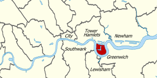
The Isle of Dogs is a large peninsula. It is bounded on three sides by a large meander in the River Thames in East London, England, which includes the Cubitt Town, Millwall and Canary Wharf districts. The area was historically part of the Manor, Hamlet, Parish and, for a time, the wider borough of Poplar. The name had no official status until the 1987 creation of the Isle of Dogs Neighbourhood by Tower Hamlets London Borough Council. It has been known locally as simply "the Island" since the 19th century.
The Port of London is that part of the River Thames in England lying between Teddington Lock and the defined boundary with the North Sea and including any associated docks. Once the largest port in the world, it was the United Kingdom's largest port as of 2020. Usage is largely governed by the Port of London Authority ("PLA"), a public trust established in 1908; while mainly responsible for coordination and enforcement of activities it also has some minor operations of its own.

Blackwall is an area of Poplar, in the London Borough of Tower Hamlets, East London. The neighbourhood includes Leamouth and the Coldharbour conservation area.

Millwall is a district on the western and southern side of the Isle of Dogs, in east London, England, in the London Borough of Tower Hamlets. It lies to the immediate south of Canary Wharf and Limehouse, north of Greenwich and Deptford, east of Rotherhithe, west of Cubitt Town, and has a long shoreline along London's Tideway, part of the River Thames. It was part of the County of Middlesex and from 1889 the County of London following the passing of the Local Government Act 1888, it later became part of Greater London in 1965.

Cubitt Town is a district on the eastern side of the Isle of Dogs in London, England. This part of the former Metropolitan Borough of Poplar was redeveloped as part of the Port of London in the 1840s and 1850s by William Cubitt, Lord Mayor of London (1860–1862), after whom it is named. It is on the east of the Isle, facing the Royal Borough of Greenwich across the River Thames. To the west is Millwall, to the east and south is Greenwich, to the northwest Canary Wharf, and to the north — across the Blue Bridge — is Blackwall. The district is situated within the Blackwall & Cubitt Town Ward of Tower Hamlets London Borough Council.

Leamouth is a locality in the Blackwall area of Poplar, in the London Borough of Tower Hamlets. The area takes its name from the former Leamouth Wharf and lies on the west side of the confluence of the Bow Creek stretch of the Lea, at its confluence with the River Thames.

Orchard House Yard was an English shipbuilding yard located at Leamouth, on the River Lea at Bow Creek. Forming part of the Orchard House estate, a number of shipbuilders occupied the site over time:

The Thames Ironworks and Shipbuilding Company, Limited was a shipyard and iron works straddling the mouth of Bow Creek at its confluence with the River Thames, at Leamouth Wharf on the west side and at Canning Town on the east side. Its main activity was shipbuilding, but it also diversified into civil engineering, marine engines, cranes, electrical engineering and motor cars.
Yarrow Shipbuilders Limited (YSL), often styled as simply Yarrows, was a major shipbuilding firm based in the Scotstoun district of Glasgow on the River Clyde. It is now part of BAE Systems Surface Ships, owned by BAE Systems, which has also operated the nearby Govan shipyard since 1999.

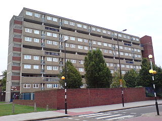
The Samuda Estate is on the east side of Manchester Road, in Cubitt Town on the Isle of Dogs. With 505 dwellings it is home to about 1,500 people and covers 11.4 acres (4.6 ha).

Samuda Brothers was an engineering and ship building firm at Cubitt Town on the Isle of Dogs in London, founded by Jacob and Joseph d'Aguilar Samuda. The site is now occupied by Samuda Estate.
Blackwall Yard is a small body of water that used to be a shipyard on the River Thames in Blackwall, engaged in ship building and later ship repairs for over 350 years. The yard closed in 1987.
St John's Estate is a housing scheme in Cubitt Town, on the Isle of Dogs in London. Centred on the triangle formed by Manchester Road, East Ferry Road and Glengall Grove, it was developed by Poplar Borough Council after the Second World War. It is served by Crossharbour DLR station to which it is adjacent.
The A1206, also known as the Isle of Dogs Distributor Road, is a crescent-shaped ring road around the Isle of Dogs, in the East End of London. It is made up of Westferry Road, Manchester Road and Prestons Road and is the main road through the area, connecting parts of the London Docklands.
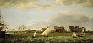
The Millwall Iron Works, London, England, was a 19th-century industrial complex and series of companies, which developed from 1824. Formed from a series of small shipbuilding companies to address the need to build larger and larger ships, the holding company collapsed after the Panic of 1866 which greatly reduced shipbuilding in London. Subsequently, a recovery was made by a series of smaller companies, but by the later 19th century the location was too small for the building of ships on the scale then required. Most of its buildings, being near the apex of the peninsula in the Isle of Dogs, survived the Blitz and have been made into apartment blocks in a residential estate, Burrells Wharf.
Westwood, Baillie and Co was a Victorian engineering and shipbuilding company based at London Yard in Cubitt Town, London.

J & W Dudgeon was a Victorian shipbuilding and engineering company based in Cubitt Town, London, founded by John and William Dudgeon.

Coldharbour is a street and wider conservation area in Blackwall, lying on the north bank of the River Thames, east of Canary Wharf. The area is said to be "[t]he sole remaining fragment of the old hamlet of Blackwall" and "one of the last examples of the narrow streets which once characterised the river's perimeter".
Glengall Road was a football ground on the Isle of Dogs in East London. It was the first home of Millwall – then known as Millwall Rovers – from its foundation in 1885 until 1886, when the club moved to the Lord Nelson Ground in the south of the Island. It is the only ground they played in throughout their history within the district of Millwall.
