
Lampasas County is a county located on the Edwards Plateau in the U.S. state of Texas. As of the 2020 census, its population was 21,627. Its county seat is Lampasas. The county is named for the Lampasas River.

A California Historical Landmark (CHL) is a building, structure, site, or place in the U.S. state of California that has been determined to have statewide historical landmark significance.

Samuel P. Taylor State Park is a state park located in Marin County, California, United States, which includes approximately 2,700 acres (11 km2) of redwood forest and grassland. The park contains about 600 acres (2.4 km2) of old-growth forest, some of which can be seen along the Pioneer Tree Trail.

The Kern River Oil Field is a large oil field in Kern County in the San Joaquin Valley of California, north-northeast of Bakersfield in the lower Sierra foothills. Yielding a cumulative production of close to 2 billion barrels (320,000,000 m3) of oil by the end of 2006, it is the third largest oil field in California, after the Midway-Sunset Oil Field and the Wilmington Oil Field, and the fifth largest in the United States. Its estimated remaining reserves, as of the end of 2006, were around 476 million barrels (75,700,000 m3), the second largest in the state. It had 9,183 active wells, the second highest in the state. The principal operator on the field is Chevron Corporation
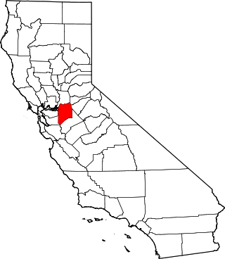
This is a list of the National Register of Historic Places listings in San Joaquin County, California.

The Sebastian Indian Reservation (1853-1864), more commonly known as the Tejon Indian Reservation, was formerly at the southwestern corner of the San Joaquin Valley in the Tehachapi Mountains, in southern central California.
Clements is an unincorporated community in San Joaquin County, California, United States. Clements is located on California State Route 12 and California State Route 88, 11 miles (18 km) east-northeast of Lodi. Clements has a post office with ZIP code 95227.
The Miners Foundry is located at 325 Spring Street, Nevada City, California, USA. Built in Nevada County in 1856, it is a California Historical Landmark as, in 1879, the foundry became the first manufacturing site of the Pelton wheel.

San Joaquin City is a former settlement in San Joaquin County, California. It was established in 1849, during the California Gold Rush. It was located on the west bank of the San Joaquin River just below the point where Airport Way crosses the river today. It was an important settlement along the old River Road between Banta and Grayson's Ferry (now the community of Grayson in Stanislaus County.

Sheldon Grist Mill Site, is historical site in Sloughhouse, California in Sacramento County. The site is a California Historical Landmark No. 604 listed on June 2, 1949. The water powered gristmill, was used turn grain into flour, was on Rancho Omochumnes. The gristmill was built by Jared Dixon (Joaquin) Sheldon. Sheldon was grant then five square league of land on Rancho Omochumnes by the First Mexican Republic in 1843 by Mexican Governor Manuel Micheltorena as payment for carpenter work on the Monterey Custom House. Sheldon born on January 8, 1813, in Vermont and travelled to California 1832, working as a carpenter and millwright. Sheldon married Catherine Rhoads, the daughters of Thomas Rhoads in March 1847. Sheldon and his partner, William Daylor, also did some gold mining. Sheldon built a dam on Clark's Bar river on the his Sheldon Grant to irrigate the crops on his lands. The dam flood a California Gold Rush miners' claims. The angry miners' shot Sheldon on July 11, 1851. The conflict with Sheldon and the miners is called the Riot on the Cosumnes. In the conflict Sheldon was not the only one shot. Also Killed was James M. Johnson of Lancaster, Iowa and Edward Cody of Fox River, Illinois. Three were wounded: Calvin Dickerson of Berrien County, Michigan, Emanuel Bush of Des Moines County, Iowa and one unnamed miner. The Sheldon Grant was boarded on the south by the Cosumnes River and north by Deer Creek, 17 miles long between the rivers. The Sheldon Grist Mill was just west of the Sloughhouse Pioneer Cemetery, where Sheldon and his partner William Daylor and are buried. The site today is still mostly farmland.

Casa de Carrillo House in San Diego, California in San Diego County, is a California Historical Landmark No. 74 listed on December 6, 1932. The Casa de Carrillo House is the oldest residence in San Diego. The Casa de Carrillo House was built by Presidio of San Diego Comandante Francisco María Ruiz (1754–1839). Ruiz was the leader of the Presidio from 1809 to 1827. The Casa de Carrillo house was built next to his pear orchard planted in 1808. The Adobe house was used by his relative and soldier, Joaquín Carrillo, and his family. Joaquín Carrillo, daughter Josefa Carrillo, ran away and sailed from the home and eloped to Chile with Henry Delano Fitch in April 1829. Francisco Ruiz died in 1839, when Joaquín Carrillo died, his son Ramon Carrillo sold the house and land to Lorenzo Soto. The house and land was sold a few times, it was poor condiction when sold in 1932 to George Marston and associates. George Marston and associates restored the house. After the restoration George Marston and associates donated the house and land to the City of San Diego. The City of San Diego turned the house and land into the Presidio Hills Golf Course.
Battle of Stanislaus site is a historical site in Manteca, California in San Joaquin County. The Battle of Stanislaus site is a California Historical Landmark No. 214 listed on June 20, 1935. The Battle of Stanislaus was fought in 1829 on the North bank of the Stanislaus River, near the meeting of the San Joaquin River and Stanislaus River. The Governor of California, José María de Echeandía, ordered Mariano Guadalupe Vallejo to attacked the Cosumnes tribe, a Miwok, Yokuts and Nisenan people group. Cosumnes has earlier raided local ranches in the area. The fight was one of a number of battles fought at the time in the San Joaquin Valley. The war between the tribes and First Mexican Republic in Alta California did not end due to a war end, but by a mosquito-borne disease, malaria. Malaria can into the San Joaquin Valley in 1833 by Canadian beaver trappers with the Hudson's Bay Company. Over 20,000 California natives died from malaria in 1833. The Battle of Stanislaus was the last of the California Northern tribal wars. The war The Mexican army used cannons to fight the last of these wars.

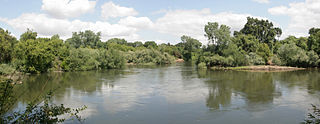
California Chicory Works site is a historical site in Stockton, California in San Joaquin County. California Chicory Works site is a California Historical Landmark No. 935, listed on September 30, 1980. In 1885, C. A. Bachmann and Charles H. W. Brandt formed a partnership and built the largest chicory plant in America by the 1890s. At the California Chicory Works, chicory roots were roasted and grounded on the finest German machinery and mills. The chicory root was often mixed with coffee or used alone for a tea hot drink. At its peak California Chicory Works purchase a cargo ship the Dora to ship its product to the east coast and other ports. The mill was on and powered by the San Joaquin River. The market dropped in about 1911 and the plant closed shortly after.

Lindsay Point was the First Building in Stockton the site is a historical place in Stockton, California in San Joaquin County. Lindsay Point site is a California Historical Landmark No. 178, listed on March 6, 1935. The first settlers arrived at Rancho Campo de los Franceses in August 1844. One of the early settlers was Thomas Lindsay. Lindsay copied the natives and built a tule reed hut. Lindsay was later killed by natives and buried by other settlers. The Lindsay Point is the meeting site of McLeod Lake and the Miner's Channel. Miner's Channel ran between Miner Street and Channel Street. Miner Street sometimes flood, so it was piped and filled in. In 2000 archaeologists did an excavation of the past site of Miner Channel and uncovered artifacts from 1890s to the 1930s. The excavation was done before the new Cineplex complex was built.
New Hope Agricultural Colony is a historical site in Ripon, California in San Joaquin County. New Hope Agricultural Colony site is a California Historical Landmark No. 436, listed on June 2. 1942. In 1846, the first wheat in the San Joaquin Valley was planted about six miles west of Ripon by 20 Mormon pioneers that arrived from Brooklyn by ship. The crop was irrigated by the pole and bucket lifting method. The pioneers built three log homes, a sawmill and cable ferry across Stanislaus River, that became later Stanislaus City. On June 27, 1844, Mormons leader Joseph Smith was killed, follower of Joseph Smith moved west, most came west by wagon trains. The group at Ripon came by ship to San Francisco.
Temple Israel Cemetery is a historical site in Stockton, California in San Joaquin County. Stockton Developmental Center is a California Historical Landmark No. 765, listed on August 10, 1961. The land for Temple Israel Cemetery was donated by Captain Charles M. Weber in 1851. The local Jewish community of Stockton Temple Israel of Stockton built a cemetery on the land. Temple Israel Cemetery is the oldest Jewish cemetery in continuous use in California, also west of the Rocky Mountains.

Weber Point Home is a historical site in Stockton, California in San Joaquin County. The site of the former Weber Point Home is a California Historical Landmark No. 165, listed on January 11, 1935. The Weber Point Home was a built by Captain Charles M. Weber founder of Stockton. Weber was pioneer of California and built a two-story adobe-and-redwood house in 1850. At the time it was the largest house in Stockton. The house was built on the east end of the Stockton Channel. The house was surrounded by landscaped gardens built for his new wife Helen Murphy. Weber lived in the house till his death in 1881. The house was located on Center Street between Channel and Miner Street in Stockton. The Weber Point House was destroyed in a fire in 1917. The Weber Point House was the center of the 8,747 acre Mexican land grant Rancho Campo de los Franceses. The Rancho owned present day Stockton and lands south and east, most of the current San Joaquin County.

Mission Hospice, also called, is a historical site in San Mateo, California in San Joaquin County on the San Mateo Creek. Mission Dolores Outpost site is a California Historical Landmark No. 393 listed on March 8, 1948. Mission Dolores Outpost was built by Spanish Padres with New Spain in 1786. The outpost was a resting spot on the El Camino Real trail running north to south to the Spanish missions in California. Mission Dolores Outpost was the stop between Mission Santa Clara de Asís and Mission San Francisco de Asís. The Mission Dolores outpost also worked with the local Natives. To feed the mission and natives of Mission Dolores had a farm outpost at an Ohlone Village. The outpost also raised cattle. Food was also taken to Mission San Francisco de Asís. The two main adobe buildings at the site were the large granary building and small chapel. Mission Dolores Outpost was abanded in about 1793 after diseases killed most of the native population. After the Mexican secularization act of 1833 the large granary building was used as an inn on the El Camino road. The mission land became Rancho San Mateo and Rancho de las Pulgas. In 1849 the output buildings also became a stagecoach stop, opened by Nicolas de Peyster. None of the Mission Hospice buildings now exist, the site is the center of city of San Mateo.

Steele Brothers Dairy Ranches is a historical site in Pescadero, California in San Joaquin County. Steele Brothers Dairy Ranches site is a California Historical Landmark No. 906 listed on February 8, 1977. The Steele Brothers: Edgar W. Steele, Isaac C. Steele, and Rensselaer E. Steele, were the pioneers of larger scale Dairy farming. Steele Brothers from Delaware, had large-scale commercial cheese and dairy plants. Steele Brothers operated 7,000-acre ranch with five dairies. The ranch ran from Gazos Creek on the north to Point Año Nuevo on the south, about 5 miles on the along the Coastal California, between the Pacific Ocean and Big Basin Redwoods. The five dairies were has far north as Point Reyes and as south as the one at Gazos Creek near Rancho Punta del Año Nuevo. The Steele Brothers operated from 1850 to 1950.
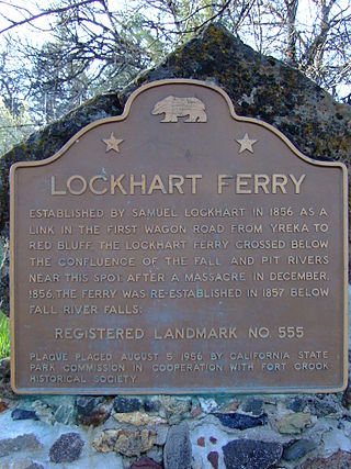
Lockhart Ferry foundation is a historical site in Fall River Mills, California in Shasta County. Lockhart Ferry site is a California Historical Landmark No. 555 listed on July 31, 1956. In 1856 Samuel Lockhart built a road and ferry, it was the first wagon trail road from the City of Yreka to the City of Red Bluff. To cross the Fall River Lockhart built a cable ferry across the river, just about the Pit River. Due to a native tribes attacks in the eara in December 1856, the ferry was moved down stream below Fall River Falls in 1857.


