Related Research Articles
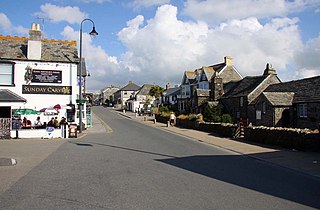
Tintagel or Trevena is a civil parish and village situated on the Atlantic coast of Cornwall, England, United Kingdom. The village and nearby Tintagel Castle are associated with the legends surrounding King Arthur and in recent times have become a tourist attraction. It was claimed by Geoffrey of Monmouth that the castle was an ancient residence of King Arthur.

Tintagel Castle is a medieval fortification located on the peninsula of Tintagel Island adjacent to the village of Tintagel (Trevena), North Cornwall in the United Kingdom. The site was possibly occupied in the Romano-British period, as an array of artefacts dating from this period have been found on the peninsula, but as yet no Roman-era structure has been proven to have existed there. It was settled during the early medieval period, when it was probably one of the seasonal residences of the regional king of Dumnonia. A castle was built on the site by Richard, 1st Earl of Cornwall in the 13th century, during the High Middle Ages. It later fell into disrepair and ruin.

North Cornwall is an area of Cornwall, England, United Kingdom. It is also the name of a former local government district, which was administered from Bodmin and Wadebridge 50.516°N 4.835°W. Other towns in the area are Launceston, Bude, Padstow, and Camelford.

Bossiney is a village in north Cornwall, England, United Kingdom. It is north-east of the larger village of Tintagel which it adjoins: further north-east are the Rocky Valley and Trethevy. Until 1832 the village, with its neighbour Tintagel, returned two MPs as a Rotten Borough, for the Bossiney constituency. The beach of Bossiney Haven is located nearby.

Treknow is a small village in Tintagel civil parish, Cornwall, England, United Kingdom: it is the second largest settlement, and is located between Trevena and Trebarwith. It is situated 19 miles (31 km) north of Bodmin, 4 miles (6.4 km) north-west of Camelford, and 1 mile (1.6 km) west of Tintagel, grid reference SX056869
Trebarwith Strand is a section of coastline located near the coastal settlement of Trebarwith on the north coast of Cornwall, England, UK, 2+1⁄2 miles (4.0 km) south of Tintagel. It has 800m of sandy beach contained by cliffs in which natural caves are found. The beach can only be accessed at low tide. The strand was once used to land ships to export slate from the nearby quarries while sand from the beach was used for agricultural purposes. The view from the beach is dominated by rocks 300m offshore known as Gull Rock or Otterham Rocks.

The geology of Cornwall, England, is dominated by its granite backbone, part of the Cornubian batholith, formed during the Variscan orogeny. Around this is an extensive metamorphic aureole formed in the mainly Devonian slates that make up most of the rest of the county. There is an area of sandstone and shale of Carboniferous age in the north east, and the Lizard peninsula is formed of a rare section of uplifted oceanic crust.
Gillow State Quarry is a small, disused slate quarry between Tintagel and Trebarwith on the north coast of Cornwall, South West England. The quarry was abandoned by the turn of the 20th century.

Lambshouse and Gull Point Quarries are two disused slate quarries between Tintagel and Trebarwith at Lambshouse Cove on the north coast of Cornwall, South West England. The quarries were latterly worked jointly as one site and were abandoned by the turn of the 20th century. It is likely that Lambshouse Quarry originated at the cliffs at the north of the cove while Gull Point was to the south.
Bagalow Quarry is a disused slate quarry between Tintagel and Trebarwith at Bagalow Cove on the north coast of Cornwall, South West England. The quarry was worked from the 1830s into the early part of the twentieth century.
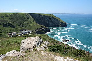
Tintagel Slate Quarries fall into two categories: the series of quarries lying between Tintagel Castle and Trebarwith Strand on the north coast of Cornwall, South West England and the open cast quarries further inland. There are around eight cliff-edge quarries as well as two wharfs, all of which are now disused as well as four inland sites, two of which are still in operation. The first quarry to be worked appears to have been Lanterdan at some point in the fifteenth century, while the last of the coastal quarries, Long Grass ceased operations in 1937. The remains of the coastal quarries occupy coastal land owned by the National Trust and most are easily accessible from the South West Coast Path. The Prince of Wales Quarry has been turned into a country park by North Cornwall District Council.

Hole Beach is a bathing and surf beach just north of Trebarwith Strand on the North Coast of Cornwall, South West England. The beach can be accessed from Trebarwith at low tide or by a zigzagging quarryman's track from the village of Treknow. The beach is sandy and the water is good for surfing. The sheer cliffs to the north of the beach form part of the now disused Caroline Slate Quarry and were created by quarrymen suspended by ropes attached to strongpoints some 75m on the clifftop above. A cave 15m above sea level is artificial and is also the result of quarrying- this is the "hole" that gives the beach its name. There is also a natural sea cave at the rear of the beach. One of the stone strong points still perches on top of the near vertical cliffs 75m above the beach, as does a second building which was possibly used as a toolshed.

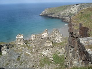
Lanterdan Quarry is a disused open cast slate quarry between Tintagel and Trebarwith on the north coast of Cornwall, South West England. The quarry is the oldest, largest and most spectacular of Tintagel’s coastal quarries and was worked from the fifteenth until the early twentieth century. A distinguishing feature of the quarry is a 25m high pinnacle of inferior slate.

Tintagel Haven also known as Castle Cove is a small beach on the north side of Tintagel Island on the north coast of Cornwall, South West England.
Penhallick Wharf is a disused coastal loading dock between Tintagel Castle and Trebarwith Strand on the north coast of Cornwall in South West England. The wharf served the Tintagel Slate Quarries, particularly those without easy access to the loading beach at Tintagel Haven. These include Caroline, Dria, Bagalow and possibly Lambshouse and Gull Point quarries.
West Quarry is a disused open cast slate quarry between Tintagel and Trebarwith on the north coast of Cornwall, South West England. The quarry ceased operations towards the end of the nineteenth century.

Lye Cove is a small coastal inlet near Tintagel on the north coast of Cornwall, South West England. The cove lies immediately below the Iron Age hill fort known as Willapark and nearby Lye Rock was the site of the wreck of the Italian cargo ship Iota in 1893. Above the cove is the remains of a nineteenth century lime kiln.

50.574°N 4.743°W
Iota was a wooden barque built in Bideford in 1866 and weighing 572 tons. The ship was owned by an Italian firm named Mazella based in Naples and was wrecked near Tintagel, Cornwall, on 20 December 1893.

Boscastle Slate Quarries are a series of disused coastal quarries between Willapark and Trevalga on the north coast of Cornwall, South West England.
References
- ↑ Dyer, Peter (2005) Tintagel: a portrait of a parish. Cambridge: Cambridge Books. ISBN 0-9550097-0-7; p. 200
- 1 2 Booklet: ”The National Trust Coast of Cornwall: 4 Tintagel”, Brian Le Messurier, 1991
- 1 2 «Coastal Slate Quarries – Tintagel to Trebarwith” (1990) Adam Sharpe, CAU archaeological survey for the National Trust. ISBN 1 871162 95 5
- ↑ Evidence report: the building stones of Cornwall; the identification of heritage quarries; Cornwall Council; p. 162
- ↑ "Geocaching - the Official Global GPS Cache Hunt Site". www.geocaching.com. Retrieved 27 April 2022.
- ↑ "Ship wreck victim remembered". www.thepost.uk.com. Retrieved 27 April 2022.[ title missing ]
- ↑ Dyer, Peter (2005) Tintagel: a portrait of a parish. Cambridge: Cambridge Books. ISBN 0-9550097-0-7; pp. 434-36