Long Island (Hermitage Bay, Newfoundland)

Last updated

Long Island
Canada Newfoundland location map.svg
Red pog.svg
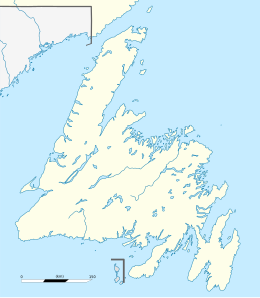
Long Island
Location of Long Island (Hermitage Bay, Newfoundland) in Newfoundland
Geography
Location Atlantic Ocean
Coordinates 47°38′45″N55°58′54″W / 47.64583°N 55.98167°W / 47.64583; -55.98167 Coordinates: 47°38′45″N55°58′54″W / 47.64583°N 55.98167°W / 47.64583; -55.98167
Administration
Province Newfoundland and Labrador
Largest settlement Gaultois

Long Island is a large, triangular-shaped island on the north side of Hermitage Bay, Newfoundland and Labrador, Canada. [1]

Presently, only one inhabited settlement remains on the island, though several abandoned and resettled communities can be found along its coast, including Piccaire and Little Bay. The town of Gaultois is located in a small cove near the eastern extreme of the island, and can be reached by passenger ferry several times daily. [2]

Related Research Articles

<span class="mw-page-title-main">Labrador</span> Mainland portion of Newfoundland and Labrador

Labrador is a geographic and cultural region within the Canadian province of Newfoundland and Labrador. It is the primarily continental portion of the province and constitutes 71% of the province's area but is home to only 6% of its population. It is separated from the island of Newfoundland by the Strait of Belle Isle. It is the largest and northernmost geographical region in the four Atlantic provinces.

The Strait of Belle Isle is a waterway in eastern Canada that separates the Labrador Peninsula from the island of Newfoundland, in the province of Newfoundland and Labrador.

<span class="mw-page-title-main">Fortune Bay-Cape La Hune</span> Provincial electoral district in Newfoundland and Labrador, Canada

Fortune Bay—Cape La Hune is a provincial electoral district for the House of Assembly of Newfoundland and Labrador, Canada. When created in 1975 it was called Fortune-Hermitage. As of 2011, there are 6,053 eligible voters living within the district.

Ramea is a small village in Newfoundland and Labrador located on Northwest Island, one of a group of five major islands located off the south coast of Newfoundland, Canada. The island is approximately 3.14 km long by 0.93 km wide. The other major islands in the archipelago are Great Island, Middle Island, Harbour Island, and South West Island.

The Burin Peninsula is a peninsula located on the south coast of the island of Newfoundland in the province of Newfoundland and Labrador. Marystown is the largest population centre on the peninsula.

<span class="mw-page-title-main">McCallum, Newfoundland and Labrador</span> Local service district / designated place in Newfoundland and Labrador, Canada

McCallum is a local service district and designated place in the Canadian province of Newfoundland and Labrador. It is on the southern coast of the island of Newfoundland. It is accessible only by boat or by air, and in appearance and way of life is thought by some to be as close to a pre-20th century community as may be found. McCallum lies in an enclosed harbour and is sheltered between two hills. The community survives primarily on the fishery. Whaling was also a major industry in the late 19th century. It is also about an hour and a half from the nearest road, in a community called Hermitage.

<span class="mw-page-title-main">Blanc-Sablon, Quebec</span> Municipality in Quebec, Canada

Blanc-Sablon is the easternmost community in Le Golfe-du-Saint-Laurent Regional County Municipality, in the administrative région of Côte-Nord, in the province of Quebec, Canada. With a population of 1,122 inhabitants in 2021, it is the most populous community in the county municipality.

Facheux Bay was the location of a small fishing settlement of the same name. In 1901 it had a population of 47. The community was also called Fachier, Facheaux, and Fouche. Facheux Bay is a deep fjord that separates Eastern Head and Western Head of Hermitage Bay, Newfoundland, Canada. Facheux bay is 2.25 miles (3.62 km) west of Mosquito Cove. The entrance is between two steep falls in high hills. The bay runs in 6.5 miles (10.5 km), with an average width of 0.75 miles (1.21 km), and has deep water throughout. On the west side are three coves with anchorage in 20 to 10 fathoms.

<span class="mw-page-title-main">Gaultois</span> Town in Newfoundland and Labrador, Canada

Gaultois is a small settlement in the Coast of Bays area in Newfoundland and Labrador, Canada. Gaultois had a population of 100 people as of 2021. The town has a K-12 school called Victoria Academy, as well as a fire department, public library, Lion's Club, and town hall. The town is only accessible by ferry or helicopter. The ferry runs from the nearby town of Hermitage several times daily and the crossing takes approximately 20 minutes. This ferry also services the more remote community of McCallum once to twice daily with a crossing time of around one hour and fifteen minutes. In 2015, Gaultois voted against resettlement.

<span class="mw-page-title-main">Rose Blanche-Harbour le Cou</span> Town in Newfoundland and Labrador, Canada

Rose Blanche – Harbour le Cou is a small town on Newfoundland's southwest shore, about 45 km at the end of Route 470 from Port aux Basques. This community is located in a barren area on the east side of a small bay. In this bay there are 2 harbours that were mainly used to provide shelter for fishing vessels. Scenery includes the rugged granite coastline, and the white and rocky cliffs of "Diamond Cove". Its granite lighthouse was in operation from 1873 to the 1940s. After it was abandoned in the 1940s the building fell into ruins. The spiral stone staircase extends into the tower wall and kept the tower from collapsing while the remainder of the lighthouse fell to ruin. In 1999 the lighthouse was fully reconstructed and serves as a tourist attraction.

Great Harbour Deep was an incorporated town in the province of Newfoundland and Labrador, Canada, situated on the east coast of the Great Northern Peninsula. Harbour Deep, as it is customarily called, is a logging and fishing community that lies in a sheltered harbour on the south shore of Pigeonnière Arm. It was once known as Orange Bay or Baie L'Orange.

Hermitage-Sandyville is a small town on the south coast of Newfoundland, Canada, with a population of 404 people in the 2021 Census. The main source of income for the community is provided by the aquaculture industry, the local salmon plant and fishing.

Grand Bruit is a designated place and former settlement in the Canadian province of Newfoundland and Labrador. It is on the southwestern coast of the island of Newfoundland. Grand Bruit was resettled in 2010. The community was divided down the middle by a waterfall, hence the name "Grand Bruit" which is French for "great noise".

The Connaigre Peninsula is a Canadian peninsula located on the south coast of the island of Newfoundland in the province of Newfoundland and Labrador. Harbour Breton is the largest population centre on the peninsula.

Grey River is a local service district and designated place in the Canadian province of Newfoundland and Labrador. Grey River was first settled in the early 1800s by English 'youngsters' brought to Newfoundland via great merchant houses based at Ramea, Burgeo, and Gaultois. James Style(s) was the earliest known resident reported in 1835.

Hermitage Bay is an expansive bay stretching out along the south coast of Newfoundland. It is a body of Gulf of St. Lawrence which is near the Connaigre Peninsula. On its south, it is bordered by the Hermitage peninsula and the communities of Seal Cove, Hermitage and Sandyville. On its north side it is flanked by the communities of McCallum on mainland Newfoundland and by Gaultois on Long Island. Long Island separates Hermitage Bay from Bay d'Espoir farther inland to the north.

Piccaire was a small settlement located on Long Island, Hermitage Bay, just west of Gaultois, Newfoundland and Labrador. It had a population of 75 in 1956.

Pushthrough is a resettled fishing community located on Newfoundland and Labrador's south coast, about 20 km northwest of Hermitage. Permanent settlement at Pushthrough happened in 1814, when George Chambers moved there from Gaultois to establish a fishing room and later a store. The community lost population to Gaultois in the 1950s and to Head of Bay d'Espoir in the 1960s. In 1968, virtually all the families with school aged children moved, effectively leading to the downfall of the community.

Division No. 3, Newfoundland and Labrador is a census division in the Canadian province of Newfoundland and Labrador, primarily comprising the South Coast of the island of Newfoundland, starting roughly 10km northwest of Channel-Port aux Basques and ending roughly 10km east of Rencontre East. Like all census divisions in Newfoundland and Labrador, but unlike the census divisions of some other provinces, the division exists only as a statistical division for census data, and is not a political entity.

<span class="mw-page-title-main">Newfoundland and Labrador Route 364</span>

Route 364, also known as Hermitage River Road, is a 37.4-kilometre-long (23.2 mi) north–south highway on the Connaigre Peninsula of the island of Newfoundland. It connects the towns of Seal Cove and Hermitage-Sandyville with Route 360.

References

  1. "Department of transportation and Works NL, Gaultois—McCallum—Hermitage ferry". Government of Newfoundland and Labrador official website. 20 January 2020.{{cite web}}: CS1 maint: url-status (link)
  2. Gillpatrick, W. W.; Gibson, John (1884). The Coast and Banks of Newfoundland and the Coast of Labrador, from Grand Point to the Koksoak River, and the Adjacent Islands and Banks. Washington, D.C.: Government Printing Office. p. 139. Retrieved 17 August 2015.