Malham Cove is a large curved limestone formation 0.6 miles (1 km) north of the village of Malham, North Yorkshire, England. It was formed by a waterfall carrying meltwater from glaciers at the end of the last Ice Age more than 12,000 years ago. Today it is a well-known beauty spot and rock climbing crag within the Yorkshire Dales National Park. A large limestone pavement lies above the cove.
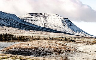
Ingleborough is the second-highest mountain in the Yorkshire Dales, England. It is one of the Yorkshire Three Peaks, and is frequently climbed as part of the Three Peaks walk. A large part of Ingleborough is designated as a Site of Special Scientific Interest and National Nature Reserve and is the home of a new joint project, Wild Ingleborough, with aims to improve the landscape for wildlife and people.
The Coast to Coast Walk is a long-distance footpath between the west and east coasts of Northern England, nominally 190-mile (306 km) long. Devised by Alfred Wainwright, it passes through three contrasting national parks: the Lake District National Park, the Yorkshire Dales National Park, and the North York Moors National Park. The current actual measured distance is reported as 182-mile (293 km).

Céüse is a limestone mountain in the Hautes-Alpes département of France near Gap and Sigoyer. The "Pic de Céüse" is at an elevation of 2,016 metres (6,614 ft), and the whole massif is included in the Natura 2000 protected area. The mountain has a distinctive large horseshoe-shaped cliff which contains some of the most extreme sport climbing routes in the world. It is also the site of a ski resort.

Cleeve Hill is the highest point both of the Cotswolds hill range and of the county of Gloucestershire, at 330 m (1,080 ft). It is located on Cleeve Common, which is a Site of Special Scientific Interest (SSSI) looked after by a small charity called Cleeve Common Trust. It commands a clear view to the west, over Cheltenham and the racecourse, over the River Severn and into Wales; and to the north over Winchcombe. It is a conspicuous outcrop on the edge of the limestone escarpment,. It is crossed by the Cotswold Way footpath.

Clogwyn Du'r Arddu, or "Cloggy", is a north-facing rhyolite set of cliffs located on the northern flank of Snowdon mountain. Cloggy is considered to be one of the best traditional climbing areas in Britain, and has been called "The shrine of British climbing", and a "crucible for the development of most of the finest climbers in Britain and the scene of many of their finest achievements".
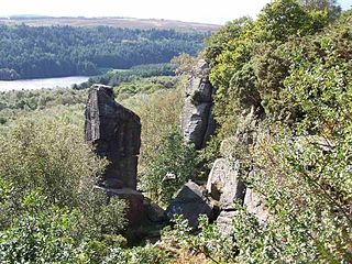
Rivelin Rocks are a gritstone edge or escarpment in the upper Rivelin Valley at grid reference SK279873, 9 kilometres (5.6 mi) west of Sheffield just off the A57 road in the county of South Yorkshire, England.
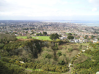
Dalkey Quarry is a long-disused 19th century granite quarry located on Dalkey Hill in the Dublin suburb of Dalkey, which was used to build several large maritime structures in south Dublin. Since passing into public ownership in the early 20th century and becoming part of Killiney Hill Park, it has become one of the most important rock climbing venues in Ireland, with over 350 graded routes, some of which are amongst the hardest single-pitch rock climbs in the country such as Indecent Assault. The climbs are all traditional climbing routes and no bolted sport climbing routes are permitted, although some metal pegs are tolerated on the most extreme routes.

Pot Hole quarry is a former limestone quarry close to Llanferres, near Mold, in Denbighshire, North Wales. The quarry is popular with rock climbers due to its rural setting, ease of access and selection of routes on good quality limestone. The average height of the quarried rock is approximately 12 metres (39 ft).

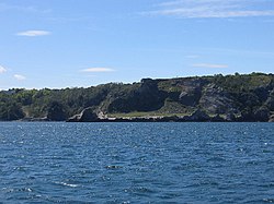
Ailladie, is an 800-metre-long (2,600 ft) west-facing limestone sea cliff, that varies in height from 8 metres (26 ft) to 35 metres (115 ft), situated on the coast of The Burren in County Clare, Ireland. Ailladie is one of Ireland's most highly regarded rock-climbing locations, particularly for high technical grade single pitch traditional climbing routes and deep-water soloing routes. It is also a location for shore-angling competitions, and, with its cliffs and view of the Aran Islands, is a popular photography stop for tourists.

Eldon Hill is a hill in the Peak District National Park in the county of Derbyshire, England, 4 kilometres (2.5 mi) southwest of the village of Castleton. It is a 470-metre (1,540 ft) limestone hill whose pastureland is used for rough grazing, although a large proportion has been lost to limestone quarrying. It lies within the Castleton Site of Special Scientific Interest. Eldon Hill was formed when a bed of pure limestone was squeezed and upfolded by geological forces to form a dome; it is the highest limestone hill north of the River Wye.
The Mendip Way is an 80-kilometre (50 mi) long-distance footpath across the Mendip Hills from Weston-super-Mare to Frome. It is divided into two sections.

Aill na Cronain is an inland west-facing limestone crag in The Burren in County Clare, Ireland. It is popular with novice rock climbers due to the number of short single-pitch 10–20 metre rock climbing routes in the S to HS rock climbing grades. It is beside the Aillwee Caves.

The Peak District Boundary Walk is a circular 190-mile (310 km) walking trail, starting and finishing at Buxton and broadly following the boundary of the Peak District, Britain's first national park. The route was developed by the Friends of the Peak District and was launched on 17 June 2017.

Chee Dale is a steep-sided gorge on the River Wye near Buxton, Derbyshire, in the Peak District of England.

Deep Dale is a short steep-sided gorge near Buxton, Derbyshire, in the Peak District of England. It is distinct from another Deep Dale, near Sheldon, 4 miles (6.4 km) to the east.

The Wye Valley is the limestone valley of the River Wye in the White Peak of Derbyshire, England. The source of the River Wye is west of Buxton on Axe Edge Moor. One main channel runs underground through Poole's Cavern. The river flows though Buxton Pavilion Gardens and then along a culvert under the town centre. After leaving the flat area of central Buxton, the Wye Valley becomes distinct as a gorge running east for 10 miles (16 km) before the valley broadens at Ashford-in-the Water.

Harthill Moor is a small upland area in the Derbyshire Peak District of central and northern England, lying between Matlock and Bakewell near the villages of Birchover and Elton. The moor is within the southern portion of Harthill civil parish. Its highest point is 272 metres (892 ft) above sea level. The River Bradford flows along the northern edge of the moor past Youlgreave and into the River Lathkill at Alport. Harthill Moor is a rich prehistoric landscape with several protected Scheduled Ancient Monuments.
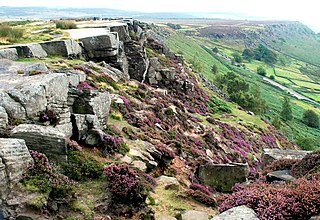
Curbar Edge is a gritstone moorland escarpment above the village of Curbar, in Derbyshire, England and close to the villages of Baslow, Calver, and Froggatt. It is located within the Peak District National Park at an altitude of 958 ft (292 m). It is regarded as a significant location for rock climbing, both regionally and nationally, in terms of both the historical development of the sport and as the location of first ascents.

Burbage Rocks is a gritstone escarpment in South Yorkshire, overlooking the village of Hathersage in the Peak District. The highest point along the escarpment is 429 metres (1,407 ft) above sea level, whilst Burbage Moor rises above to 438 metres (1,437 ft). Burbage Rocks is a southern extension of Stanage Edge. Burbage Brook runs from the northern end of the Burbage Rocks, past the southern end, through Padley Gorge and into the RIver Derwent.