Longfields

Last updated
Longfields
Neighbourhood
LongfieldsTransitStation Barrhaven 2012.jpg
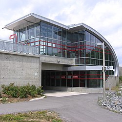
Longfields Transit Station Barrhaven, soon after it opened in 2012
Canada Ontario location map 2.svg
Red pog.svg
Longfields
Coordinates: 45°17′15″N75°44′00″W / 45.28750°N 75.73333°W / 45.28750; -75.73333 Coordinates: 45°17′15″N75°44′00″W / 45.28750°N 75.73333°W / 45.28750; -75.73333
CountryCanada
CityOttawa
WardBarrhaven
Area
  Total4.609 km2 (1.780 sq mi)
Population
 (2016)
  Total19,763
  Density4,300/km2 (11,000/sq mi)
  Canada 2016 Census [1]

Longfields is a neighbourhood in Barrhaven Ward in Ottawa, Ontario. This recent neighbourhood is located within the growing suburb of Barrhaven in the city's southwest and is bordered by Greenbank Road to the west, Strandherd Drive to the south, Woodroffe Avenue to the east, the CNR railway on the northwest and Fallowfield Road to the north. [2]

Contents

Longfields was mostly built in the early 1990s during a period of major expansion. Barrhaven's most recent high school, Longfields-Davidson Heights Secondary School, is located in this neighbourhood. Also, a station in the transitway corridor (also named Longfields) was built and opened in the Spring of 2011 .

There are also plans for major development south of Longfields with a large employment zone as well as a possible expansion of the O-Train north-south light rail project.

See also

Related Research Articles

Riverview, Ottawa Neighbourhood in Ottawa, Ontario, Canada

Riverview is a neighbourhood in Ottawa, Ontario, Canada. It is southeast of the downtown adjacent to the Rideau River, its location on which is its namesake. The 2016 Census population of Riverview is 12,218.

Cedarhill Estates is an neighbourhood located in Barrhaven Ward in the west end of Ottawa. Prior to amalgamation in 2001, it was located in Nepean. Together with Orchard Estates and the new Onassa Springs development, it located within the western part of the Ottawa Greenbelt. It is bordered by Fallowfield Road to the south, Cedarview Road to the east, and by Highway 416 to the north and west. It is located northwest of the growing Barrhaven suburb of the city. The neighbourhood surrounds the Cedarhill Golf Course. The neighbourhood by two nearby interchanges via Highway 416.

Nepean, Ontario Suburban district in Ottawa, Ontario, Canada

Nepean is a part of Ottawa, Ontario, located west of Ottawa's inner core. It was an independent city until amalgamated with the Regional Municipality of Ottawa–Carleton in 2001 to become the new city of Ottawa. However, the name "Nepean" continues in common usage in reference to the area. The population of Nepean is about 170,544 people.

Barrhaven Community in Ontario, Canada

Barrhaven is a rapidly growing suburban neighbourhood in the southwest of the urban area of the city of Ottawa, Ontario, Canada, about 17 km (11 mi) southwest of downtown Ottawa. Prior to amalgamation with Ottawa in 2001, Barrhaven was part of the City of Nepean. Its population as of the Canada 2016 Census was 87,234.

Embrun, Ontario Community in Ontario, Canada

Embrun, UN/LOCODE: CA EBU, is a community in the Canadian province of Ontario in the Eastern Ontario region. Embrun is also part of the National Capital Region. Embrun is part of the larger Russell Township in Prescott and Russell United Counties. In 2011, the urban area of Embrun had a total population of 6,380, but if surrounding agricultural areas closely tied to the community are included, the population figure rises to 8,669. This makes Embrun the largest community in the Township of Russell.

Hintonburg Neighbourhood in Ottawa, Ontario, Canada

Hintonburg is a neighbourhood in Kitchissippi Ward in Ottawa, Ontario, Canada, located west of the Downtown core. It is a historically working-class, predominantly residential neighbourhood, with a commercial strip located along Wellington Street West. It is home to the Parkdale Farmer's Market, located along Parkdale Avenue, just north of Wellington.

Merivale High School is a secondary school, located at the intersection of Merivale Road and Viewmount Drive in Ottawa, Ontario, Canada. The school is known for its International Baccalaureate student program, but also runs French Immersion programs and visual art, music, and co-operative education programs.

Woodroffe Avenue Road in Ottawa, Ontario, Canada

Woodroffe Avenue is a major north-south arterial road in Ottawa, Ontario, Canada's west end. It runs south from the Sir John A. Macdonald Parkway through Baseline Road and Barrhaven to just short of Prince of Wales Drive near Manotick. The road runs through the heart of Nepean in Ottawa's west end. A satellite Via Rail station is also located at the intersection of Fallowfield Road.

Lower Town Neighbourhood in Ottawa, Ontario, Canada

Lower Town (also spelled "Lowertown" is a neighbourhood in Rideau-Vanier Ward in central Ottawa, Ontario, Canada, to the east of downtown. It is the oldest part of the city. It is bounded by Rideau Street to the south, the Ottawa River to the west and north and the Rideau River to the east. It includes the commercial Byward Market area in the south-western part, and is predominantly residential in the north and east.

Merivale Road (Ottawa) road in Ottawa, Ontario, Canada

Merivale Road is an arterial road in the western part of Ottawa, Ontario, Canada. It starts at Island Park Drive just north of Highway 417 and continues south until it ends at Prince of Wales Drive in Rideau Glen. South of Clyde Avenue, Merivale is known as Ottawa Road #17, while north of Clyde it is Ottawa Road #63.

Riverside South, Ottawa Community in Ontario, Canada

Riverside South is a suburban community in Gloucester-South Nepean Ward in the south end of the city of Ottawa, Ontario, Canada, just southwest of Ottawa Macdonald-Cartier International Airport. Prior to amalgamation in 2001, the area was located in the city of Gloucester. Its population, according to the Canada 2016 Census, was 14,672.

Strandherd Drive is a major road serving the community of Barrhaven in southwest Ottawa.

Prince of Wales Drive road serving Ottawa, Ontario, named after the eponymous road in Battersea, London, U.K.

Prince of Wales Drive is a road serving Ottawa, Ontario, named after the eponymous road in Battersea, London, U.K. The northern section is a low-speed street running along the west bank of the Rideau River, while southern portions of the road were formerly Highway 16.

Architecture of Ottawa architectural style and prominent buildings in Ottawa, Canada

The architecture of Ottawa is most marked by the city's role as the national capital of Canada. This gives the city a number of monumental structures designed to represent the federal government and the nation. It also means that as a city dominated by government bureaucrats, much of its architecture tends to be formalistic and functional. However, the city is also marked by Romantic and Picturesque styles of architecture such as the Parliament Building's Gothic Revival architecture.

Marketplace is a Southwest Transitway station in the Barrhaven neighbourhood of Ottawa, Ontario, Canada. The station is located at the Riocan Marketplace shopping centre, an extensive commercial zone which contains big-box stores and department stores.

Riverview is an OC Transpo transit station located in the Riverside South community in Ottawa, Ontario. The station is located south of Earl Armstrong Road east of River Road.

Longfields station

Longfields is an Ottawa Transitway station in the Longfields neighbourhood of Ottawa, Ontario, Canada (Barrhaven). The station is located on a route that runs along the south side of the CNR railway line southwest from Fallowfield Station towards Strandherd Station.

Country Place is a residential neighbourhood near the geographical centre of Ottawa, Canada and part of the former city of Nepean. It is a mature residential subdivision with about 400 houses located just inside the Ottawa greenbelt near the Rideau River, and about 11 km from downtown Ottawa. It is bordered by the Black Rapids Creek and the greenbelt to the south, Prince of Wales Drive to the east, Merivale Road to the west, and the Pineglen community to the north. Amberwood Crescent meanders through the community, exiting onto Prince of Wales and Merivale. Tennyson Drive links Country Place to Pineglen.

References

  1. Population calculated by combining Census Tracts 5050141.11, 5050141.10, 5050141.05
  2. "The South Urban Community". Ottawa Citizen. February 24, 1990. p. I1. Retrieved May 23, 2020.