Rechytsa District, Rečycki Raion is a district of Gomel Region, in Belarus. Administrative center — Rechytsa.

Franz-Neumann-Platz is a Berlin U-Bahn station located on the U 8.

Sady nad Torysou is a new village and municipality in Košice-okolie District in the Kosice Region of eastern Slovakia.
Hyland Hills Ski Area is a ski area in Bloomington, Minnesota, United States, just south of Minneapolis. It is owned and operated by Three Rivers Park District. It is one of the three ski areas in the Twin Cities metropolitan area; the others are Afton Alps, and Buck Hill. While Minnesota's winters are cold, the average snowfall is low for a ski area, due to this, there is often use of Artificial snow to help maintain the viability of the slopes.

Kulata is a village in Petrich Municipality, Blagoevgrad Province, in southwestern Bulgaria. As of 2006 it has 892 inhabitants and the mayor is Dimitar Manolev. The village is a major border checkpoint on the border with Greece. The community of Promachonas in Serres regional unit lies across the border.
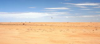
The Chalbi Desert is a small desert in northern Kenya near the border with Ethiopia. It is east of Lake Turkana and contains North Horr. Marsabit is the closest major city.
Krasnowo is a village in the administrative district of Gmina Sejny, within Sejny County, Podlaskie Voivodeship, in north-eastern Poland, close to the border with Lithuania.
Roughmussel is a district in the Scottish city of Glasgow. It is situated south of the River Clyde.

Michałowice is a village in the administrative district of Gmina Czarnocin, within Kazimierza County, Świętokrzyskie Voivodeship, in south-central Poland. It lies approximately 4 kilometres (2 mi) north-west of Czarnocin, 11 km (7 mi) north of Kazimierza Wielka, and 59 km (37 mi) south of the regional capital Kielce.
Gromadzice is a village in the administrative district of Gmina Bodzechów, within Ostrowiec County, Świętokrzyskie Voivodeship, in south-central Poland. It lies approximately 7 kilometres (4 mi) south-west of Ostrowiec Świętokrzyski and 52 km (32 mi) east of the regional capital Kielce.
Biele is a village in the administrative district of Gmina Sompolno, within Konin County, Greater Poland Voivodeship, in west-central Poland.
Komorze Nowomiejskie is a village in the administrative district of Gmina Nowe Miasto nad Wartą, within Środa Wielkopolska County, Greater Poland Voivodeship, in west-central Poland.
Czaple is a village in the administrative district of Gmina Żukowo, within Kartuzy County, Pomeranian Voivodeship, in northern Poland. It lies approximately 6 kilometres (4 mi) north-east of Żukowo, 16 km (10 mi) east of Kartuzy, and 14 km (9 mi) west of the regional capital Gdańsk.
Wormie is a village in the administrative district of Gmina Górowo Iławeckie, within Bartoszyce County, Warmian-Masurian Voivodeship, in northern Poland, close to the border with the Kaliningrad Oblast of Russia. It lies approximately 15 kilometres (9 mi) north-west of Górowo Iławeckie, 33 km (21 mi) north-west of Bartoszyce, and 66 km (41 mi) north of the regional capital Olsztyn.

Hajian Ki Dhok is a town in the Islamabad Capital Territory of Pakistan. It is located at 33°26′0″N73°21′50″E with an altitude of 544 metres (1,788 feet).

Brusnik is a village in the municipality of Ivanjica, Serbia. According to the 2011 census, the village has a population of 353 inhabitants.

Nasići is a village in the municipality of Breza, Bosnia and Herzegovina.
Männiku is a village in Märjamaa Parish, Rapla County in western Estonia.

Rilevo is a village in Municipality of Dolneni, central Republic of Macedonia.

Belogorka is a town in Aktobe Region, west Kazakhstan. It lies at an altitude of 340 m (1,120 ft).


