
Los Gatos is an incorporated town in Santa Clara County, California, United States. The population is 30,222 according to the 2019 United States Census Bureau. It is located in the San Francisco Bay Area at the southwest corner of San Jose in the foothills of the Santa Cruz Mountains. Los Gatos is part of Silicon Valley, with several high technology companies maintaining a presence there. Notably, Netflix, the streaming service and content creator, is headquartered in Los Gatos and has developed a large presence in the area.

Campbell is a city in Santa Clara County, California, and part of Silicon Valley, in the San Francisco Bay Area. As of the 2010 U.S. Census, Campbell's population is 39,349 and was estimated to be 41,793 in 2019.

The Guadalupe River mainstem is an urban, northward flowing 14 miles (23 km) river in California whose much longer headwater creeks originate in the Santa Cruz Mountains. The river mainstem now begins on the Santa Clara Valley floor when Los Alamitos Creek exits Lake Almaden and joins Guadalupe Creek just downstream of Coleman Road in San Jose, California. From here it flows north through San Jose, where it receives Los Gatos Creek, a major tributary. The Guadalupe River serves as the eastern boundary of the City of Santa Clara and the western boundary of Alviso, and after coursing through San José, it empties into south San Francisco Bay at the Alviso Slough.

The Los Gatos Creek Trail is a 9.7-mile (15.6 km) pedestrian and bicycle trail that runs through western Santa Clara County in California, from Lexington Reservoir in Los Gatos, California through Campbell, California to Meridian Avenue in San Jose, California alongside Los Gatos Creek. The trail is heavily used.

Vasona Lake County Park is a park located in Los Gatos, California and part of the Santa Clara County Parks system.
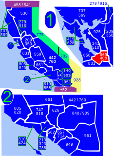
Area codes 408 and 669 are telephone area codes in the North American Numbering Plan (NANP) in the U.S. state of California. The numbering plan area comprises most of Santa Clara County and Northern Santa Cruz County, and includes Gilroy, Morgan Hill, Saratoga, Los Gatos, Monte Sereno, Milpitas, Sunnyvale, Santa Clara, Cupertino, Campbell, and San Jose.

The Peninsular Railway was an interurban electrified railway in the U.S. State of California in the United States of America. It served the area between San Jose, Los Gatos, and Palo Alto, comprising much of what is today known as "Silicon Valley". For much of its existence it was a subsidiary of the Southern Pacific Railroad.

Redwood Estates is a rural unincorporated community along State Route 17 in the coastal Santa Cruz Mountains in Los Gatos, California, United States. The Census Bureau includes it in a census-designated place named Lexington Hills. It lies inside the confines of Santa Clara County. The area is about eight miles from downtown Los Gatos and nine miles from the Santa Cruz County community of Scotts Valley.
San Antonio Creek may refer to any of the following waterways in California, United States:

The Los Gatos Creek runs 24 miles (39 km) in California through Santa Clara Valley Water District's Guadalupe Watershed from the Santa Cruz Mountains northward through the Santa Clara Valley until its confluence with the Guadalupe River in downtown San Jose. The Guadalupe River then continues onward into San Francisco Bay.
The Santa Clara Valley Water District provides stream stewardship, wholesale water supply and flood protection for Santa Clara County, California, in the southern San Francisco Bay Area. The district encompasses all of the county's 1,300 square miles (3,400 km2) and serves the area's 15 cities, 2 million residents and more than 200,000 commuters. The district's three water treatment plants can produce as much as 210,000,000 US gallons (800,000 m3) of drinking water a day. Another part of the district's mission is to manage flood and storm waters along the county's hundreds of miles of creeks and rivers in an environmentally sensitive manner.
El Rancho Rinconada de los Gatos was a 6,631-acre (26.83 km2) Mexican land grant in present-day Santa Clara County, California made in 1840 by Governor Juan Alvarado to Jose Maria Hernandez and Sebastian Fabian Peralta. Located in the southern San Francisco Bay Area, the grant included present-day Los Gatos and Monte Sereno, along with about a third of Campbell. It also included small sections of present-day San Jose, Saratoga and unincorporated Santa Clara County. Los Gatos Creek flowed through the center of the rancho. The name means "corner of the cats" and is derived from the cougars that are still present in the nearby hills, as well as the "corner" formed by the narrowing gap between El Sereno and El Sombroso mountains.

The Guadalupe watershed consists of 170 square miles (400 km2) of land within northern California's Santa Clara County. This watershed is owned and managed by the Santa Clara Valley Water District. The surface runoff from this area drains into the various rivers, streams, reservoirs or other bodies of water which all eventually gets carried into the San Francisco Bay. Essentially, all the water from the creeks and rivers that make up the Guadalupe watershed, including water from storm drains, flows into the Guadalupe River, and then flows downstream into the San Francisco Bay at the Alviso Slough in Alviso. The Guadalupe watershed's main tributaries include Los Gatos Creek, Trout Creek, Hendrys Creek, Ross Creek, Pheasant Creek, Rincon Creek, Herbert Creek, and Golf Creek. Six major reservoirs exist in the watershed: Calero Reservoir on Arroyo Calero, Guadalupe Reservoir on Guadalupe Creek, Almaden Reservoir on Los Alamitos Creek, Vasona Reservoir, Lexington Reservoir, and Lake Elsman on Los Gatos Creek.
Coyote Creek may refer to:

Lexington Reservoir is an artificial lake on the Los Gatos Creek near Los Gatos, California. The James J. Lenihan Dam, a 195 ft (59 m) high, 1,000 ft (300 m) thick earthen dam, forms the third-largest reservoir in Santa Clara County.

Los Gatos Creek Park is a county park in Campbell, California, a town that is bisected by the Los Gatos Creek. The park is operated by the Santa Clara County Parks and Recreation Department.
Los Gatos Creek may refer to:

San Tomas Aquinas Creek, known locally as San Tomas Aquino Creek, is a 16.5-mile-long (26.6 km) stream that heads on El Sereno mountain in El Sereno Open Space Preserve in Saratoga, California in Santa Clara County, California, United States. It flows north through the cities of Saratoga, Monte Sereno, Los Gatos, Campbell, Santa Clara and San Jose before its confluence with the Guadalupe Slough in south San Francisco Bay.
Vasona Reservoir is an artificial lake located in Los Gatos, California, United States. A 152-acre (62 ha) county park surrounds the reservoir and provides limited fishing, picnicking, and informal play activities. Although swimming is not allowed, human-powered boating is permitted in the reservoir.