Los Isidros

Last updated
Los Isidros
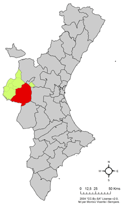
Localitzacio de Requena respecte del Pais Valencia.png
Requena in the Valencian Community
CountrySpain
Province Valencia
Municipality Requena
Comarca Requena-Utiel
Population
 (2015)
  Total337

Los Isidros is a village in Valencia, Spain. It is part of the municipality of Requena.

Coordinates: 39°25′N1°17′W / 39.417°N 1.283°W / 39.417; -1.283

Related Research Articles

Arctic Archipelago Group of islands in the Arctic Ocean, off the coast of northern Canada

The Arctic Archipelago, also known as the Canadian Arctic Archipelago, is an archipelago lying to the north of the Canadian continental mainland, excluding Greenland.

The 24th congressional district of Ohio was created for the 1966 election. It was eliminated in the redistricting following the 1970 census.

This is a list of the extreme points of Ireland – the points that are farthest north, south, east or west in Ireland. It includes the Republic of Ireland and Northern Ireland.

Molucca Sea marginal sea in the Pacific Ocean near Indonesia

The Molucca Sea is located in the western Pacific Ocean, around the vicinity of Indonesia, specifically bordered by the Indonesian Islands of Celebes (Sulawesi) to the west, Halmahera to the east, and the Sula Islands to the south. The Molucca Sea has a total surface area of 77,000 square miles. The Molucca Sea is rich in coral and has many diving sites due to the deepness of its waters. The deepness of the water explains the reasoning behind dividing the sea into three zones, which functions to transport water from the Pacific Ocean to the shallower seas surrounding it. The deepest hollow in the Molucca Sea is the 15,780-foot (4,810-meter) Batjan basin. This region is known for its periodic experiences of earthquakes, which stems from the sea itself being a micro plate, in which the Molucca Sea is being subducted in two opposite directions: one in the direction of the Eurasian Plate to the west and the other in the direction of the Philippines Sea Plate to the east.

Grenadines Parish Parish in Port Elizabeth, Saint Vincent and the Grenadines

Grenadines is an administrative parish of Saint Vincent and the Grenadines, comprising the islands of the Grenadines other than those belonging to Grenada. The capital is Port Elizabeth.

Casas de Garcimolina

Casas de Garcimolina is a municipality in Cuenca, Castile-La Mancha, Spain. It has a population of 39.

Castañar de Ibor Place in Extremadura, Spain

Castañar de Ibor is a municipality located in the province of Cáceres, Extremadura, Spain. According to the 2005 census (INE), it has a population of 1,182.

Garciaz municipality in Extremadura, Spain

Garciaz is a municipality located in the province of Cáceres, Extremadura, Spain. According to the 2006 census (INE), the municipality has a population of 902 inhabitants.

Palomero municipality in Extremadura, Spain

Palomero is a municipality located in the province of Cáceres, Extremadura, Spain. According to the 2007 census (INE), the municipality has a population of 498 inhabitants.

Sisante Place in Castile-La Mancha, Spain

Sisante is a municipality located in the Cuenca Province, Castile-La Mancha, Spain. According to the 2004 census (INE), the municipality has a population of 1,795 inhabitants.

Vara de Rey Place in Castile-La Mancha, Spain

Vara de Rey is a municipality located in the province of Cuenca, Castile-La Mancha, Spain. According to the 2004 census (INE), the municipality has a population of 637 inhabitants.

The Kugaryuak River is located in the Canadian Arctic territory of Nunavut in the southwest Kitikmeot Region. It forks into two entities, the Western Kugaryuak and the Eastern Kugaryuak and flows into Coronation Gulf.

Tountouroun Sub-prefecture and town in Labé Region, Guinea

Tountouroun is a town and sub-prefecture in the Labé Prefecture in the Labé Region of northern-central Guinea.

Dukat is a village in the municipality of Bosilegrad, Serbia. According to the 2002 census, the town has a population of 397 people.

Kovači, Raška Village in Raška District, Serbia

Kovači is a village in the municipality of Raška, Serbia. According to the 2002 census, the village has a population of 283 people.

Alexander Hill (Ross Island)

Alexander Hill is a 220-metre (720 ft) hill with a prominent seaward cliff face, lying south of Harrison Stream and Cinder Hill on the lower ice-free west slopes of Mount Bird, Ross Island, Antarctica. It was mapped by the New Zealand Geological Survey Antarctic Expedition, 1958–59, and named by the New Zealand Antarctic Place-Names Committee for B.N. Alexander, a surveyor with the expedition.

Chambers Glacier

Chambers Glacier is a glacier in the Forrestal Range of the Pensacola Mountains, draining east from Mount Lechner and Kent Gap, at the juncture of Saratoga Table and Lexington Table, to enter Support Force Glacier. It was discovered and photographed on January 13, 1956, on a transcontinental patrol plane flight of U.S. Navy Operation Deep Freeze I from McMurdo Sound to the vicinity of the Weddell Sea and return. It was named by the Advisory Committee on Antarctic Names after Captain Washington I. Chambers, U.S. Navy, one of the pioneers in the development of the airplane catapult for ships.

Tunovo is a village situated in Novi Pazar municipality in Serbia.