
Flathead County is in the U.S. state of Montana. At the 2020 census, its population was 104,357, making it the state's fourth most populous county. Its county seat is Kalispell. Its numerical designation is 7. Its northern border is on the state's north border, making it contiguous with the Canada–US border, facing British Columbia.
Columbia Falls is a city along the Flathead River in Flathead County, Montana, United States. The population was 5,308 at the 2020 census. Columbia Falls has been ranked as one of the best and safest places to live in Montana.
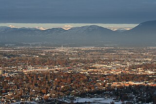
Kalispell is a city in Montana and the county seat of Flathead County, Montana, United States. The 2020 census put Kalispell's population at 24,558. In Montana's northwest region, it is the largest city and the commercial center of the Kalispell Micropolitan Statistical Area. The name Kalispell is a Salish word meaning "flat land above the lake"..

Whitefish is a city in Flathead County, Montana, United States. According to the 2020 United States Census, there were 7,751 people in the city.

The Flathead Indian Reservation, located in western Montana on the Flathead River, is home to the Bitterroot Salish, Kootenai, and Pend d'Oreilles tribes – also known as the Confederated Salish and Kootenai Tribes of the Flathead Nation. The reservation was created through the July 16, 1855, Treaty of Hellgate.

Flathead Lake is a large natural lake in northwest Montana.

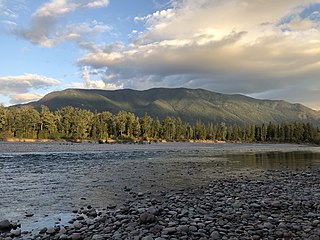
The Flathead River, in the northwestern part of the U.S. state of Montana, originates in the Canadian Rockies to the north of Glacier National Park and flows southwest into Flathead Lake, then after a journey of 158 miles (254 km), empties into the Clark Fork. The river is part of the Columbia River drainage basin, as the Clark Fork is a tributary of the Pend Oreille River, a Columbia River tributary. With a drainage basin extending over 8,795 square miles (22,780 km2) and an average discharge of 11,380 cubic feet per second (322 m3/s), the Flathead is the largest tributary of the Clark Fork and constitutes over half of its flow.

The Flathead National Forest is a national forest in the western part of the U.S. state of Montana. The forest lies primarily in Flathead County, south of Glacier National Park. The forest covers 2,404,935 acres of which about 1 million acres (4,000 km2) is designated wilderness. It is named after the Flathead Native Americans who live in the area.

The Swan River is a 95-mile (153 km) long, north-flowing river in western Montana in the United States. The river drains a long isolated valley, known as the Swan Valley, between the Swan Range on the east and the Mission Mountains to the west.

Lake McDonald is the largest lake in Glacier National Park. It is located at 48°35′N113°55′W in Flathead County in the U.S. state of Montana. Lake McDonald is approximately 10 miles (16 km) long, and over a mile (1.6 km) wide and 472 feet deep, filling a valley formed by a combination of erosion and glacial activity. Lake McDonald lies at an elevation of 3,153 feet (961 m) and is on the west side of the Continental Divide. Going-to-the-Sun Road parallels the lake along its southern shoreline. The surface area of the lake is 6,823 acres (27.6 km2).
The Flathead Valley is a region of the U.S. state located in the Northwestern Montana. It includes parts of Flathead County and Lake County. Notable communities include Kalispell, Bigfork, Whitefish, Columbia Falls, Polson, Ronan, and St. Ignatius. The geography of the Flathead roughly corresponds to the valley where Flathead Lake is located, with two distinct ends – the northern Flathead Valley and the southern (lower) Flathead Valley. In addition to Flathead and Whitefish lakes, the area's proximity to attractions such as Glacier National Park, Whitefish Mountain Resort, and Blacktail Mountain Ski Area have made the area a major summer and winter resort destination. Many outdoor activities can be pursued, including hiking, backpacking, boating, rafting, canoeing, skiing, hunting, and fly fishing. The lower Flathead Valley and the southern half of Flathead Lake are within the Flathead Indian Reservation and is home to the historic St. Ignatius Mission, founded in 1854.
The Whitefish River is a 24.8-mile-long (39.9 km) southward-flowing stream originating at the outlet of Whitefish Lake. The river is a tributary of the Stillwater River just before it reaches the Flathead River in Flathead County, in the U.S. state of Montana. The Whitefish River is part of the Columbia River basin, as the Flathead River is a tributary of Clark Fork, which is tributary to the Pend Oreille River, which is tributary to the Columbia River.
Lake Iroquois is a freshwater reservoir located in west Loda, Illinois in Iroquois County, 13.6 miles (21.9 km) from Onarga. The lake is 20–50 ft from Bayles Lake, the two lakes are separated by a road on the north side of Bayles Lake.

Whitefish Lake State Park is a 10-acre (4.0 ha) public recreation area on Whitefish Lake off of U.S. Highway 93, two miles northwest of Whitefish, Montana. It offers boating, swimming, tent and RV camping, and fishing. Sites for hike-in and bike-in camping were added in 2016.
North Valley Hospital is a private 501(c)(3) nonprofit general medicine and surgical Critical Access Hospital located in Whitefish, Montana. It is a state-designated community trauma center that serves Whitefish and the broader community of Flathead and Lincoln County. The hospital's chief executive officer is Kevin Abel, and it is affiliated with Kalispell Regional Healthcare. It is a member of the Planetree Alliance.

U.S. Highway 93 is a north–south United States Numbered Highway in the state of Montana.

Whitefish Lake ; is a natural oligotrophic freshwater lake in Flathead County, Montana, United States.
Tally Lake is a freshwater lake located in Flathead County, Montana in the northwestern region of the United States. The lake is about 20 miles west of the town of Whitefish. It is a popular lake for recreational activities including fishing, boating, swimming and cliff jumping, and hiking on the surrounding trails, and is notable for its great depth and unusual geology. The lake's surface area is over 1200 acres. The lake is located at roughly 3,500 feet above sea level. It is about 445 feet deep at its deepest point, making it the deepest lake in Montana and the deepest natural lake. Despite its large volume, the lake tends to be warm in late summer because its waters are darkly colored due to high levels of tannins. These cause the lake to absorb and retain more heat than comparatively clearer bodies of water in the region.
Lake Five is a freshwater lake in Flathead County, Montana, near the western entrance to Glacier National Park.
