
Rockall is an uninhabitable granite islet situated in the North Atlantic Ocean. The United Kingdom claims that Rockall lies within its exclusive economic zone (EEZ) and is part of its territory, but this claim is not recognised by Ireland. It and the nearby skerries of Hasselwood Rock and Helen's Reef are the only emergent parts of the Rockall Plateau. The rock was formed by magmatism as part of the North Atlantic Igneous Province during the Paleogene.

Saint Helena is an island in the South Atlantic Ocean, about midway between South America and Africa. St Helena has a land area of 122 square kilometres and is part of the territory of Saint Helena, Ascension and Tristan da Cunha which includes Ascension Island and the island group of Tristan da Cunha.

Bermuda is an overseas territory of the United Kingdom in the North Atlantic Ocean. Located off the east coast of the United States, it is situated around 1,770 km (1,100 mi) northeast of Miami, Florida, and 1,350 km (840 mi) south of Halifax, Nova Scotia, west of Portugal, northwest of Brazil, 1,759 km (1,093 mi) north of Havana, Cuba and north-northeast of San Juan, Puerto Rico. The nearest landmass is Cape Hatteras, North Carolina, about 1,030 km (640 mi) west-northwest, followed by Cape Sable Island, Nova Scotia, Canada 1,236 km northward. Although commonly referred to in the singular, the territory consists of approximately 138 islands, with a total area of 57 km2 (22 sq mi).
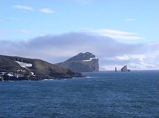
Deception Island is an island in the South Shetland Islands close to the Antarctic Peninsula with a large and usually "safe" natural harbor, which is occasionally troubled by the underlying active volcano. This island is the caldera of an active volcano, which seriously damaged local scientific stations in 1967 and 1969. The island previously held a whaling station. It is now a tourist destination with over 15,000 visitors per year. Two research stations are operated by Argentina and Spain during the summer season. While various countries have asserted sovereignty, it is still administered under the Antarctic Treaty System.

Baltimore is a village in western County Cork, Ireland. It is the main village in the parish of Rathmore and the Islands, the southernmost parish in Ireland. It is the main ferry port to Sherkin Island, Cape Clear Island and the eastern side of Roaring Water Bay and Carbery's Hundred Isles.

The Isle of Purbeck is a peninsula in Dorset, England. It is bordered by water on three sides: the English Channel to the south and east, where steep cliffs fall to the sea; and by the marshy lands of the River Frome and Poole Harbour to the north. Its western boundary is less well defined, with some medieval sources placing it at Flower's Barrow above Worbarrow Bay. John Hutchins, author of The History and Antiquities of the County of Dorset, defined Purbeck's western boundary as the Luckford Lake steam, which runs south from the Frome. According to writer and broadcaster Ralph Wightman, Purbeck "is only an island if you accept the barren heaths between Arish Mell and Wareham as cutting off this corner of Dorset as effectively as the sea." The most southerly point is St Alban's Head.

The Old Red Sandstone is an assemblage of rocks in the North Atlantic region largely of Devonian age. It extends in the east across Great Britain, Ireland and Norway, and in the west along the northeastern seaboard of North America. It also extends northwards into Greenland and Svalbard. These areas were a part of the ancient continent of Euramerica/Laurussia. In Britain it is a lithostratigraphic unit to which stratigraphers accord supergroup status and which is of considerable importance to early paleontology. For convenience the short version of the term, ORS is often used in literature on the subject. The term was coined to distinguish the sequence from the younger New Red Sandstone which also occurs widely throughout Britain.

The Tasman Peninsula, officially Turrakana / Tasman Peninsula, is a peninsula located in south-east Tasmania, Australia, approximately 75 km (47 mi) by the Arthur Highway, south-east of Hobart.

Valentia Island is one of Ireland's most westerly points. It lies off the Iveragh Peninsula in the southwest of County Kerry. It is linked to the mainland by the Maurice O'Neill Memorial Bridge at Portmagee. A car ferry also departs from Reenard Point to Knightstown, the island's main settlement, from April to October. Another, smaller village named Chapeltown sits at roughly the midpoint of the island, three kilometres from the bridge. Valentia Island's permanent population is 665. It is about 11 kilometres long by almost three kilometres wide, making it the fifth-biggest island off the Irish coast.
Sherkin Island, historically called Inisherkin, lies southwest of County Cork in Ireland alongside other islands of Roaringwater Bay. It had a population of 111 people at the time of the 2016 Census, and measures five kilometres long by 2.5 kilometres wide. The island has two pubs, a hotel, a bed and breakfast, a community centre, a coffee shop, and a Roman Catholic church.

Sully Island is a small tidal island and Site of Special Scientific Interest at the hamlet of Swanbridge, Vale of Glamorgan, 400 m (440 yd) off the northern coast of the Bristol Channel, midway between the towns of Penarth and Barry and 10 km (6 mi) south of the Welsh capital city of Cardiff.

HMS Hydra was a Royal Navy deep ocean hydrographic survey vessel, the third of the original three of the Hecla class. The ship was laid down as yard number 2258 on 14 May 1964 at Yarrow Shipbuilders, at Scotstoun on the River Clyde and launched on 14 July 1965 by Mary Lythall, wife of the then Chief Scientist, Basil W Lythall CB (1919–2001). She was completed and first commissioned on 4 May 1966 and, as the replacement for the survey ship HMS Owen, her commanding officer and many of her ship's company formed the first commission of HMS Hydra. She was decommissioned and sold to the Indonesian Navy in 1986 and renamed KRI Dewa Kembar ; she was still in service in 2019.

Tanah Lot is a rock formation off the Indonesian island of Bali. It is home to the ancient Hindu pilgrimage temple Pura Tanah Lot, a popular tourist and cultural icon for photography.
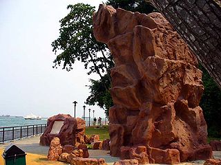
Long Ya Men or Dragon's Teeth Gate, is the name Chinese explorer Wang Dayuan recorded for Batu Belayar, a craggy granite outcrop that formerly stood at the gateway to Keppel Harbour in Singapore. In his description, “The strait runs between the two hills of the Danmaxi (Temasek) natives which looked like dragon’s teeth.” From there, the name Long Ya Men or Dragon Teeth’s Gate was born.

Sambro Island Lighthouse is a landfall lighthouse located at the entrance to Halifax Harbour, Nova Scotia, on an island near the community of Sambro in the Halifax Regional Municipality. It is the oldest surviving lighthouse in North America and its construction is a National Historic Event.

The Irish Sea is an extensive body of water that separates the islands of Ireland and Great Britain. It is linked to the Celtic Sea in the south by St George's Channel and to the Inner Seas off the West Coast of Scotland in the north by the North Channel. Anglesey, North Wales, is the largest island in the Irish Sea, followed by the Isle of Man. The term Manx Sea may occasionally be encountered.
The Baltimore Beacon is a white-painted stone beacon at the entrance to the harbour at Baltimore, County Cork, Ireland. The beacon was built at the order of the British government following the 1798 Rebellion. It was part of a series of lighthouses and beacons dotted around the Irish coast, forming a warning system.

In the Bible, Lot's wife is a figure first mentioned in Genesis 19. The Book of Genesis describes how she became a pillar of salt after she looked back at Sodom. She is not named in the Bible but is called "Ado" or "Edith" in some Jewish traditions. She is also referred to in the deuterocanonical books at the Book of Wisdom and the New Testament at Luke 17:32. Islamic accounts also talk about the wife of Prophet Lut (Lot) when mentioning 'People of Lut'.

Fort Charlotte is a British-colonial era fort, built on a hill over-looking the harbour of Kingstown, Saint Vincent. It is located in the parish of Saint Andrew, Saint Vincent and the Grenadines at the top of Edinboro road, on Berkshire Hill, just west of the town.

Ballyryan or Ballyreen is a small inland mostly west-facing limestone crag in The Burren in County Clare, Ireland. It is popular with rock climbers due to its easy access, the range of short easy-to-intermediate rock climbs, and its close proximity to the much larger and highly regarded, Ailladie rock-climbing sea-cliff; Ailladie is also locally known as the Ballyreen Cliffs or Ballyreen Point.