Baltimore Beacon | |
---|---|
Type | navigational beacon |
Location | Baltimore, County Cork |
Coordinates | 51°28′25″N9°23′16″W / 51.47360°N 9.38779°W |
Built | 1848 |
The Baltimore Beacon is a white-painted stone beacon positioned high above the channel between the mainland and Sherkin Island near the entrance to the harbour at Baltimore, County Cork, Ireland.
The structure is approximately 50 feet (15 m) high and 15 feet (4.6 m) in diameter at the base, and is situated on the top of a cliff, itself 160 feet (49 m) in height. [1] It is built of rubble stone into a tapered conical shape with a red-painted spherical metal finish on the top. [2] It constitutes part of a series of lighthouses and beacons dotted around the Irish coast to assist in marine navigation.
The beacon is locally known as "Lot's Wife", [2] after the Biblical woman turned into a pillar of salt. [3] The beacon has become a recognizable part of Baltimore's landscape, and one of the area's defining landmarks. [2] [1] The structure is featured on photographs and paintings of Baltimore. Southern Star newspaper's column with news from Baltimore and the area was titled "From Baltimore Beacon". [4] Local businesses adopted the beacon as a part of its name, with a notable example of Baltimore's now defunct Beacon Park Hotel. The feature is an attraction for tourists and day trip visitors, and "there is no end of people who get engaged", [1] and even married [5] there.
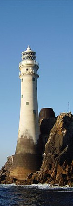
The beacon was built in 1848 after it had been noticed that an older warning beacon existing at the entrance of the Baltimore Harbour went into ruin. [6]
The wreck of a 17-century ship HMS Looe lies at the base of the beacon cliff. [6]
The decision to declassify the beacon as a navigational tool caused confusion in the 2010s as to who is the actual owner and as such should maintain the beacon, and in particular re-paint it in white. [7]
Baltimore is a village in western County Cork, Ireland. It is the main village in the parish of Rathmore and the Islands, the southernmost parish in Ireland. It is the main ferry port to Sherkin Island, Cape Clear Island and the eastern side of Roaring Water Bay and Carbery's Hundred Isles.
The Macquarie Lighthouse, also known as South Head Upper Light, is the first, and is the longest serving, lighthouse site in Australia. It is located on Dunbar Head, on Old South Head Road, Vaucluse in the Municipality of Woollahra local government area of New South Wales, Australia. The lighthouse is situated approximately 2 kilometres (1 mi) south of South Head near the entrance to Sydney Harbour. There has been a navigational aid in this vicinity since 1791 and a lighthouse near the present site since 1818. The current heritage-listed lighthouse was completed in 1883. The lighthouse and associated buildings were designed by James Barnet and built from 1881 to 1883.
Marblehead Lighthouse in Marblehead, Ohio, United States, is the oldest lighthouse in continuous operation on the American side of the Great Lakes. It has guided sailors safely along the rocky shores of Marblehead Peninsula since 1822, and is an active aid to navigation.
The Little Traverse Light is located in Emmet County in the U.S. state of Michigan on the north side of the Little Traverse Bay of Lake Michigan on Harbor Point in West Traverse Township near Harbor Springs, Michigan. It marks the entrance to the harbor at Harbor Springs.
Charles Fort is a trace italienne fortification, a bastion fort with one section of the outer wall built in star fashion. It is located at the southern end of the village of Summer Cove, on Kinsale harbour, County Cork, Ireland. First completed in 1682, Charles Fort was sometimes historically referred to as the "new fort" - to contrast with James' Fort which had been built on the other side of Kinsale harbour before 1607. The fort is now operated as a heritage tourism site by the Heritage Ireland arm of the Office of Public Works.
The Pensacola Light is a lighthouse at Pensacola Bay, in Florida. It is the third iteration of what was originally a lightship, the Aurora Borealis, and remains an aid to navigation.
The Boca Chita Key Historic District is a U.S. historic district within the Biscayne National Park in Miami-Dade County, Homestead, Florida. Located on the northwest section of Boca Chita Key, delimited by Biscayne Bay in the north and west and a half ruined stone wall on its southern side, it contains three historic buildings and the Boca Chita Lighthouse. On 1 August 1997, it was listed in the National Register of Historic Places for its architectural, historical and recreational values.
The Hook Lighthouse is a building situated on Hook Head at the tip of the Hook Peninsula in County Wexford, in Ireland. It is one of the oldest lighthouses in the world and the second oldest operating lighthouse in the world, after the Tower of Hercules in Spain. It is operated by the Commissioners of Irish Lights, the Irish lighthouse authority, and marks the eastern entrance to Waterford Harbour. The current structure has stood for over 800 years.
Kõpu Lighthouse is one of the best known symbols and tourist sites on the Estonian island of Hiiumaa. It is one of the oldest lighthouses in the world, having been in continuous use since its completion in 1531. The lighthouse is quite unique with its shape and exceptional among lighthouses because it has gone through all the stages from a medieval landmark up to a modern electrified lighthouse.
Rock Island is a promontory in West Cork, Ireland, situated about 2 kilometres (1.2 mi) south of the village of Goleen, at the entrance to the inlet of Crookhaven.
The Lighthouse of Praia da Barra, also known as the Aveiro Lighthouse, is an active lighthouse in the civil parish of Gafanha da Nazaré, municipality of Ílhavo, in the Portuguese district of Aveiro. Situated on the coastal Praia da Barra, at the southern margin of the Ria de Aveiro, it is the tallest lighthouse in Portugal, with a height of 203 feet (62 m) overseeing the barrier beach and exposed to Atlantic storms. It is open to the public and visits are held on Wednesdays from 14:00 to 17:00.
Cape Moreton Light, also listed as North Point Range Rear Light, is a heritage-listed active lighthouse located on Cape Moreton, a rocky headland located at the north eastern tip of Moreton Island, a large sand island on the eastern side of Moreton Bay, on the coast of South East Queensland, Australia. It marks the northern entrance to Moreton Bay and Brisbane and also serves as the rear light for the North Point Range. With its two distinctive red bands, it also serves as a daymark. It is the oldest lighthouse in Queensland, and the only one to be built by the New South Wales Government before the separation of Queensland, which took place in 1859. It is also the only lighthouse in Queensland to be built of stone.
Flat Top Island Light is an inactive lighthouse on Flat Top Island, a small island off the entrance to Mackay harbor at the mouth of Pioneer River, about 6.5 kilometres (4.0 mi) east of Mackay, Queensland, Australia. It used to mark the river entrance for shipping and the direction of the port, as well as highlighting close by shoals at Shoalwater Point and a reef off Hay Point. At 6 metres (20 ft) from the ground to the lantern floor, it is the shortest of Queensland's timber-framed iron clad lighthouses.
Roche's Point Lighthouse is situated at the entrance to Cork Harbour, Ireland. A lighthouse was first established on 4 June 1817 to guide ships into Cork Harbour. The original tower was deemed too small and in 1835 was replaced by the larger present tower which is 49 feet high with a diameter of 12 feet. Roche's Point Lighthouse, and a number of other structures, are located on a headland of the same name.
Low Point Lighthouse is an historic Canadian lighthouse marking the eastern entrance to Sydney Harbour at New Victoria, Nova Scotia, near New Waterford, Nova Scotia. This is one of the earliest and most important light stations of Nova Scotia, one of the first dozen beacons in Nova Scotia to be lit to guide mariners, a classic red-and-white lighthouse still operated by the Canadian Coast Guard.
The Spit Bank Lighthouse close to Cobh in County Cork, Ireland is a screw-pile lighthouse which marks a shallow bank in the navigable channels of lower Cork Harbour. The platform was built by the blind Irish engineer Alexander Mitchell, with the lighthouse itself designed by George Halpin. In use since its completion between 1851 and 1853, and renovated as recently as 2013, the landmark structure marks the boundary of compulsory pilotage for large vessels entering the Port of Cork.
The Inisheer, Inis Oírr or Fardurris Point Lighthouse, is an active 19th century lighthouse located on the island of Inisheer, the smallest of the Aran Islands, in County Galway, Ireland. It marks the south-eastern entrance to Galway bay and the port of Galway known as the South Sound, with a red sector of the light marking the Finnis Rock. The Eeragh Lighthouse which marks the North Sound entrance to the bay on the north-western side of the islands, was also constructed at the same time. Inisheer and Eeragh both became operational in 1857.
Eeragh Lighthouse is an active lighthouse located on Rock Island, one of the Brannock Islands, part of the Aran Islands archipelago in County Galway, Ireland. It marks the north-western entrance to Galway Bay and the port of Galway known as the North Sound. Due to its location it is also known as the Aran North Lighthouse. The lighthouse on Inisheer at the south-eastern end of the islands was also constructed at the same time. Eeragh and Inisheer both became operational in 1857.
Ballycotton Lighthouse is an active 19th century lighthouse positioned on Ballycotton Island, east of Ballycotton, County Cork, on the south coast of Ireland. The lighthouse is maintained by the Commissioners of Irish Lights and is listed on the National Inventory of Architectural Heritage as "a significant addition to the historical record and maritime heritage of Ireland".