John Rennie FRSE FRS was a Scottish civil engineer who designed many bridges, canals, docks and warehouses, and a pioneer in the use of structural cast-iron.

The Bell Rock Lighthouse, off the coast of Angus, Scotland, is the world's oldest surviving sea-washed lighthouse. It was built between 1807 and 1810 by Robert Stevenson on the Bell Rock in the North Sea, 11 miles (18 km) east of the Firth of Tay. Standing 35 metres (115 ft) tall, its light is visible from 35 statute miles (56 km) inland.
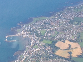
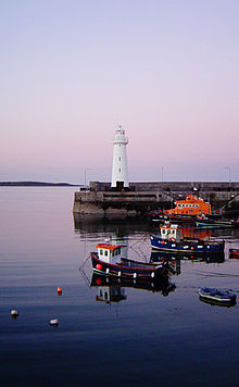
Donaghadee is a small town in County Down, Northern Ireland. It lies on the northeast coast of the Ards Peninsula, about 18 miles (29 km) east of Belfast and about six miles (10 km) south east of Bangor. It is in the civil parish of Donaghadee and the historic barony of Ards Lower. It had a population of 6,869 people in the 2011 Census.
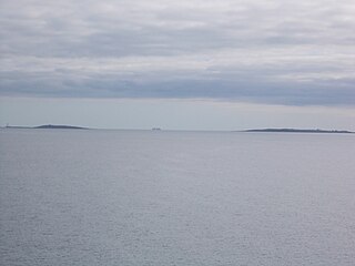
The Copeland Islands is a group of three islands in the north Irish Sea, north of Donaghadee, County Down, Northern Ireland, consisting of Lighthouse Island, Copeland Island, and Mew Island. They lie within the civil parish of Bangor.

The Rhins of Galloway, otherwise known as the Rhins of Wigtownshire, is a hammer-head peninsula in Dumfries and Galloway, Scotland. Stretching more than 25 miles from north to south, its southern tip is the Mull of Galloway, the southernmost point of Scotland.

Saint Peter Port Harbour is located in Saint Peter Port, Guernsey. It was a natural anchorage used by the Romans which has been changed into an artificial harbour that is now the island's main port for passengers. Loose cargo, liquids and gas are shipped to and from St Sampson's harbour.

Portpatrick is a village and civil parish in the historical county of Wigtownshire, Dumfries and Galloway, Scotland. It is located on the west coast of the Rhins of Galloway. The parish is about 4+1⁄2 miles (7 km) in length and 4 miles (6 km) in breadth, covering 9,300 acres (3,800 ha).

Toronto Harbour or Toronto Bay is a bay on the north shore of Lake Ontario, in Toronto, Ontario, Canada. It is a natural harbour, protected from Lake Ontario waves by the Toronto Islands. Today, the harbour is used primarily for recreational boating, including personal vessels and pleasure boats providing scenic or party cruises. Ferries travel from docks on the mainland to the Islands, and cargo ships deliver aggregates and raw sugar to industries located in the harbour. Historically, the harbour has been used for military vessels, passenger traffic and cargo traffic. Waterfront uses include residential, recreational, cultural, commercial and industrial sites.
Salt Island is joined to Holy Island, Anglesey, in North Wales. It is a natural provider of shelter for the town's Old Harbour from the Irish Sea and is part of the Port of Holyhead.
The Portpatrick and Wigtownshire Joint Railways was a network of railway lines serving sparsely populated areas of south-west Scotland. The title appeared in 1885 when the previously independent Portpatrick Railway (PPR) and Wigtownshire Railway (WR) companies were amalgamated by Act of Parliament into a new company jointly owned by the Caledonian Railway, Glasgow & South Western Railway, Midland Railway and the London & North Western Railway and managed by a committee called the Portpatrick and Wigtownshire Joint Committee.
Killough is a village and townland in County Down, Northern Ireland. It lies on the Irish Sea shore near Ardglass, five miles southeast of Downpatrick. It is a conservation area notable for its sycamore-lined main street. In the 2001 Census it had a population of 845 people.

Collyer Quay is a road in Downtown Core, Singapore that starts after Fullerton Road and ends at the junction of Raffles Quay, Finlayson Green and Marina Boulevard. The road houses several landmarks namely, Clifford Pier, Change Alley, Hitachi Tower, Ocean Towers and Ocean Financial Centre.
The Great South Wall, at the Port of Dublin, extends from the tip of the Poolbeg peninsula more than four kilometres out into Dublin Bay. It was the world's longest sea wall at the time of its construction and remains one of the longest in Europe. It faces the newer Bull Wall, and has one of four port lighthouses at its end.

Douglas Harbour is located near Douglas Head at the southern end of Douglas, the capital of the Isle of Man. It is the island's main commercial shipping port. The Port of Douglas was the first in the world to be equipped with radar.

Dún Laoghaire Harbour and Carlisle Pier were constructed in the nineteenth century for the purposes of sheltering ships and accommodating the mailboat which sailed between Dún Laoghaire and Holyhead. The nearby settlement of Dún Laoghaire has also previously been known as Kingstown and also as Dun Leary. Carlisle Pier has been known previously as Kingston Pier and the Mailboat Pier.

Holyhead Breakwater is situated at the north-western end of Holyhead on the island of Anglesey in North Wales. The Victorian structure, which is 1.7 miles (2.7 km) long, is the longest breakwater in the United Kingdom. The breakwater, which is accessible in good weather, has a promenade on top which leads out to the Holyhead Breakwater Lighthouse.
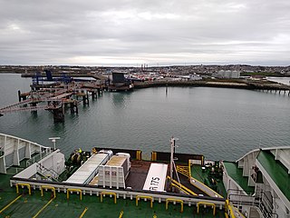
Cairnryan Harbour is a roll-on ferry terminal on Loch Ryan in south west Scotland north of Stranraer.
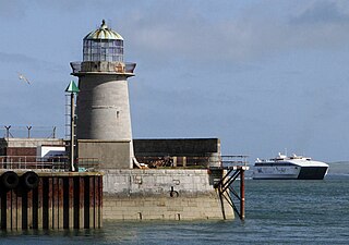
Holyhead Mail Pier or Admiralty Pier Lighthouse on Salt Island, Anglesey, is an inactive lighthouse which was designed by the civil engineer John Rennie in 1821. It was built in the early 19th century to help guide shipping into the newly constructed harbour, now known as the Port of Holyhead, which acted as the terminus for the packet service between England and Ireland. It is probably the second oldest lighthouse in Wales, after Point of Ayr Lighthouse and is the last of a series of three lighthouses located on Salt Island.

Wollongong Harbour Precinct is a heritage-listed shipping harbour at Cliff Road and Endeavour Drive, in Wollongong, New South Wales, Australia. It was built in 1837. The historic precinct includes Belmore Basin, Government Dam, Government Basin, Stockade Point, Flagstaff Hill, Signal Hill, Brighton Beach, Boat Harbour and Fortress Hill. It was added to the New South Wales State Heritage Register on 5 May 2010.
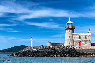
The Harbour lighthouse in Howth is an historic aid to navigation situated on the East pier of the harbour. It was built in the early 19th century to help guide shipping into the newly constructed harbour, which acted as the terminus for the packet service between Ireland and England. In 1982 it was decommissioned and replaced by a modern pole light on an adjacent extension of the pier.