Location | County Wexford |
---|---|
Coordinates | 52°12.175′N6°12.445′W / 52.202917°N 6.207417°W |
Tower | |
Constructed | 1812–1815 |
Construction | granite tower |
Automated | 31 March 1993 |
Height | 34 metres (112 ft) |
Shape | cylindrical tower with balcony and lantern |
Markings | white tower and lantern, red lantern rail |
Racon | T |
Light | |
First lit | 1815 |
Focal height | 33 metres (108 ft) |
Lens | Catoptric light (original), Chance Brothers 500-millimetre (20-inch) annular lens (current) |
Intensity | 1 kilowatt lamp |
Range | 24 nmi (44 km) |
Characteristic | Q (2) W 7.5s |
Ireland no. | CIL-0470 [1] [2] |
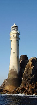
Tuskar Rock (Irish : An Tuscar) [3] is a group of rocks topped by a lighthouse 11 kilometres (6.8 miles) off the southeast coast of County Wexford, Ireland. The rocks have probably destroyed more ships than any other Irish coastal feature. [4] [5] One hundred and seventy-six wrecks are listed for the Tuskar Rock area at Irish Wrecks Online. [6]
The Tuskar Rock lighthouse, built from granite and standing 120 feet (37 metres) tall, was built over a period of years beginning in 1812. In October of that year, a storm struck, washing away temporary barracks that had been erected on the island, and killing fourteen workmen—the worst such disaster in Ireland's history of lighthouse construction. [7] The surviving workers clung to the island's slippery rocks for two full days before being discovered and rescued. [7] Work resumed, and the lighthouse was completed, entering into operation on 4 June 1815. [7]
The Tuskar Rock air disaster occurred near the rock on 24 March 1968 when Aer Lingus flight 712, en route from Cork to London, crashed into the sea with the loss of all 61 people on board.
The name Tuskar rock has no foundation in the Irish language but actually came from the Vikings. It is one of many Viking place names found in the south of Wexford and means simply large (tu) rock (skar) in Old Norse. [8]
Tuskar lighthouse is mentioned in John Masefield's ballad The Yarn of the Loch Achray as the place where the clipper Loch Achray dropped her tug, before sailing to the South Atlantic where she was wrecked off the River Plate.[ citation needed ]
|
| |||||||||||||||||||||||||||||||||||||||||||||||||||||||||||||||||||||||||||
Source: Central Statistics Office. "CNA17: Population by Off Shore Island, Sex and Year". irishislands.info. Retrieved 12 October 2016. |
Lightvessels in Ireland describes any lightvessel or light float previously stationed off the coast of Ireland. The Commissioners of Irish Lights are responsible for the majority of marine navigation aids around the whole of the island of Ireland.
Dursey Island lies at the southwestern tip of the Beara Peninsula in the west of County Cork in Ireland. Dursey Island is 6.5 kilometres long and 1.5 kilometres wide. The island is separated from the mainland by a narrow stretch of water, Dursey Sound, which has a very strong tidal race, with the submerged Flag Rock close to the centre of the channel.
Tearaght Island or Inishtearaght is an uninhabited steep rocky island west of the Dingle Peninsula in County Kerry, Ireland.
Fastnet Lighthouse is a 54-metre-tall (177 ft) lighthouse situated on the remote Fastnet Rock in the Atlantic Ocean. It is the most southerly point of Ireland and lies 6.5 kilometres (4.0 mi) southwest of Cape Clear Island and 13 kilometres (8.1 mi) from County Cork on the Irish mainland. The current lighthouse is the second to be built on the rock and is the tallest in Ireland.
Tusker Rock is a rock in the Bristol Channel, about 2 miles (3.2 km) west of Ogmore-by-Sea, Vale of Glamorgan, Wales. It is suggested that it takes its name from Tuska the Viking, a Dane whose fellow Vikings semi-colonised the Vale of Glamorgan. Alternatively, the name might derive simply from the Old Norse tu (large) skar (rock).
The Commissioners of Irish Lights, often shortened to Irish Lights or CIL, is the body that serves as the general lighthouse authority for Northern Ireland and the Republic of Ireland and their adjacent seas and islands. As the lighthouse authority for the island of Ireland it oversees the coastal lights and navigation marks provided by the local lighthouse authorities, the county councils and port authorities.
Aer Lingus Flight 712 crashed en route from Cork to London on 24 March 1968, killing all 61 passengers and crew. The aircraft, a Vickers Viscount 803 named St. Phelim, crashed into the sea off Tuskar Rock, County Wexford. Although the investigation into the crash lasted two years, a cause was never determined. Causes proposed in several investigative reports include possible impact with birds, a missile or target drone, or mechanical and structural failures.
The Chaine Memorial Tower in Larne, County Antrim, Northern Ireland, is a memorial to James Chaine, a former Member of Parliament for Antrim, who died in 1885. It is a cylindrical stone tower lighthouse with a conical roof, situated on the west side of entrance to Larne Lough.
The Hook Lighthouse is a building situated on Hook Head at the tip of the Hook Peninsula in County Wexford, in Ireland. It is one of the oldest lighthouses in the world and the second oldest operating lighthouse in the world, after the Tower of Hercules in Spain. It is operated by the Commissioners of Irish Lights, the Irish lighthouse authority, and marks the eastern entrance to Waterford Harbour. The current structure has stood for over 800 years.
Tralee Bay is located in on the west coast of County Kerry, Ireland. It is situated between Kerry Head on the north side and the Maharees on the west and extends eastwards as far as the bridge at Blennerville. Several small rivers feed into the bay through the town of Tralee. Villages around the bay include; Ballyheigue, Fenit, Kilfinora, Spa, Blennerville, Camp and Castlegregory.
Wicklow Head is a headland near the southeast edge of the town of Wicklow in County Wicklow, approximately 3 kilometres (2 mi) from the centre of the town.
The Kish Bank is a shallow sand bank approximately 11 kilometres (7 mi) off the coast of Dublin, in Ireland. It is marked by the Kish Lighthouse, a landmark visible to sailors and ferry passengers passing through Dublin Bay and Dún Laoghaire harbour.
The Maidens or Hulin Rocks are two islets and several skerries in the North Channel off County Antrim in Northern Ireland. The Eastern Maiden or Southern Rock lies about 9 km from the coast at Ballygalley, or 13 miles from Larne. The West Maiden or Northern Rock is about half a mile further out. Lighthouses were built on both rocks; the West Maiden was abandoned in 1903 and the East Maiden was automated in 1977.
Stephen Whitney was a passenger-carrying sailing ship which was wrecked on West Calf Island off the southern coast of Ireland on 10 November 1847 with the loss of 92 of the 110 passengers and crew aboard. She was a packet ship in Robert Kermit's Red Star Line. The ship was named after a Kermit investor, New York merchant Stephen Whitney.
Rock Island is a promontory in West Cork, Ireland, situated about 2 kilometres (1.2 mi) south of the village of Goleen, at the entrance to the inlet of Crookhaven.
Blacksod Lighthouse is a lighthouse at the southern end of the Mullet Peninsula, Erris, County Mayo, at the entrance to Blacksod Bay. It is made of local granite blocks, which are believed to have come from Termon Hill, a nearby isolated outcrop of high-quality granite.
Tuskar Rock may refer to one of the following:
The Maidens lighthouses, on the Maidens in North Channel off County Antrim in Northern Ireland, date from 1829 and were built at the request of merchants and a Royal Navy officer. Lighthouses were built on both rocks; the West Maiden was abandoned in 1903 and the East Maiden was automated in 1977.
The Haulbowline Lighthouse is an active 19th century lighthouse. Described as an "elegant, tapering stone tower" it is located at the entrance to Carlingford Lough, near Cranfield Point in County Down, Northern Ireland. The lighthouse was built on the eastern part of the Haulbowline rocks, one of a number of navigation hazards at the seaward end of Carlingford Lough, which include a notable rocky shoal or bar across the mouth of the lough. The multi-purpose light was designed to help mark the rocks and, when first built, the depth of water over the bar, as well as acting as a landfall light for ships entering from the Irish Sea. Associated with the lighthouse are the leading lights at Green Island and Vidal Bank which mark the safe channel along Carlingford Lough, with Haulbowline displaying a reserve light in case of problems with these leading lights.
The Spit Bank Lighthouse close to Cobh in County Cork, Ireland is a screw-pile lighthouse which marks a shallow bank in the navigable channels of lower Cork Harbour. The platform was built by the blind Irish engineer Alexander Mitchell, with the lighthouse itself designed by George Halpin. In use since its completion between 1851 and 1853, and renovated as recently as 2013, the landmark structure marks the boundary of compulsory pilotage for large vessels entering the Port of Cork.