
Warwick is a city in Kent County, Rhode Island, United States, and is the third largest city in the state with a population of 82,823 at the 2020 census. Warwick is located approximately 12 miles (19 km) south of downtown Providence, Rhode Island, 63 miles (101 km) southwest of Boston, Massachusetts, and 171 miles (275 km) northeast of New York City.

Cumberland is the northeasternmost town in Providence County, Rhode Island, United States, first settled in 1635 and incorporated in 1746. The population was 36,405 at the 2020 census, making it the seventh-largest municipality and the largest town in the state.

Greenville is a village and census-designated place (CDP) in the town of Smithfield in Providence County, Rhode Island, United States. The population was 8,658 at the 2010 census. The CDP is centered on the village of Greenville but also encompasses the nearby villages of West Greenville and Spragueville, as well as the Mountaindale Reservoir and beach.
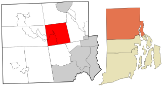
Lincoln is a town in Providence County, Rhode Island, United States. The population was 22,529 at the 2020 census. Lincoln is located in northeastern Rhode Island, north of Providence. Lincoln is part of the Providence metropolitan statistical area and the Greater Boston combined statistical area.

North Smithfield is a town in Providence County, Rhode Island, United States, settled as a farming community in 1666 and incorporated into its present form in 1871. North Smithfield includes the historic villages of Forestdale, Primrose, Waterford, Branch Village, Union Village, Park Square, and Slatersville. The population was 12,588 at the 2020 census.
Smithfield is a town that is located in Providence County, Rhode Island, United States. It includes the historic villages of Esmond, Georgiaville, Mountaindale, Hanton City, Stillwater and Greenville. The population was 22,118 at the 2020 census. Smithfield is the home of Bryant University, a private four year college.

Route 15 is a state highway in the U.S. states of Rhode Island and Massachusetts. The highway runs 8.3 miles (13.4 km) from U.S. Route 44 in North Providence, Rhode Island east through Pawtucket to the Massachusetts state line, where the highway continues for 0.23 miles (0.37 km) to Route 152 in Seekonk.

Route 146 is a 16.24-mile (26.14 km) north-south expressway in the U.S. state of Rhode Island, maintained by the Rhode Island Department of Transportation (RIDOT). Spanning approximately 16 miles (26 km) along a northwest–southeast axis, it links the cities of Providence, Woonsocket, and Worcester, Massachusetts.

Route 246 is a numbered state highway running 8 miles (13 km) in the U.S. state of Rhode Island. The Old Louisquisset Pike portion of the road was laid out through Louisquisset in 1682.

The Woonasquatucket River is a river in the U.S. state of Rhode Island. It flows approximately 15.8 miles (25.4 km) and drains a watershed of 130 km2 (50 sq mi).

Fox Island is an island in Narragansett Bay, Rhode Island, in the United States of America. It lies between Conanicut Island and North Kingstown just south of the village of Wickford, Rhode Island. The island is a part of the town of North Kingstown. The Native Americans called the island "Nanaquonset" The island was purchased from Native Americans by Randall Holden and Samuel Gorton in 1659. In the 1860s a Christian preacher named Captain Jimmie Hammond became the first full-time resident of the island where he lived with his chickens and cat. In 1880, Rev. William Pendleton Chapman, a pastor at the nearby Quidnessett Church, featured the island in his adventure book titled “Budd Boyd’s Triumph: The Boy Firm of Fox Island.” Various other private owners have owned the island since its first habitation. Since 2000 it has been privately owned by a corporation which uses a large wind generator on the east side of the island.
Norwood is a neighborhood in the city of Warwick, Rhode Island. Norwood is bounded by Route 37, the Pawtuxet River, Sherwood Avenue, the former Christopher Rhodes Elementary School, North Palm Boulevard, Palm Boulevard, and Post Road. Such borders mark the area traditionally served by the fire station previously located at the current site of the Norwood Boys & Girls Club.

Lime Rock (Limerock) is a village and historic district in Lincoln, Providence County, Rhode Island, United States, near Rhode Island Route 146. The village was named after the limestone quarries in the area, which started in the 17th century, and continue to the present where Conklin Limestone Company now operates. Because of the abundance of limestone in the area many houses had massive end chimneys and were called "stone enders," a distinctly Rhode Island style of architecture. The historic district includes 21 historically significant properties in an area extending from Wilbur Road, just west of its junction with Old Louisquisset Pike, eastward to Great Road, and then along Great Road as far as Simon Sayles Road. Among these properties are three quarries, and the ruins of three old lime kilns. It was listed on the National Register of Historic Places in 1974.

Arnold Mills Historic District is a historic district encompassing a modest 19th-century mill village in eastern Cumberland, Rhode Island. The district lies along the Nate Whipple Highway and Sneech Pond Road, south of the Arnold Mills Reservoir. Sneech Pond Road was formerly the major east-west highway through the area prior to the construction of the Nate Whipple Highway in the 1960s. The Arnold Mills village is in part bisected by Abbott Run, the stream which serves as the outlet of the reservoir; Sneech Pond Road crosses the run on an early 20th-century steel Pratt pony truss, now closed to vehicular traffic. The houses along this road generally date from the late 18th to mid-19th century, and mainly reflect Federal and Greek Revival styling. The most prominent structure in the district is the Arnold Mills United Methodist Church, located at the western end of the district on Nate Whipple Highway; it was built 1825-27 and remodeled in 1846.

The Wanskuck Historic District is a historic district in the city of Providence, Rhode Island encompassing a mill village with more than two hundred years of history. As early as the mid-18th century, mills stood on the West River in northern Providence, a development which continued with the rise of industrialization in the 19th century. The mill village of Wanskuck is organized around three thoroughfares: Branch Street, Veazie Street, and Woodward Road, and is roughly bounded on the east by Louisquisset Pike and to the northwest by the city line with North Providence. The West River runs through the district, with its banks lined by two late-19th-century mill complexes. The village area includes a variety of examples of mill worker housing, from duplexes to rowhouses, as well as two church complexes and a community hall built in 1884 by the Wanskuck Company.

The Lime Kilns of Lincoln, Rhode Island, are the remnants of three colonial-era lime kilns, all that is left of one of the oldest lime processing operations in North America. They are located respectively off Louisquisset Pike, Sherman and Dexter Rock Roads in an area that has been known for its lime processing since the 17th century. When originally built, they were roughly cylindrical structures fashioned out of unmortared rubble stone. The first kiln, whose ruins are located near the Flanagan campus of the Community College of Rhode Island west of Louisquisset Pike, was the largest of the three, nearly 20 feet (6.1 m) in diameter. The second kiln remains are located to the south of Sherman Avenue, near its junction with Louisquisset Pike. In 1984 the standing walls were 8 feet (2.4 m) high, with three recognizable openings. The third kiln, of which only a partial wall remains standing, is located on the south side of Dexter Rock Road.

Interstate 895 was a proposed Interstate Highway in Rhode Island and Massachusetts that would have supplemented Interstate 295 to create a full beltway around Providence.
Peter Mawney was a member of one of the few French Huguenot families that remained in Rhode Island, following violent clashes with the English citizens of East Greenwich, Rhode Island over disputed land. Mawney spent 24 years in the military service of the colony, serving in both the East Greenwich and Providence militias, and retiring as a colonel in the Providence County 2nd Regiment. He also served for many years as justice of the Peace for the town of East Greenwich.
John Whipple was an early settler of Dorchester in the Massachusetts Bay Colony, who later settled in Providence in the Colony of Rhode Island and Providence Plantations, where the family became well established.
