County Durham is a county in North East England. The county town is Durham, a cathedral city. The largest settlement is Darlington, closely followed by Hartlepool and Stockton-on-Tees. It borders Tyne and Wear to the north east, Northumberland to the north, Cumbria to the west and North Yorkshire to the south. The county's historic boundaries stretch between the rivers Tyne and Tees, thus including places such as Gateshead, Jarrow, South Shields and Sunderland.
England is a country that is part of the United Kingdom. It shares land borders with Wales to the west and Scotland to the north-northwest. The Irish Sea lies west of England and the Celtic Sea lies to the southwest. England is separated from continental Europe by the North Sea to the east and the English Channel to the south. The country covers five-eighths of the island of Great Britain, which lies in the North Atlantic, and includes over 100 smaller islands, such as the Isles of Scilly and the Isle of Wight.
Bishop Auckland is a market town and civil parish in County Durham in north east England. It is located about 12 miles (19 km) northwest of Darlington, 12 miles (19 km) southwest of Durham and 5 miles (8 km) southeast of Crook at the confluence of the River Wear with its tributary the River Gaunless. According to the 2001 census, Bishop Auckland has a population of 24,392, recounted at 16,296 for the 2011 Census. The difference in the two censuses is due to a change in the demarkations of the town boundaries over this period, rather than an actual reduction in the population.
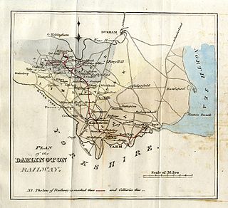
The Stockton and Darlington Railway (S&DR) was a railway company that operated in north-east England from 1825 to 1863. The world's first public railway to use steam locomotives, its first line connected collieries near Shildon with Stockton-on-Tees and Darlington, and was officially opened on 27 September 1825. The movement of coal to ships rapidly became a lucrative business, and the line was soon extended to a new port and town at Middlesbrough. While coal waggons were hauled by steam locomotives from the start, passengers were carried in coaches drawn by horses until carriages hauled by steam locomotives were introduced in 1833.
West Auckland is a village in County Durham, in North East England, to the west of Bishop Auckland on the A688 road. It is not known exactly when West Auckland was first inhabited, but there is evidence of Auckland West in the history of St. Cuthbert in the 11th century. The Boldon Book in 1183 showed that at that time West Auckland was inhabited by a number of serfs who were part of the tenantry of the Bishop of Durham, Hugh de Puiset, the first of the Prince Bishops. The creation of a church dedicated to St. Helen in the 13th century in Auckland West heralded the beginning of a separate community in what later became known as St. Helen Auckland. After the opening of the Stockton and Darlington railway in 1825, the search for coal escalated dramatically in the West Auckland area and the population increased as a consequence with the promise of employment. By the turn of the century, West Auckland colliery employed 620 men. The colliery closed in July 1967. The village of West Auckland is reputed to have one of the largest village greens in the country, lined with 17th and 18th-century buildings.
Witton Park Colliery was a coal mine in Witton Park, Witton-le-Wear near Bishop Auckland, County Durham, Northern England.
See also
Wikimedia Commons has media related to Low Etherley.
A geographic coordinate system is a coordinate system that enables every location on Earth to be specified by a set of numbers, letters or symbols. The coordinates are often chosen such that one of the numbers represents a vertical position and two or three of the numbers represent a horizontal position; alternatively, a geographic position may be expressed in a combined three-dimensional Cartesian vector. A common choice of coordinates is latitude, longitude and elevation. To specify a location on a plane requires a map projection.
This page is based on this Wikipedia article Text is available under the CC BY-SA 4.0 license; additional terms may apply. Images, videos and audio are available under their respective licenses.
Related Research Articles
The Weardale Railway is an independently owned British single-track branch line heritage railway between Bishop Auckland, Witton-le-Wear, Wolsingham, Frosterley and Stanhope. Weardale Railway began services on 23 May 2010, but decided to run special trains rather than a scheduled service for the 2013 season.
Phoenix Row incorporating Belts Gill and Softley Dene Farm is a hamlet of about 30 houses in County Durham, in England. It is situated half a mile north of Low Etherley and 2.5 miles west of Bishop Auckland.
High Etherley is a village in County Durham, England. It is situated on a hill approximately 4 miles west of Bishop Auckland.
Entering High Etherley on the A68 from West Auckland the village continues on the B6282 towards Bishop Auckland.
Houghton Bank is a village in the borough of Darlington and the ceremonial county of County Durham, England. It is situated a few miles west of Newton Aycliffe, on the A68 between Darlington and Bishop Auckland.
Escomb is a village on the River Wear about 11⁄2 miles (2.4 km) west of Bishop Auckland, County Durham, England. Escomb was a civil parish until 1960, when it and a number of other civil parishes in the area were dissolved.
Westgate is a village in County Durham, in North East England. It is situated in Weardale between St John's Chapel and Eastgate-In-Weardale.In the 2001 census Westgate had a population of 298.
Westgate is also the entrance to Slitt wood and an old abandoned lead mine. Other features of the village include a caravan site and a football and basketball court.
The Croesor Tramway was a Welsh, 2 ft narrow gauge railway line built to carry slate from the Croesor slate mines to Porthmadog. It was built in 1864 without an Act of Parliament and was operated using horse power.
Corkickle railway station serves the Whitehaven suburb of Corkickle in Cumbria, England. The railway station is a request stop on the scenic Cumbrian Coast Line 42 miles (68 km) south west of Carlisle. The station opened in 1855 and is at the southern end of the 3,999-foot (1,219 m) tunnel from Whitehaven railway station. At times it was known as 'Whitehaven Corkickle' station.
Shildon railway station is on the Stockton and Darlington Railway in North East England and serves the town of Shildon in County Durham, England built by Timothy Hackworth. The station is on the Tees Valley Line and is operated by Northern, which provides all passenger train services. The station is on the Bishop Line, 93⁄4 miles (15.7 km) north west of Darlington.
The New Zealand E class locomotive comprised a single steam locomotive operated by New Zealand Railways (NZR) from 1906 until 1917. Classified as E 66 and nicknamed Pearson's Dream after its designer, it was an experimental Mallet locomotive designed to work on the Rimutaka Incline. The "E" classification was previously used by the Double Fairlie E class of 1872-75, but the classification was free as they had all been withdrawn by the time E 66 entered service. After the withdrawal of E 66, "E" was again re-used on the battery-electric E class of 1922.
The Hetton colliery railway was an 8-mile (13 km) long private railway opened in 1822 by the Hetton Coal Company at Hetton Lyons, County Durham, England. It was the first railway to operate without animal power, and the first entirely new line to be developed by George Stephenson.
The Trefor Quarry railway was an industrial, 1 ft 111⁄2 in narrow gauge railway connecting the Trefor granite quarry with the pier at Llanaelhaearn on the Llŷn Peninsula.
West Stanley railway station was a railway station on the North Eastern Railway, in County Durham.
South Church railway station was on the Stockton and Darlington Railway.
Gaunless Bridge was a railway bridge on the Stockton and Darlington Railway. It was completed in 1823 and is one of the first railway bridges to be constructed of iron and the first to use an iron truss. It is also of an unusual lenticular truss design.
West Auckland railway station served the villages of St Helen Auckland and West Auckland in County Durham, England, between 1833 and 1962. It was on the railway line between Bishop Auckland and Barnard Castle. There was a locomotive depot, which was the only one to be both closed completely and later reopened by the London and North Eastern Railway.
Etherley railway station served the village of High Etherley in County Durham, North East England, from 1847 to 1965 on the Wear Valley line. It was briefly reopened during the summers of 1991 and 1992 as Witton Park.