Related Research Articles

Eswatini is a country in Southern Africa, lying between Mozambique and South Africa. The country is located at the geographic coordinates 26°30′S31°30′E. Eswatini has an area of 17,363 square kilometres, of which 160 are water. The major regions of the country are Lowveld, Midveld and Highveld.

Manzini is a region of Eswatini, located in the center-west of the country. It has an area of 4,093.59 km² and a population of 355,945 (2017), and is divided into 16 tinkhundla. Its administrative center is Manzini. It borders all three other regions: Hhohho in the north, Lubombo in the east, and Shiselweni in the south. It is bordered by the Mpumalanga province in South Africa to the west.

Shiselweni is a region of Eswatini, located in the south of the country. It has an area of 3,786.71 km² and a population of 204,111 (2017), and is divided into 14 tinkhundla. Its administrative center is Nhlangano. It borders Lubombo in the northeast and Manzini Region in the northwest.

Eswatini is divided into four regions: Hhohho, Lubombo, Manzini, and Shiselweni. Each region is further divided into tinkhundla. There are 55 tinkhundla in Swaziland and each elects one representative to the House of Assembly of Eswatini. Tinkhundla are, in turn, divided into smaller imiphakatsi.

iSimangaliso Wetland Park is situated on the east coast of KwaZulu-Natal, South Africa, about 235 kilometres north of Durban by road. It is South Africa's third-largest protected area, spanning 280 km of coastline, from the Mozambican border in the north to Mapelane south of the Lake St. Lucia estuary, and made up of around 3,280 km2 of natural ecosystems, managed by the iSimangaliso Authority. The park includes:
The Lubombo Transfrontier Conservation Area was born out of the Peace Park Foundation’s vision to establish a network of transfrontier conservation areas in southern Africa. It straddles the border between South Africa’s KwaZulu-Natal province, southern Mozambique, and Eswatini.
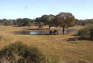
Tembe Elephant Park is a 30 012 ha game reserve in Maputaland, KwaZulu-Natal, South Africa. It is adjacent to Ndumo Game Reserve.
Siphofaneni is a town in the Lubombo Region of central Eswatini (Swaziland), 45 kilometres from Manzini and 20 kilometres from Big Bend, a major sugarcane-producing town on the main highway leading to Durban. It has a tropical climate, very hot during summer and cold in winter. Malaria is endemic in Lubombo. Siphofaneni has hot springs and is surrounded by several sugarcane farms. It is located on the banks of the largest river in Swaziland, the Usutu.
Mhlumeni is a town in eastern Eswatini on the border with Mozambique. It lies in the Lubombo Mountains about 40 kilometres north-east of Siteki in Lubombo District.

Simunye is a sugar mill town on the lowveld in eastern Eswatini. Almost all of the residents of the town work for the Royal Swaziland Sugar Corporation's sugar mill located nearby.
Mpaka is a town in eastern central Eswatini in western Lubombo District. It lies about 22 kilometres (14 mi) northwest of Siteki on the MR3 highway.

The Mthethwa Paramountcy, sometimes referred to as the Mtetwa or Mthethwa Empire, was a Southern African state that arose in the 18th century south of Delagoa Bay and inland in eastern southern Africa. "Mthethwa" means "the one who rules". According to Muzi Mthethwa (1995), the Mthethwas are descended from the Nguni tribes of northern Natal and the Lubombo Mountains, whose modern identity dates back some 700 years. They are among the first Thonga-Nguni groups who left the Great Lakes in Central Africa between 200 AD and 1200 AD. On arrival in Southern Africa, they settled around modern-day Swaziland, mainly on the Lubombo Mountains, before leaving in the 17th century to settle in modern-day KwaZulu-Natal, in the Nkandla region. It consisted of roughly 30 Nguni Chiefdoms, lineages, and clans. Unlike its successor, the Zulu Kingdom, the Mthethwa Paramountcy was a confederation. After Zulu prince Sigidi kaSenzagakhona became king, he forged a nearly homogeneous nation with a single king (nkosi).
Protected areas of Eswatini include any geographical area protected for a specific use inside the landlocked country of Eswatini, in southern Africa.

Malolotja National Park covers 18,000 hectares of mountain wilderness on Eswatini's northwestern border with South Africa. The park includes Ngwenya Mountain, Eswatini's second highest mountain, and Malolotja Falls which drop 89 metres (292 ft), the highest in Eswatini. Habitats include short grassland to thick riverine scrub, bushveld and Afromontane forest.
The Songimvelo-Malolotja Transfrontier Censervation Area is a peace park located on the South Africa - Eswatini border between Barberton and Pigg's Peak (Eswatini) and covers an area of approximately 700 square kilometres (270 sq mi), with potential extensions of another 500 square kilometres (190 sq mi).
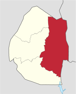
Lubombo is a region of Eswatini, located in the east of the country. It has an area of 5,849.11 km² and a population of 212,531 (2017). Its administrative center is Siteki. It borders all three other regions: Hhohho to the north, Manzini to the west, and Shiselweni to the south. It is divided into 11 tinkhundla.
Nsoko Airfield is an airstrip serving Nsoko, an agricultural village in the Lubombo Region of Eswatini. The runway is within the Nisela Game Reserve, 4 kilometres (2.5 mi) northeast of Nsoko, and 5 kilometres (3.1 mi) west of the South African border.
Siteki Airfield is an airstrip serving Siteki, a town in the Lubombo Region of Eswatini. The runway is 2 kilometres (1.2 mi) south of the town.
Tambuti Airfield is an airstrip serving the sugar plantation region around Big Bend, a town in the Lubombo Region of Eswatini. The airport is 16 kilometres (9.9 mi) west-northwest of Big Bend.
References
- ↑ Lawrence, Cecilia (2017). Swaziland: The Land and Its People. Intercontinental Books. p. 36. ISBN 9781981566525.
| This Eswatini location article is a stub. You can help Wikipedia by expanding it. |