Related Research Articles

The Democratic Republic of the Congo (DRC), also known as Congo-Kinshasa and formerly known as Zaire, is a country in Central Africa. By land area, the DRC is the second-largest country in Africa and the 11th-largest in the world. With a population of around 112 million, the Democratic Republic of the Congo is the most populous officially Francophone country in the world. The national capital and largest city is Kinshasa, which is also the economic center. The country is bordered by the Republic of the Congo, Central African Republic, South Sudan, Uganda, Rwanda, Burundi, Tanzania, Zambia, Angola, the Cabinda exclave of Angola and the South Atlantic Ocean.

Onchocerciasis, also known as river blindness, is a disease caused by infection with the parasitic worm Onchocerca volvulus. Symptoms include severe itching, bumps under the skin, and blindness. It is the second-most common cause of blindness due to infection, after trachoma.
Maniema Provinve is one of 26 provinces of the Democratic Republic of the Congo. Its capital is Kindu.

South Kivu is one of 26 provinces of the Democratic Republic of the Congo (DRC). Its capital is Bukavu.

Orientale Province is one of the former provinces of the Democratic Republic of the Congo and its predecessors the Congo Free State and the Belgian Congo. It went through a series of boundary changes between 1898 and 2015, when it was divided into smaller units.

The term Mai-Mai or Mayi-Mayi refers to any kind of community-based militia group active in the Democratic Republic of the Congo (DRC) that is formed to defend local communities and territory against other armed groups. Most were formed to resist the invasion of Rwandan forces and Rwanda-affiliated Congolese rebel groups, but some may have formed to exploit the war to their own advantage by looting, cattle rustling or banditry.
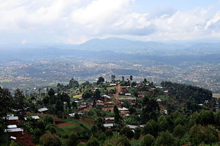
Butembo is a city in North Kivu, in the north eastern Democratic Republic of Congo, on the Rwenzori graben and west of Virunga National Park.The city is an important commercial centre with large markets, a cathedral, multiple large hospitals, and an airport. It is the city where live the most prosperous businessmen of the East of the country. The city is located in a region known for tea and coffee growing. As of 2022 it had an estimated population of 2,000,285.

Kindu is a city in the Democratic Republic of Congo, the capital of Maniema province. It has a population of about 200,000 and is situated on the Lualaba River at an altitude of about 500 metres, and is about 400 km west of Bukavu.

Masisi Territory is a territory which is located within the North Kivu Province of the Democratic Republic of the Congo. Its political headquarters are located in the town of Masisi.
Walikale Territory is a territory located within the Congolese province of North Kivu, in the eastern regions of the Democratic Republic of the Congo. The headquarters are in the town of Walikale. The locality is situated between Bukavu and Lubutu on DR Congo National Road No. 3 in the valley of the river Lowa, 135 km to the west of Goma.
Kalima is a town in Maniema Province, Congo. It is situated northeast of the provincial capital Kindu, between the Ulindi River and the Elila River, at an altitude of 2797 ft. The economic activity of Kalima and the surrounding area includes tin mining. In 2003 the town saw attacks by the Mai-Mai militias. Kalima has a hospital and is served by Kalima Airport. As of 2012, it had an estimated population of 48,337.
Kasongo, also known as Piani Kasongo, is a town and a Territory, located in the Maniema Province of the eastern Democratic Republic of the Congo.
United Front Against Riverblindness (UFAR) is a Non-Governmental Development Organization (NGDO) that provides technical, managerial and financial support for the elimination of riverblindness, or onchocerciasis, in the Kasongo region of Maniema province in the east-southern region of the Democratic Republic of the Congo (DRC).
Lubutu is a territory in Maniema province of the Democratic Republic of the Congo. The territory contains the southern portion of Maiko National Park. It is bordered to the north and west by Tshopo Province, to the east by North Kivu, and it is bordered to the south by Punia Territory, separated by the Lowa river. The main roads in the territory are the N3 and N31 highways, which intersect at the town of Lubutu. South of the village of Tingi-Tingi, a widened section of the N3 serves as the Tingi-Tingi Airport.
The Katanga insurgency is an ongoing rebellion by a number of rebel groups in the Democratic Republic of the Congo, some of which aim for the creation of a separate state within Katanga. While the insurgency has been active in various forms since 1963, insurgent groups have recently redoubled their efforts after the 2011 jail break that freed Gédéon Kyungu Mutanga, who commanded the majority of the Katangese separatist groups until his surrender to Congolese authorities in October 2016.
The 2017 CNPSC offensive was a military offensive launched by rebels of the National Coalition of the People for the Sovereignty of Congo (CNPSC) on 30 June 2017 against security forces of the Democratic Republic of the Congo and MONUSCO. The goal of the offensive was to capture major settlements, mainly in South Kivu province in order to raise support for a popular uprising against then-president Joseph Kabila, who the coalition had deemed as an illegitimate president.
Namoya Mine is an open pit gold mine in Maniema province of the Democratic Republic of the Congo (DRC) which started operations in 2016. Production has been disrupted by repeated attacks from rebel militias. The original Canadian owner sold to a Chinese consortium in 2020 due to security concerns.
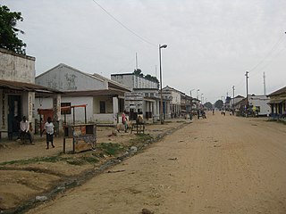
Kayuyu is a settlement in Maniema province, Democratic Republic of the Congo.
National Road 3 (N3) is a road in the Democratic Republic of the Congo. It runs from the city of Bukavu on the south end of Lake Kivu to the city of Kisangani.
Numbi is a town in Kalehe Territory in South Kivu province in the Democratic Republic of the Congo.
References
- ↑ World Health Organization. Consideration of national onchocerciasis control plans and project proposals (CDTI, vector elimination and headquarters support) approved in 2004. No. JAF10. 7. African Programme for Onchocerciasis Control, 2004.
- ↑ "Congo (Dem. Rep.): largest cities and towns and statistics of their population". World Gazetteer. Archived from the original on 2013-02-10.
- ↑ "Infrastructure challenges mining in Maniema" (PDF). itsci. July 2017. Retrieved 2023-03-19.
- ↑ "Maniema : Manifestation des opérateurs économiques à Lubutu". Actualite.cd (in French). 2019-05-09. Retrieved 2023-03-20.
- ↑ Shafy, Samiha (2015-03-16). "The History of a Congo Road Built Using German Aid Money". DER SPIEGEL. Retrieved 2023-03-21.
0°44′35″S26°35′00″E / 0.74306°S 26.58333°E
| | This Democratic Republic of the Congo location article is a stub. You can help Wikipedia by expanding it. |