Lung (river)

Last updated
Lung
Lung River at Crunnaun Bridge near Ballaghadereen, Co. Roscommon.jpg
Lung at Crunnaun Bridge
OSM Map of Lung River course.jpg
Lung in red but missing initial course from source in Urlaur Lough in south-west of map
Native nameAbhainn na Loinge (Irish) [1]
Physical characteristics
Mouth Lough Gara
  coordinates
53°55′13″N8°29′29″W / 53.9202°N 8.4915°W / 53.9202; -8.4915
Length18 miles

The Lung is a river in Ireland flowing through counties Mayo and Roscommon. [1] It runs in a generally north-easterly direction mainly through Mayo but also forms the border between the two counties in three places until it reaches Lough Gara near the town of Ballaghaderreen in County Roscommon. [2] The river and its lakes provides facilities for anglers to fish.

Contents

History

During the reign of King Irial, in the 12th century BC, the Lung became the natural boundary of the Luighne kingdom according to the Annals of the Four Masters and the borders were adopted by the modern Diocese of Achonry. The Lung Valley was ruled by the O’Hara's and O’Gara's until the 17th century. [3]

The Lung area was associated with the festival of Lughnasa held in August. The National Museum holds items recovered from the Lung, such as weapons, cauldrons, and drinking cups from the Bronze Age in a Galloglass section. Legend has it that items were ritually thrown into the river however, they could be the result of skirmishes. During the Norman invasion forts were erected along the river by the Costello's whose principal settlement was at Castelmore, about 2 miles from Ballaghaderreen. [3]

Under an 1840 act of Victoria, known as the County of Roscommon Act 1840, the Lord Lieutenant of Ireland was charged with annexing those non-contiguous townlands of counties Mayo and Roscommon to be combined with their respective counties thereby making the Lung the county boundary for those townlands. [4]

Geography

Urlaur Lough is where the Lung rises and flows about 22 km north-east to Lough Gara forming the Lung Valley. [5] Near Lough Glynn, the Lung runs underground for about a mile [6] and for the last 10 miles to Lough Gara it forms the boundary between counties Roscommon and Sligo. [7] After Ballaghaderreen the river joins Lough Gara at its western corner. [8]

In the 1840 the Lung was described as a slow meandering river occasionally forming turloughs and a mill situated about 3 miles upriver from Lough Gara would cease to function due to backwater. At that time the river banks and its basin were bogs. [7]

Besides the outflow lake of Lough Gara and the source lake Lough Urlaur, there are four other lakes, Lough Eritt, Lough Cloonaugh, Lough Loughglynn and Lough Cloonaholly, that make up the Lung Valley. [9]

Arterially drainage of the Lung took place over 35 years ago as far as Cloonroe Bridge, approximately 2 km from Errit Lough. [10]

Activities

The area is an angler's paradise, well served with access roads, parking, boat slips, fishing stands and walking trails as well as some facilities for physically impaired anglers. [11] Fishing is a pastime enjoyed along the river and at Lough Gara where the most bountiful fish are roach, followed by roach/bream hybrids, perch, pike, bream, eels and brown trout. [12]

"The Power House" of Ballaghaderreen generated electricity for the town from 1906 until 1933 though the first water powered turbine was installed in 1912 to harness the Lung for the power. Since decommissioning the building has been used as a science lab for the school, and later as a museum and art centre. [13]

Related Research Articles

<span class="mw-page-title-main">County Roscommon</span> County in Ireland

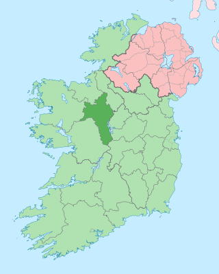
County Roscommon is a county in Ireland. It is part of the province of Connacht and the Northern and Western Region. It is the 11th largest Irish county by area and 27th most populous. Its county town and largest town is Roscommon. Roscommon County Council is the local authority for the county. The population of the county was 69,995 as of the 2022 census.

<span class="mw-page-title-main">County Longford</span> County in Ireland

County Longford is a county in Ireland. It is in the province of Leinster. It is named after the town of Longford. Longford County Council is the local authority for the county. The population of the county was 46,634 at the 2022 census. The county is based on the historic Gaelic territory of Annaly (Anghaile), formerly known as Teffia (Teathbha).

<span class="mw-page-title-main">Carrick-on-Shannon</span> Town in County Leitrim, Ireland

Carrick-on-Shannon is the county town of County Leitrim in Ireland. It is the largest town in the county of Leitrim. A smaller part of the town lies in County Roscommon. As of the 2022 census, the population of the town was 4,743. It is situated on a strategic crossing point of the River Shannon. The Leitrim part of the town is in the civil parish of Kiltoghert which is in the ancient barony of Leitrim.

<span class="mw-page-title-main">Roosky</span> Village in Leitrim and Roscommon, Ireland

Roosky, Ruskey, or Rooskey is a village on the River Shannon in the northern midlands of Ireland, near the point where counties Leitrim, Longford, and Roscommon meet. The N4 road from Dublin to Sligo passes by the Leitrim side of the village.

Monasteraden is a village in County Sligo, Ireland. The village is located on the shores of Lough Gara. St Aiden's church is the village's church. Other sites include Lough Gara Lodge, Slí na Croí's Roundhouse Ecolodge, Drury's pub and the general store.

<span class="mw-page-title-main">Drumsna</span> Village in County Leitrim, Ireland

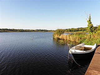
Drumsna is a village in County Leitrim, Ireland. It is situated 6 km east of Carrick-on-Shannon on the River Shannon and is located off the N4 National primary route which links Dublin and Sligo. The harbour dates to 1817 and was a hive of commercial waterway activity until the more northern navigation canal to Carrick-on-Shannon was opened in 1850. Today, the waterway is busy with anglers and tourist pursuits in the summer months.

<span class="mw-page-title-main">Costello (barony)</span> Ancient barony of Ireland

Costello is one of the ancient baronies of Ireland. Unusually for an Irish barony, it straddles two counties: County Mayo and County Roscommon. It comprises the modern day districts of Kilkelly, Kilmovee, Killeagh, Kilcolman, and Castlemore.

<span class="mw-page-title-main">Lough Gara</span>

Lough Gara is a lake in Counties Sligo and Roscommon, Ireland. It is an Important Bird Area protecting 1,788 ha of which most is covered by a Ramsar Site.

<span class="mw-page-title-main">Boyle River (Ireland)</span> Tributary of the Shannon in western Ireland

The Boyle River is a river in Ireland. Forming part of the Shannon River Basin, it flows from Lough Gara on the Sligo/Roscommon county border and thence through the town of Boyle to Lough Key. From there is continues eastwards through the village of Knockvicar to the River Shannon at Lough Drumharlow, near Carrick-on-Shannon. The length of the Boyle River is 64.4 km (40mi). The area of its basin is 725 km2.

<span class="mw-page-title-main">Lough Scur</span> Lake in south County Leitrim, Ireland

Lough Scur is a freshwater lake in south County Leitrim, northwest Ireland. It is part of the Shannon–Erne Waterway. There have been Human settlements here since the New Stone Age. Modern features include quays and moorings. Protected features are Castle John, three Crannogs, and the causeway into Rusheen Island, though "Jail Island" is not protected. The ecology of Lough Scur, and indeed all county Leitrim lakes, is threatened by pollution and invasive species such as curly waterweed, zebra mussel, and freshwater clam.

Lough Boderg is a lake on the River Shannon in County Roscommon and County Leitrim, Ireland.

<span class="mw-page-title-main">Lough Graney</span>

Lough Graney is a lake in County Clare, Ireland. The lake's outlet is the short River Graney, which flows through Lough O'Grady and past the town of Scarriff into the west side of Lough Derg.

Kilglass Lough is a freshwater lake in the west of Ireland. It is located in north County Roscommon.

<span class="mw-page-title-main">Lough Bofin (River Shannon)</span>

Lough Bofin is a lake on the River Shannon on the County Roscommon–County Leitrim border in Ireland.

<span class="mw-page-title-main">Urlaur Lough</span> Lake in County Mayo, Ireland

Urlaur Lough is a freshwater lake in the west of Ireland. It is located in east County Mayo and is one of the Urlaur Lakes.

Cavetown Lough is a freshwater lake in the west of Ireland. It is located in County Roscommon in the catchment of the upper River Shannon.

<span class="mw-page-title-main">Lisacul</span> Village in County Roscommon, Ireland

Lisacul is a village in County Roscommon, Ireland.

Carrickaport lough is a freshwater lake in Kiltubrid parish, south County Leitrim, Ireland. Drumcong village, and Lough Scur, lie nearby. Carrickaport lough is known for quality bream and pike fishing. The ecology of Carrickaport lough, and other county waterways, is threatened by curly waterweed, zebra mussel, and freshwater clam invasive species.

Keshcarrigan Lough is a mesotrophic freshwater lake near Keshcarrigan in County Leitrim, Ireland. Known for quality coarse fishing, the lake allows bank fishing from concrete stands on the northern shore, two with wheelchair access. The ecology of Keshcarrigan Lough, and other county waterways, is threatened by curly waterweed, zebra mussel, and freshwater clam invasive species.

<span class="mw-page-title-main">Rag River</span> River in County Cavan, Ireland

The Rag River is a river in County Cavan, Ireland. It rises in Mullaghdoo Lough, in the townland of Aghnacreevy, parish of Kildallan, and flows in a north-easterly direction through the lakes of Clonty Lough, Togher Lough, Lough Rud, Aghavoher Lough, Killywilly Lough, Cuillaghan Lough, Tomkinroad Lough, Lough Tee Lower and Corraback Lough. It discharges into the Shannon–Erne Waterway in the townland of Corraback. It has a fish population of pike, bream, rudd, roach, gudgeon and perch. Archaeological finds in the river include dugout canoes, socketed bronze axes and Irish elk antlers. The structures of interest along the river include Ardlougher Bridge, Greenville Corn Mill, Togher Bridge, Cranaghan Bridge, Killywilly Cavan & Leitrim Railway Level Crossing, Killywilly Corn Mill, Killywilly Bleach Mill, Killywilly Bridge, Tomkinroad Cavan & Leitrim Railway Bridge, Tomkinroad Cavan & Leitrim Railway Station & Level Crossing, Tomkinroad Creamery, Drumrush Corn Mill & Weir, Droghill Bridge, Feedarragh Bridge & Stepping Stones.

References

  1. 1 2 "Abhainn na Loinge". Placenames Database of Ireland. logainm.ie. 2023. Retrieved 8 June 2023.
  2. Joyce, Patrick Weston (1883). The geography of the counties of Ireland. London: George Philip & Son. pp. 153, 170. Retrieved 9 June 2023.
  3. 1 2 Sweeney, Myles (2023). "The Lung River: A Significant Historical Frontier". Lough Gara Lakes & Legends. Retrieved 17 January 2024.
  4. A Collection of the Public General Statutes: 1840. London: George E. Eyre & Andrew Spottiswoode. 1840. p. 558.
  5. Sampling Fish for the Water Framework Directive: Lakes 2010: Urlaur Lough (PDF), Inland Fisheries Ireland, 2010, p. 2, archived from the original (PDF) on 11 September 2014, retrieved 26 June 2023
  6. Lewis, Samuel (1837). A Topographical Dictionary of Ireland. London: S. Lewis & Co. pp. 525, 599.
  7. 1 2 The Parliamentary Gazetteer of Ireland: Adapted to the New Poor-law, Franchise, Municipal and Ecclesiastical Arrangements, and Compiled with a Special Reference to the Lines of Railroad and Canal Communication, as Existing in 1814-45, Volume 2. Dublin, London & Edinburgh: A. Fullarton and Company. 1846. p. 708.
  8. Joyce, Patrick Weston (1905). Atlas and cyclopedia of Ireland. New York: Murphy & McCarthy Publishers. p. 301.
  9. Cross, R.E. (1953). "Lough Gara: A Preliminary Survey". The Journal of the Royal Society of Antiquaries of Ireland. Dublin: Royal Society of Antiquaries of Ireland. 83 (1): 93–94. ISSN   0035-9106. JSTOR   25510850 . Retrieved 17 January 2024.
  10. "Errit Lough" (PDF). National Parks & Wildlife Service Conservation Statement 2009. Dublin: National Parks and Wildlife Service. 2009. Archived from the original (PDF) on 10 September 2014.
  11. "The Lung Valley". Angling. Lough Gara Lakes & Legends. 2023. Retrieved 9 June 2023.
  12. "Things to do". ballaghaderreen.com. 2021. Retrieved 8 August 2023.
  13. "Things to see". ballaghaderreen.com. 2021. Retrieved 8 August 2023.