
The Kariba Dam is a double curvature concrete arch dam in the Kariba Gorge of the Zambezi river basin between Zambia and Zimbabwe. The dam stands 128 metres (420 ft) tall and 579 metres (1,900 ft) long. The dam forms Lake Kariba, which extends for 280 kilometres (170 mi) and holds 185 cubic kilometres (150,000,000 acre⋅ft) of water.

The Zambezi is the fourth-longest river in Africa, the longest east-flowing river in Africa and the largest flowing into the Indian Ocean from Africa. Its drainage basin covers 1,390,000 km2 (540,000 sq mi), slightly less than half of the Nile's. The 2,574-kilometre-long (1,599 mi) river rises in Zambia and flows through eastern Angola, along the north-eastern border of Namibia and the northern border of Botswana, then along the border between Zambia and Zimbabwe to Mozambique, where it crosses the country to empty into the Indian Ocean.

Victoria Falls is a waterfall on the Zambezi River in southern Africa, which provides habitat for several unique species of plants and animals. It is located on the border between Zambia and Zimbabwe and is one of the world's largest waterfalls, with a width of 1,708 m (5,604 ft).

Lake Kariba is the world's largest artificial lake and reservoir by volume. It lies 1,300 kilometres (810 mi) upstream from the Indian Ocean, along the border between Zambia and Zimbabwe. Lake Kariba was filled between 1958 and 1963 following the completion of the Kariba Dam at its northeastern end, flooding the Kariba Gorge on the Zambezi River.

The Shire is the largest river in Malawi. It is the only outlet of Lake Malawi and flows into the Zambezi River in Mozambique. Its length is 402 kilometres (250 mi). The upper Shire River issues from Lake Malawi and runs approximately 19 km (12 mi) before it enters shallow Lake Malombe. It then drains Lake Malombe and flows south through Liwonde National Park where large concentrations of hippopotamus are common along its shores. Between the towns of Matope and Chikwawa, the middle river drops approximately 400 m (1,300 ft) through a series of falls and gorges, including Kapachira Falls. Two hydroelectric dams have been built along the Shire northwest of Blantyre.
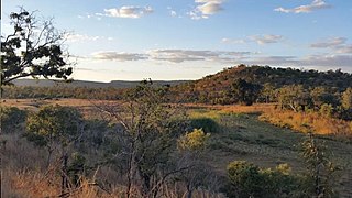
Chizarira National Park is a national park that lies in Northern part of Zimbabwe. At 2,000 square kilometres, it is the third-largest national park in Zimbabwe, and also one of the least known because of its isolated situation on the Zambezi Escarpment. It has good wildlife populations and some majestic scenery. The name of the park comes from the Batonga word chijalila, which translates into English as "great barrier", referring to Zambezi Escarpment, of which Chizarira’s rough terrain forms a part.

The Luangwa River is one of the major tributaries of the Zambezi River, and one of the four biggest rivers of Zambia. The river generally floods in the rainy season and then falls considerably in the dry season. It is one of the biggest unaltered rivers in Southern Africa and the 52,000 square kilometres (20,000 sq mi) that make up the surrounding valley are home to abundant wildlife.

The Victoria Falls Bridge crosses the Zambezi River just below the Victoria Falls and is built over the Second Gorge of the falls. As the river forms the border between Zimbabwe and Zambia, the bridge links the two countries and has border posts on the approaches to both ends, at the towns of Victoria Falls, Zimbabwe, and Livingstone, Zambia.

Livingstone is a city in Zambia. Until 1935, it served as the capital of Northern Rhodesia. Lying 10 km (6.2 mi) to the north of the Zambezi River, it is a tourism attraction center for the Victoria Falls and a border town with road and rail connections to Zimbabwe on the other side of the Victoria Falls. A historic British colonial city, its present population was enumerated at 177,393 inhabitants at the 2022 census. It is named after David Livingstone, the Scottish explorer and missionary who was the first European to explore the area. Until 2011, Livingstone was the provincial capital of Zambia's Southern Province.

The Munyati River is a river in Zimbabwe. Under the Rhodesian administration, it was officially named the Umniati, but its spelling was changed in 1983 to more closely resemble the correct Shona pronunciation.

Mana Pools National Park is a 219,600-hectare (543,000-acre) wildlife conservation area and national park in northern Zimbabwe. It is a region of the lower Zambezi in Zimbabwe where the floodplain turns into a broad expanse of lakes after each rainy season. As the lakes gradually dry up and recede, the region attracts many large animals in search of water, making it one of Africa's most renowned game-viewing regions.

The Lunsemfwa River is a tributary of the Luangwa Rivers in Zambia and part of the Zambezi River basin. It is a popular river for fishing, containing large populations of tigerfish and bream.

Mosi-oa-Tunya National Park is a UNESCO World Heritage Site that is home to one half of the Mosi-oa-Tunya — "The Smoke that Thunders", known worldwide as Victoria Falls — on the Zambezi River. The river forms the border between Zambia and Zimbabwe, so the falls are shared by the two countries, and the park is twin to the Victoria Falls National Park on the Zimbabwean side.
Zambezi Escarpment is a name used for the escarpments forming both sides of the rift valley or graben in which lie the middle Zambezi river and Lake Kariba. They are fault scarps, rising 500 to 600 m higher than the lake or river, running from the Batoka Gorge roughly 800 km to the lower Zambezi, and facing each other about 50 to 100 km apart, closer in the west and opening up in the east.

The Nyami Nyami, otherwise known as the Zambezi River God or Zambezi Snake Spirit, is one of the most important gods of the Tonga people. Nyami Nyami is believed to protect the Tonga people and give them sustenance in difficult times. The River God is usually portrayed as male.

The wildlife of Zimbabwe occurs foremost in remote or rugged terrain, in national parks and private wildlife ranches, in miombo woodlands and thorny acacia or kopje. The prominent wild fauna includes African buffalo, African bush elephant, black rhinoceros, southern giraffe, African leopard, lion, plains zebra, and several antelope species.

The wildlife of Zambia refers to the natural flora and fauna of Zambia. This article provides an overview, and outline of the main wildlife areas or regions, and compact lists of animals focusing on prevalence and distribution in the country rather than on taxonomy. More specialized articles on particular groups are linked from here.
Kariba Gorge is a large, natural gorge through which flowed the Zambezi River on the border of Zambia and Zimbabwe, Africa. In 1959 the large double arch concrete Kariba Dam was completed, completely filling the gorge and creating the largest man-made lake in the world. Lake Kariba was filled between 1958 and 1963 following the completion of the Kariba Dam at its northeastern end, flooding the Kariba Gorge on the Zambezi River and displacing large numbers of wildlife and the local Tonga people.
Operation Noah was a wildlife rescue operation on the Zambezi River, lasting from 1958 to 1964. In the late 1950s, North and South Rhodesia constructed the Kariba Dam hydroelectric power station across the Zambezi River, at the Kariba Gorge, about 400 km from Victoria Falls. The Kariba Dam mostly provided electric power to both countries, created Lake Kariba, the world's largest man-made lake, and flooded the Kariba Gorge - home to thousands of native animals and the local Tonga people. In a wildlife rescue operation lasting 5 years, over 6000 animals were rescued and relocated to the mainland.
The proposed Batoka Gorge Hydroelectric Power Station is a 2400 MW hydroelectric power station, planned for the Zambezi River on the international border between Zambia and Zimbabwe.

