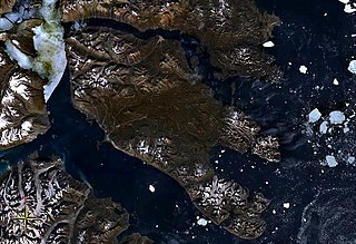
Lyell Land

Last updated
Lyell Land
Greenland edcp location map.svg
Red pog.svg
Lyell Land
Geography
LocationEast Greenland
Coordinates 72°36′N25°45′W / 72.600°N 25.750°W / 72.600; -25.750 Coordinates: 72°36′N25°45′W / 72.600°N 25.750°W / 72.600; -25.750
Adjacent bodies of water
Length60 km (37 mi)
Width50 km (31 mi)
Highest elevation2,200 m (7,200 ft)
Administration
Greenland (Denmark)
Zone NE Greenland National Park
Demographics
PopulationUninhabited

Lyell Land is a peninsula in East Greenland. It is located in the King Oscar Fjord area. Administratively it is part of the Northeast Greenland National Park zone.

Greenland Autonomous country within the Kingdom of Denmark

Greenland is an autonomous country of the Kingdom of Denmark, located between the Arctic and Atlantic oceans, east of the Canadian Arctic Archipelago. Though physiographically a part of the continent of North America, Greenland has been politically and culturally associated with Europe for more than a millennium. The majority of its residents are Inuit, whose ancestors began migrating from the Canadian mainland in the 13th century, gradually settling across the island.

King Oscar Fjord fjord in Greenland

King Oscar Fjord is a fjord in East Greenland, marking the northern border of the Scoresby Land Peninsula.

Northeast Greenland National Park national park

Northeast Greenland National Park is the world's largest national park and the 9th largest protected land area. Established in 1974 and expanded to its present size in 1988, it protects 972,000 km2 (375,000 sq mi) of the interior and northeastern coast of Greenland and is bigger than all but twenty-nine countries in the world. It was the first national park to be created in the Kingdom of Denmark and remains Greenland's only national park. It is the northernmost national park in the world.

It was named by Swedish Arctic explorer A.G. Nathorst on his 1899 expedition after Scottish geologist Charles Lyell (1797–1875). [1]

Alfred Gabriel Nathorst Swedish explorer and geologist

Dr Alfred Gabriel Nathorst HFRSE FLS FGS was a Swedish Arctic explorer, geologist and palaeobotanist.

Charles Lyell British lawyer and geologist

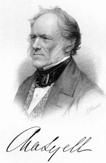
Sir Charles Lyell, 1st Baronet, was a Scottish geologist who demonstrated the power of existing natural causes in explaining Earth history. He is best known as the author of Principles of Geology, which presented for a wide public audience the idea that the Earth was shaped by the same natural processes still in operation today, operating at similar intensities. The philosopher William Whewell termed this gradualistic view "uniformitarianism" and contrasted it with catastrophism, which had been championed by Georges Cuvier and was better accepted in Europe. The combination of evidence and eloquence in Principles convinced a wide range of readers of the significance of "deep time" for understanding the Earth and environment.

Geography

Lyell Land is bounded by Kempe Fjord in the north —beyond which lies Suess Land, its branch Rhedin Fjord in the northwest, Narwhal Sound in the northeast —beyond which lies Ella Island, the King Oscar Fjord in the east —opposite Traill Island, Segelsällskapets Fjord to the southeast and Forsblad Fjord —beyond which lies Nathorst Land, in the south. Its northernmost headland is Cape Alfred. At the western end flows the Wahlenberg Glacier and the peninsula is attached to the mainland in the southwest, on the southern side of the glacier. [2]

Ella Island island in Greenland

Ella Island, or Ella Ø, is an island in eastern Greenland, within Northeast Greenland National Park.

Traill Island large island in eastern Greenland

Traill Island is a large island in eastern Greenland. It is named after zoologist Thomas Stewart Traill. The island is a part of the Northeast Greenland National Park.

Nathorst Land (Greenland) Region in Greenland

Nathorst Land is an area of Eastern Greenland. It lies in the Northeast Greenland National Park zone. The area is remote and uninhabited.

The Argand Glacier, the Polhem Valley and the Berzelius Bjerg massif, are some of the outstanding features of the peninsula. [1]

Related Research Articles

Kaiser Franz Joseph Fjord fjord in Greenland

Kaiser Franz Joseph Fjord is a major fjord system in the NE Greenland National Park area, East Greenland.

Andrée Land (Greenland) peninsula in Greenland

Andrée Land is a peninsula in King Christian X Land, East Greenland that is bounded by Kejser Franz Joseph Fjord, Isfjord and Geologfjord.

Renland peninsula in Greenland

Renland is a peninsula in eastern Greenland. It is a part of the Sermersooq municipality. Despite its proximity to the coast Renland has an ice cap climate with bitterly cold winters and very low maximum temperatures in the summer.

Kangerlussuaq Fjord, East Greenland Fjord Greenland, Sermersooq

Kangerlussuaq Fjord is a fjord in eastern Greenland. It is part of the Sermersooq municipality.

Hinksland peninsula in Greenland

Hinksland is a peninsula in eastern Greenland. It is a part of the Northeast Greenland National Park.

King Frederick VIII Land Region in Greenland

King Frederick VIII Land is a major geographic division of northeastern Greenland. It extends above the Arctic Circle from 76°N to 81°N in a N/S direction along the coast of the Greenland Sea.

Thorland

Thorland is a peninsula in the King Frederick VI Coast, southeastern Greenland. It is a part of the Sermersooq municipality.

Romer Lake

Romer Lake is a land-locked freshwater fjord at the northern end of King Frederick VIII Land, near Greenland's northeastern coast. The Danish military base/weather station Nord —the only inhabited place in the area— lies 50 km (31 mi) to the northeast. The lake and its surroundings are part of the Northeast Greenland National Park zone.

Petermann Peak mountain in Northeast Greenland National Park Greenland

Petermann Peak,, also known as Petermann Fjeld, Petermanns Topp and Petermann Point is a mountain in King Christian X Land, Northeast Greenland. Administratively it is part of the Northeast Greenland National Park zone.

Adolf S. Jensen Land peninsula in Greenland

Adolf S. Jensen Land is a peninsula in the southern limit of King Frederick VIII Land, northeastern Greenland. Administratively it belongs to the NE Greenland National Park area.

Scoresby Land Region in Greenland

Scoresby Land is an area of Eastern Greenland, which lies partly in Sermersooq and partly in the Northeast Greenland National Park zone. The area is uninhabited, except for Mestersvig, a military outpost.

Freuchen Land

Freuchen Land is a peninsula in far northwestern Greenland. It is a part of the Northeast Greenland National Park.

Wulff Land

Wulff Land is a peninsula in far northwestern Greenland. Administratively it is a part of the Northeast Greenland National Park.

Antarctic Sound, Greenland

The Antarctic Sound is a sound in King Christian X Land, Northeast Greenland. Administratively it is part of the Northeast Greenland National Park zone.

Nordvestfjord fjord in Greenland

Nordvestfjord, meaning 'Northwest Fjord', is a fjord in King Christian X Land, eastern Greenland.

Th. Sørensen Land Region in Greenland

Th. Sørensen Land is an area of Eastern Greenland, part of the Scoresby Sound system. It lies in the Northeast Greenland National Park zone. The area is remote and uninhabited.

References

  1. 1 2 "Catalogue of place names in northern East Greenland". Geological Survey of Denmark. Retrieved 7 July 2019.
  2. "Lyell Land". Mapcarta. Retrieved 7 July 2019.