Lyset

Last updated
A row of houses at Carl Langes Vej Lyset i Valby (Carl Langes Vej).JPG
A row of houses at Carl Langes Vej

Lyset (English: "The Light") is an area of building society houses located on the north side of Vigerslev Allé in the Valby district of Copenhagen, Denmark. The development consists of 106 houses situated along Carl Langes vej, Steenbergsvej, Fengersvej, Eschrichtsvej and Steinsvej, just west of Valby station and south of the railway line towards Roskilde.

A building society is a financial institution owned by its members as a mutual organization. Building societies offer banking and related financial services, especially savings and mortgage lending. Building societies exist in the United Kingdom and Australia, and used to exist in Ireland and several Commonwealth countries. They are similar to credit unions in organisation, though few enforce a common bond. However, rather than promoting thrift and offering unsecured and business loans, the purpose of a building society is to provide home mortgages to members. Borrowers and depositors are society members, setting policy and appointing directors on a one-member, one-vote basis. Building societies often provide other retail banking services, such as current accounts, credit cards and personal loans. The term "building society" first arose in the 18th century in Great Britain from cooperative savings groups.

Vigerslev Allé

Vigerslev Allé is a major artery in the Valby district of Copenhagen, Denmark. It runs from Enghavevej in the northeast to Hvidovrevej in Hvidovre in the southwest. The first part of the street runs east-west, following the south side of the main railway line through Copenhagen on its way to Toftegårds Plads, the largest square in Valby. It later passes under the S-train network's Ring Line at Vigerslev Allé station before continuing southwest to the Ring 2 ring road just before entering Hvidovre Municipality at Harrestrup Å in Vigerslevparken.

Valby district of Copenhagen, Denmark

Valby  is one of the 10 official districts of Copenhagen, Denmark. It is in the southwestern corner of Copenhagen Municipality, and has a mixture of different types of housing. This includes apartment blocks, terraced housing, areas with single-family houses and allotments, plus the remaining part of the old Valby village, around which the district has formed, intermingled with past and present industrial sites.

Contents

History

The building society Lyset was founded on 24 September 1910 at the initiative of employees at Copenhagen's tramways to provide modern and healthy homes outside the dense inner city for the members. Since they were too few to lift the project, the society was also opened to employees as the national railways, the fire corps and the municipality. Over the next years each member made a deposit of DKK 2 every week to provide the necessary means for beginning construction. Then surrounded by farmland, the site was acquired from Copenhagen Municipality in 1910 and the foundation stone for the first house was set on 24 November that same year. The architect Heinrich Hansen had been charged with the design of the 106 houses. The last house was completed in 1914. [1]

Danish krone official currency of Denmark, Greenland and the Faroe Islands

The krone is the official currency of Denmark, Greenland, and the Faroe Islands, introduced on 1 January 1875. Both the ISO code "DKK" and currency sign "kr." are in common use; the former precedes the value, the latter in some contexts follows it. The currency is sometimes referred to as the Danish crown in English, since krone literally means crown. Historically, krone coins have been minted in Denmark since the 17th century.

See also

White Houses, Frederiksberg

The White Houses in the Frederiksberg district of Copenhagen, Denmark, are a building society development originally built for workers at Frederiksberg Gasworks. It is located at Peter Bangs Vej, near Frederiksberg Gardens.

Arbejdernes Byggeforening was a Danish building society founded in Copenhagen in 1865 to provide healthy homes for the city's workers, especially those from the Burmeister & Wain factory. At the time of its foundation, the society had just 200 members but it grew fast, reaching 16,000 in 1890, and peaking at 26,342 members in 1955.

Related Research Articles

Hvidovre Municipality Municipality in Capital Region, Denmark

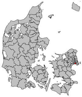
Hvidovre Kommune is a municipality in Region Hovedstaden near Copenhagen on the island of Zealand (Sjælland) in eastern Denmark. The municipality covers an area of 22 km², and has a total population of 53,416. Its mayor is Helle Moesgaard Adelborg, a member of the Social Democrats (Socialdemokraterne) political party.

Vesterbro, Copenhagen district of Copenhagen, Denmark

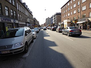
Vesterbro is one of the 15 administrative, statistical, and city tax districts (bydele) comprising the municipality of Copenhagen, Denmark. It covers an area of 3.76 km², and has a population of 51,466 and a population density of 13,688 per km².

Valby Idrætspark

Valby Idrætspark is a multi-purpose stadium in Valby od Copenhagen, Denmark. It is currently used mostly for football matches and is the home ground of Boldklubben Frem. Valby Idrætspark has hosted a total of nine Danish FA-recognized internationals.

Taastrup Place in Capital, Denmark

Taastrup is a Danish railway town or/and suburb of Copenhagen - 15 km west of the capital's city centre, and formerly the administrative seat of Høje-Taastrup Municipality, Region Hovedstaden. It takes its name from the village of Taastrup Valby, which also gave its name to the station established in 1859, from which the town grew. The population on 1 January 2014 was 33,121. It forms a twin (sub)urban area with neighbouring suburb Høje Taastrup since the 1980s, that has engulfed the villages of Taastrup Valby, Høje Taastrup, Kragehave and Klovtofte. This area has almost grown together with the town of Hedehusene.

Gudmund Nyeland Brandt was a Danish landscape architect who was internationally renowned.

Tap E

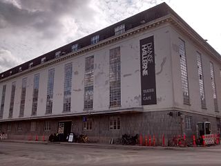
Tap E is a former storage building of a bottling plant in the Vesterbro district of Copenhagen, Denmark, part of Carlsberg's historic brewery site which is now known simply as the Carlsberg area. After the production of beer in the area stopped in 2009, the listed building has been taken unto use as a cultural venue which houses both a centre for modern dance, Dansehallerne, and Fotografisk Center, a gallery and digital laboratory dedicated to fine art photography.

Utterslev

Utterslev is a neighbourhood in the Bispebjerg district of Copenhagen, Denmark. Ut is centered on Utterslev Torv and is most known for the Utterslev Mose marshland which straddles the border with Gladsaxe Municipality to the north.

Brønshøj Rytterskole

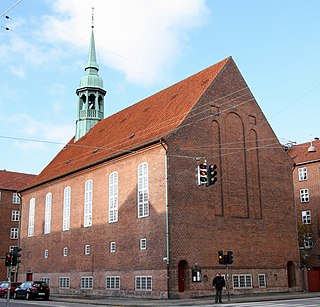
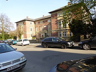
Brønshøj Rytterskole is a listed building on Brønshøj Torv in the Brønshøj-Husum distyrict of Copenhagen, Denmark. It is owned by Copenhagen Municipality and used as a venue for local cultural events and meetings.

H. C. Ørsteds Vej street in Frederiksberg Municipality, Denmark

H. C. Ørsteds Vej is a street in the Frederiksberg district of Copenhagen, Denmark. It runs from Åboulevard on the border with Nørrebro in the north to Gammel Kongevej in the south, linking Griffenfeldsgade with Alhambravej and further south Enghavevej-Kingogade with Griffenfeldsgade.

Thomas Havning Danish architect

Thomas Laub Hansen Havning was a Danish architect, illustrator, writer and royal building inspector born in Nyboder, Copenhagen on 4 September 1897.

Frederiksberg Åndsvageanstalt hospital

Frederiksberg Åndsvageanstalt is a former mental health treating institution for children located on Rahbeks Allé in the Frederiksberg district of Copenhagen, Denmark. It was founded in 1855 and moved to Ebberød in Birkerød in 1970. Its old main building from 1860 was designed by Gerdinand Meldahl and is listed. It now houses the cloathing brand By Malene Birger. Another building has been converted into a daycare. The buildings are located adjacent to the former Carlsberg brewery site which is under redevelopment into a new, dense neighbourhood.

Valby Langgade street in Copenhagen

Valby Langgade is one of the main streets of the Valby district of Copenhagen, Denmark. The circa 3.2 km long street runs from the southern end of Pile Allé and the Carlsberg neighbourhood in the east to Roskildevej at Damhus Lake in the west. The square and side street Valby Tingsted was the centre of the original village of Valby.

Carl Jacobsens Vej street in Copenhagen

Carl Jacobsens Vej is a street in the Valby district of Copenhagen, Denmark. It runs from Sjælør Boulevard on the rear side of Vestre Cemetery in the east to Gammel Køge Landevej in the wast. The street is lined by a mixture of converted industrial complexes from the beginning of the 20th century, building society developments and modern apartment buildings from the 2010s.

Toftegårds Plads

Toftegårds Plads is the largest square in the Valby district of Copenhagen, Denmark. It is bisected by Vigerslev Allé and situated on the corner with Gammel Køge Landevej.

White Houses, Valby

The White Houses in Valby, also known as Trekanten, is one of several developments of building society houses in the Valby district of Copenhagen, Denmark. The houses were built 1899–1903 and are located on the south side of Valby Langgade and the streets Søndre Allé, Nordre Allé and Østre Allé.

Howitzvej street in Frederiksberg Municipality, Denmark

Howitzvej is a street in the Frederiksberg district of Copenhagen, Denmark. It runs from Falkoner Allé in the east to Nordre Fasanvej where it turns into Finsensvej before the name changes again to Jernbane Allé on the border with Vanløse.

Frederiksberg Kommunale Funktionærers Boligforening

Frederiksberg Kommunale Funktionærers Boligforening, also known as Frederiksberg Haveby or Ved Grænsen, is an area of building society houses located off Finsensvej in Frederiksberg Municipality, Copenhagen, Denmark, on the border with Vanløse.

References

  1. "De første 100 år i Lyset" (PDF). Grundejerforeningen Lyset. Retrieved 2012-09-14.

Coordinates: 55°39′44″N12°30′14″E / 55.6622°N 12.5039°E / 55.6622; 12.5039

Geographic coordinate system Coordinate system

A geographic coordinate system is a coordinate system that enables every location on Earth to be specified by a set of numbers, letters or symbols. The coordinates are often chosen such that one of the numbers represents a vertical position and two or three of the numbers represent a horizontal position; alternatively, a geographic position may be expressed in a combined three-dimensional Cartesian vector. A common choice of coordinates is latitude, longitude and elevation. To specify a location on a plane requires a map projection.