
Taylor County is a county located in the U.S. state of Texas. As of the 2020 census, its population was 143,208. Its county seat is Abilene. The county was created in 1858 and later organized in 1878. It is named for Edward Taylor, George Taylor, and James Taylor, three brothers who died at the Battle of the Alamo.

The Gulf Intracoastal Waterway (GIWW) is the portion of the Intracoastal Waterway located along the Gulf Coast of the United States. It is a navigable inland waterway running approximately 1,300 mi (2,100 km) from Saint Marks, Florida, to Brownsville, Texas.
Somerville Lake is a U.S. Army Corps of Engineers reservoir on Yegua Creek in the Brazos River basin, 10 miles (16 km) northwest of Brenham, Texas, United States. The town of Somerville in Burleson County is adjacent to the reservoir. The lake extends into portions of Burleson County, Washington County, and Lee County. The dam lies in Washington County. The dam and lake are managed by the Fort Worth District of the U.S. Army Corps of Engineers. The reservoir was officially impounded in 1967, and serves to provide flood control and water for irrigation for the communities downstream. Somerville Lake is a popular recreational destination.

Table Rock Lake is an artificial lake or reservoir in the Ozarks of southwestern Missouri and northwestern Arkansas in the United States. Designed, built and operated by the U.S. Army Corps of Engineers, the lake is impounded by Table Rock Dam, which was constructed from 1954 to 1958 on the White River.

Jennings Randolph Lake is a reservoir of 952 acres (3.85 km2) located on the North Branch Potomac River in Garrett County, Maryland and Mineral County, West Virginia. It is approximately 8 miles (13 km) upstream of Bloomington, Maryland, and approximately 5 miles (8.0 km) north of Elk Garden, West Virginia.
Sam Rayburn Reservoir is a reservoir in the United States in Deep East Texas, 70 miles (110 km) north of Beaumont. The reservoir is fed by the Angelina River, the major tributary of the Neches River. The Reservoir is upstream of the Big Thicket National Preserve.

The Harry S Truman Reservoir, also known as Truman Lake, is located in the state of Missouri, United States. It is located between Clinton and Warsaw, on the Osage River and extends south to Osceola. The dam is located in Benton County, but the reservoir also extends into parts of Henry, St. Clair, and Hickory counties.
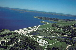
Lake Whitney is a flood control reservoir on the main stem of the Brazos River in Texas. It is located on River Mile Marker 442 and controls drainage for 17,656 square miles (45,730 km2) of Texas and parts of New Mexico. The reservoir encompasses a surface area of more than 23,500 acres and 225 miles (362 km) of shoreline. The area consists of rolling, tallgrass prairies; cedar trees; hardwood timber; and 100 ft (30 m) bluffs and rock points. Lake Whitney is also part of the Texas Lakes Trail Region of North Texas.

Canyon Lake is a reservoir on the Guadalupe River in the Texas Hill Country in the United States. Canyon Lake is a U.S. Army Corps of Engineers reservoir formed on the Guadalupe River in Comal County by Canyon Dam, which is located about sixteen miles northwest of New Braunfels. The dam, lake, and all adjacent property are managed by the U.S. Army Corps Of Engineers. Water rights, waste water treatment, and hydroelectric generating facilities are managed by the Guadalupe-Blanco River Authority. Construction of the dam began in 1958 and was completed in 1964. The reservoir serves to provide flood control and water supply for the communities downstream from the dam. The lake is also a popular recreational destination.

Belton Lake is a U.S. Army Corps of Engineers reservoir on the Leon River in the Brazos River basin, 5 miles (8 km) northwest of Belton, Texas, United States. The lake extends into both Bell County and Coryell County. Belton Dam and the lake are both managed by the Fort Worth District of the U.S. Army Corps of Engineers. The reservoir was officially impounded in 1954, and serves to provide flood control and drinking water for Belton, Temple, and the surrounding communities. Belton Lake is a popular recreational destination.
Proctor Lake is a U.S. Army Corps of Engineers reservoir along the Leon River located in Comanche County in the U.S. state of Texas, around 3 miles (5 km) west of Proctor, Texas. Proctor Lake Dam and the reservoir are managed by the Fort Worth District of the U.S. Army Corps of Engineers. The reservoir was officially impounded in 1963, and serves to provide flood control and drinking water for the communities downstream. Proctor Lake is a popular recreational destination.

Wright Patman Lake is a reservoir in northeast Texas in the United States. The lake is a U.S. Army Corps of Engineers reservoir formed on the Sulphur River in Bowie and Cass counties by Wright Patman Dam. The reservoir provides flood control and water conservation for the communities downstream from the dam. The lake is also a popular recreational destination. The Bowie County side of the lake is part of the Texarkana metropolitan area.

Lavon Lake is a freshwater reservoir located in southeast Collin County, Texas, on the East Fork of the Trinity River near Wylie, off State Highway 78. It is commonly called Lake Lavon for commercial and recreational purposes, but Lavon Lake is its official name according to the U.S. Army Corps of Engineers. It was originally called Lavon Reservoir.

Fern Ridge Reservoir is a reservoir on the Long Tom River in the U.S. state of Oregon. The reservoir is located approximately 12 miles (19 km) west of Eugene on Oregon Route 126. The reservoir is a U.S. Army Corps of Engineers flood control project encompassing more than 12,000 acres (49 km2) and is a popular site for boating, fishing, and birdwatching.

Lake O’ the Pines is a reservoir on Big Cypress Bayou, also known as Big Cypress Creek, chiefly in Marion County, Texas, United States. The reservoir also occupies a small part of Camp, Upshur, and Morris Counties. The dam is located approximately 8.5 miles (13.7 km) west of Jefferson.

Terminus Dam is a dam on the Kaweah River in Tulare County, California in the United States, located near Three Rivers about 15 mi (24 km) from the western boundary of Sequoia National Park and 20 mi (32 km) east of Visalia. The dam forms Lake Kaweah for flood control and irrigation water supply. Completed by the U.S. Army Corps of Engineers (USACE) in 1962, Terminus is an earthfill dam 255 ft (78 m) high and 2,375 ft (724 m) long. The reservoir has a maximum capacity of 185,600 acre⋅ft (0.2289 km3) of water, although it usually sits at much lower levels.

Coralville Lake is an artificial lake in Johnson County, Iowa, United States, formed by the Coralville Dam, a dam built from 1949 to 1958 on the Iowa River upstream from the city of Coralville, Iowa.

Abiquiu Dam is a dam on the Rio Chama, located about 60 miles (97 km) northwest of Santa Fe in Rio Arriba County, New Mexico, USA. Built and operated by the U.S. Army Corps of Engineers (USACE), the dam is an earth embankment structure 354 feet (108 m) high and 1,800 feet (550 m) long, containing 11.8 million cubic yards of fill. The dam forms Abiquiu Lake, one of the largest lakes in New Mexico, with a full storage capacity of 1,369,000 acre-feet (1,689,000 dam3) and 5,200 acres (2,100 ha) of water. To date, the reservoir has never filled to capacity, with a record high of 402,258 acre-feet (496,178 dam3), 29.4% of full pool, on June 22, 1987. The dam's primary purpose is flood control, in addition to irrigation and municipal water storage, and hydroelectric generation.
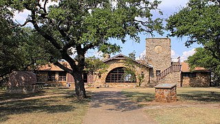
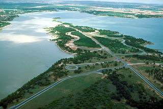
Lake Brownwood State Park is a state park located on the shore of Lake Brownwood in Brown County, Texas, United States and is administered by the Texas Parks and Wildlife Department. The 537.5 acre park was acquired by deed from the Brown County Water Improvement District No. 1 in 1933. The Civilian Conservation Corps (CCC) developed the park between 1934 and 1942. The park opened in 1938.

