Greenwich Village often referred to by locals as simply "the Village", is a neighborhood on the west side of Manhattan, New York City, within Lower Manhattan. Broadly, Greenwich Village is bounded by 14th Street to the north, Broadway to the east, Houston Street to the south, and the Hudson River to the west. Greenwich Village also contains several subsections, including the West Village west of Seventh Avenue and the Meatpacking District in the northwest corner of Greenwich Village.

Hoffman Estates is a village in Illinois, United States. The village is located primarily in Cook County, with a small section in Kane County. It is a suburb of Chicago. As of the 2010 census, the population was 51,895, and as of 2017 the estimated population was 51,567.

Algonquin is a village in McHenry and Kane counties, Illinois, in the United States. It is a suburb of Chicago, located approximately 40 miles (64 km) northwest of the Loop. As of the 2010 census the village's population was 30,046, and as of 2017 the estimated population was 31,017.

East Aurora is a village in Erie County, New York, United States, southeast of Buffalo. It lies in the eastern half of the town of Aurora. The village population was 6,236 at the 2010 census. It is part of the Buffalo–Niagara Falls Metropolitan Statistical Area. In 2015, East Aurora was rated the third-best town to raise a family in New York State by Niche.. According to the National Council of Home Safety and Security, it is also among the safest places to live in New York State.

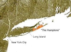
The Hamptons, part of the East End of Long Island, comprise a group of villages and hamlets in the towns of Southampton and East Hampton, which together form the South Fork of Long Island, in Suffolk County, New York. The Hamptons form a popular seaside resort and one of the historical summer colonies of the northeastern United States.

The East Village is a neighborhood in the New York City borough of Manhattan. It is roughly defined as the neighborhood east of the Bowery and Third Avenue, between 14th Street on the north and Houston Street on the south.

The Lower East Side, sometimes abbreviated as LES, is a neighborhood in the southeastern part of the New York City borough of Manhattan, roughly located between the Bowery and the East River, and Canal Street and Houston Street. Traditionally an immigrant, working class neighborhood, it began rapid gentrification in the mid-2000s, prompting the National Trust for Historic Preservation to place the neighborhood on their list of America's Most Endangered Places.
The R683 road is a regional road in Ireland. Located in the south of Ireland at Waterford, it connects the city to the village of Passage East, County Waterford and to County Wexford via a car ferry connection, which operates across the Waterford estuary between Passage East and the village of Ballyhack, County Wexford.
Badli is one of the oldest villages in Delhi. In old times it was one of the richest village in Delhi. History says that whenever Delhi was attacked Badli used to face the attack and used to be the camp of the invaders. AJESH YADAV is the MLA of Badli. Once famous for lush green crops this village today has good environment for living.Most of the villagers have their source of income from rent.Godowns and rooms made by landlords have made the village environment for peace living.

Aisy-sous-Thil is a commune in the Côte-d'Or department in the Bourgogne region of eastern France.

Aiserey is a commune in the Côte-d'Or department in the Bourgogne-Franche-Comté region of eastern France.

Barenton-sur-Serre is a commune in the department of Aisne in the Hauts-de-France region of northern France.

Bassoles-Aulers is a commune in the department of Aisne in the Hauts-de-France region of northern France.
Kalabhavi is a village in Belgaum district in Karnataka, India.
Midakanatti is a small village in the Gokak Taluk and Belagavi District of Karnataka State in India. It is administered by the Midakanatti Panchayat. It is located 33 km east of the divisional headquarters in Belagavi, 18 km from the town of Gokak, and 452 km from the state capital, Bengaluru.

Following the Syrian Arab Army's successful Kuweires offensive, during the Syrian Civil War, which ended with the securing of the Kuweires Military Airbase on 16 November 2015, the Syrian Army launched a new offensive in the eastern countryside of the Aleppo Governorate, with the aim of expanding the buffer zone around the airbase and disrupting ISIL supply lines.
The Rif Dimashq offensive was a Syrian Army offensive in the Rif Dimashq Governorate, that was launched in late April 2016, as part of the Syrian Civil War. The offensive resulted in the military's capture of the southern section of the rebel-held East Ghouta, as government forces exploited concurrent large-scale rebel infighting in East Ghouta that left around 500 rebels dead.

The East Aleppo offensive (2017), also referred to as the Dayr Hafir offensive (2017), was an operation launched by the Syrian Army to prevent Turkish-backed rebel forces from advancing deeper into Syria, and also to ultimately capture the ISIL stronghold of Dayr Hafir. Another aim of the operation was to gain control of the water source for Aleppo city, at the Khafsa Water Treatment Plant, in addition to capturing the Jirah Military Airbase. At the same time, the Turkish-backed rebel groups turned towards the east and started launching attacks against the Syrian Democratic Forces, west of Manbij.

The Maskanah Plains offensive was an operation by the Syrian Army against the remaining Islamic State of Iraq and the Levant (ISIL) strongholds in the eastern countryside of the Aleppo Province, with the goal of recapturing the Maskanah Plains from ISIL and advancing into the Raqqa Governorate.


