
Pennsylvania Avenue is a diagonal street in Washington, D.C. and Prince George's County, Maryland that connects the White House and the United States Capitol and then crosses the city to Maryland. In Maryland it is also Maryland Route 4 to MD 717 in Upper Marlboro, where it becomes Stephanie Roper Highway. The section between the White House and Congress is called "America's Main Street"; it is the location of official parades and processions, as well as protest marches. Moreover, Pennsylvania Avenue is an important commuter road and is part of the National Highway System.

Washington, D.C., formally the District of Columbia and also known as D.C. or just Washington, is the capital city of the United States of America. It is located on the Potomac River bordering Maryland and Virginia, with Congress holding its first session there in 1800. The city was named for George Washington, the first president of the United States and a Founding Father, and the federal district is named after Columbia, a female personification of the nation. As the seat of the U.S. federal government and several international organizations, the city is an important world political capital. It is one of the most visited cities in the U.S., with over 20 million visitors in 2016.

Georgetown is a historic neighborhood and a commercial and entertainment district located in northwest Washington, D.C., situated along the Potomac River. Founded in 1751 in the Province of Maryland, the port of Georgetown predated the establishment of the federal district and the City of Washington by 40 years. Georgetown remained a separate municipality until 1871 when the United States Congress created a new consolidated government for the whole District of Columbia. A separate act passed in 1895 specifically repealed Georgetown's remaining local ordinances and renamed Georgetown's streets to conform with those in the City of Washington.

The Bureau of Engraving and Printing (BEP) is a government agency within the United States Department of the Treasury that designs and produces a variety of security products for the United States government, most notable of which is Federal Reserve Notes for the Federal Reserve, the nation's central bank. In addition to paper currency, the BEP produces Treasury securities; military commissions and award certificates; invitations and admission cards; and many different types of identification cards, forms, and other special security documents for a variety of government agencies. The BEP does not produce coins; all coinage is produced by the United States Mint. With production facilities in Washington, D.C., and Fort Worth, Texas, the Bureau of Engraving and Printing is the largest producer of government security documents in the United States.

Dupont Circle is a traffic circle, park, neighborhood, and historic district in Northwest Washington, D.C. The Dupont Circle neighborhood is bounded approximately by 16th Street NW to the east, 22nd Street NW to the west, M Street NW to the south, and Florida Avenue NW to the north. Much of the neighborhood is listed on the National Register of Historic Places. However, the local government Advisory Neighborhood Commission and the Dupont Circle Historic District have slightly different boundaries.

Logan Circle is a traffic circle park, neighborhood, and historic district in the Northwest quadrant of Washington, D.C. The primarily residential neighborhood includes two historic districts, properties listed on the National Register of Historic Places, and sites designated D.C. Historic Landmarks. Vermont Avenue NW, Rhode Island Avenue NW, 13th Street NW, and P Street NW meet at the circle. An equestrian statue of Major General John A. Logan stands at its center. It is the only major circle downtown that remains entirely residential.
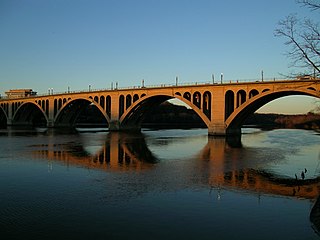
The Francis Scott Key Bridge, more commonly known as the Key Bridge, is a six-lane reinforced concrete arch bridge conveying U.S. Route 29 (US 29) traffic across the Potomac River between the Rosslyn neighborhood of Arlington County, Virginia, and the Georgetown neighborhood of Washington, D.C. Completed in 1923, it is Washington's oldest surviving road bridge across the Potomac River.
Constitution Avenue is a major east–west street in the northwest and northeast quadrants of the city of Washington, D.C., in the United States. It was originally known as B Street, and its western section was greatly lengthened and widened between 1925 and 1933. It received its current name on February 26, 1931, though it was almost named Jefferson Avenue in honor of Thomas Jefferson. Constitution Avenue's western half defines the northern border of the National Mall and extends from the United States Capitol to the Theodore Roosevelt Bridge. Its eastern half runs through the neighborhoods of Capitol Hill and Kingman Park before it terminates at Robert F. Kennedy Memorial Stadium. Many federal departmental headquarters, memorials, and museums line Constitution Avenue's western segment.

There are many outdoor sculptures in Washington, D.C. In addition to the capital's most famous monuments and memorials, many figures recognized as national heroes have been posthumously awarded with his or her own statue in a park or public square. Some figures appear on several statues: Abraham Lincoln, for example, has at least three likenesses, including those at the Lincoln Memorial, in Lincoln Park, and the old Superior Court of the District of Columbia. A number of international figures, such as Mohandas Gandhi, have also been immortalized with statues. The Statue of Freedom is a 19½-foot tall allegorical statue that rests atop the United States Capitol dome.
Mount Vernon Square is a city square and neighborhood in the Northwest quadrant of Washington, D.C. The square is located where the following streets would otherwise intersect: Massachusetts Avenue NW, New York Avenue NW, K Street NW, and 8th Street NW.

Massachusetts Avenue is a major diagonal transverse road in Washington, D.C., and the Massachusetts Avenue Historic District is a historic district that includes part of it.

Independence Avenue is a major east-west street in the southwest and southeast quadrants of the city of Washington, D.C., in the United States, running just south of the United States Capitol. Originally named South B Street, Independence Avenue SW was constructed between 1791 and 1823. Independence Avenue SE was constructed in pieces as residential development occurred east of the United States Capitol and east of the Anacostia River. Independence Avenue SW received its current name after Congress renamed the street in legislation approved on April 13, 1934. Independence Avenue SW originally had its western terminus at 14th Street SW, but was extended west to Ohio Drive SW between 1941 and 1942. The government of the District of Columbia renamed the portion of the road in the southeast quadrant of the city in 1950.
The name "M Street" refers to two major roads in the United States capital of Washington, D.C. Because of the Cartesian coordinate system used to name streets in Washington, the name "M Street" can be used to refer to any east-west street located twelve blocks north or south of the dome of the United States Capitol. Thus, in all four quadrants of the city there are streets called "M Street", which are disambiguated by quadrant designations, namely, M Street NW, NE, SW, and SE.
The streets and highways of Washington, D.C., form the core of the city's surface transportation infrastructure. Given that it is a planned city, streets in the capital of the United States follow a distinctive layout and addressing scheme. There are 1,500 miles (2,400 km) of public roads in the city, of which 1,392 miles (2,240 km) are owned and maintained by the district government.

Downtown is a neighborhood of Washington, D.C., as well as a colloquial name for the central business district in the northwest quadrant of the city. Historically, the Downtown has been defined as an area east of 16th Street NW, north of the National Mall/US Capitol complex, and south of Massachusetts Avenue, including the Penn Quarter. However, the city says that most residents, workers, and visitors think of Downtown in a broader sense—including areas as far north as Dupont Circle, the Golden Triangle, as far west as Foggy Bottom, and as far east as Capitol Hill. A small portion of this area is known as the Downtown Historic District and was listed on the NRHP in 2001.
U.S. Route 29 (US 29) in the District of Columbia is a U.S. highway which enters D.C. via Key Bridge from Arlington, Virginia, and exits at Silver Spring, Maryland. It predominantly follows city surface streets, although the portion of the route from Key Bridge east to 26th Street NW is an elevated highway. The elevated section of U.S. Route 29 in D.C. is better known as the Whitehurst Freeway. Called the city's most ridiculed bridge in 1989, there have been several attempts to have the Whitehurst Freeway torn down but cost and other considerations have stopped these proposals from being acted on.

The DC Streetcar is a surface streetcar network in Washington, D.C. As of 2017, it consists of only one line: a 2.2-mile segment running in mixed traffic along H Street and Benning Road in the city's Northeast quadrant.

The statue of John Aaron Rawlins, a United States Army general who served during the Civil War and later as Secretary of War, is a focal point of Rawlins Park, a small public park in Washington, D.C.'s Foggy Bottom neighborhood. It was installed in 1874, but relocated several times between 1880 and 1931. The statue was sculpted by French-American artist Joseph A. Bailly, whose best known work is the statue of George Washington in front of Independence Hall in Philadelphia.

Black Lives Matter Plaza is a two-block-long pedestrian section of 16th Street NW in Downtown Washington, D.C. The plaza was renamed by Mayor Muriel Bowser on June 5, 2020, after the Department of Public Works painted the words "Black Lives Matter" in 35-foot (11 m) yellow capital letters, along with the flag of Washington, D.C., as part of the George Floyd protests.