This article needs additional citations for verification .(February 2010) |
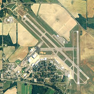
Machesney Airport( IATA : RMC) was a small rural airport located in Machesney Park, Illinois, United States.
This article needs additional citations for verification .(February 2010) |
Machesney Airport( IATA : RMC) was a small rural airport located in Machesney Park, Illinois, United States.
The airport was organized by Fred Machesney in 1927. The airfield was used during World War II by the US military as a stopover for fighter planes heading to the Soviet Union. [1] The airfield had a few buildings and a restaurant. Aircraft parked on the dirt and grass ramp and took off on a grass runway.
In the early 1960s, the airport offered flying lessons for $12 an hour, using circa 1939 Aeronca Champs as trainers. At least two of the instructors, Vince Block and Van Guilder, had been barnstormers, like the airport owner.
A tornado in 1966 damaged hangars and aircraft at the airport. [2]
After the Greater Rockford Airport opened, business at Machesney Airport declined, and it closed in 1974.
The name of the airport founder was used to name the new Machesney Park Village, formed within the bounds of what is still called North Park. After closing, the airport property was used to house the Machesney Park Mall.

Merrill C. Meigs Field Airport was a single-runway airport in Chicago that was in operation from 1948 to 2003, when it was bulldozed overnight by then-mayor Richard M. Daley. The airport was located on Northerly Island, an artificial peninsula on Lake Michigan adjacent to downtown Chicago, the second-largest business district in the Western Hemisphere. By 1955, Meigs Field had become the busiest single-strip airport in the United States. The airport was a familiar sight on the downtown lakefront. The latest air traffic tower was built in 1952, and the terminal was dedicated in 1961. The airfield was named for Merrill C. Meigs.

Beloit is a city in Rock County, Wisconsin, United States. As of the 2020 census, the city had a population of 36,657 people. Beloit is a principal city of the Janesville-Beloit Metropolitan Statistical Area and is included in the Madison Combined Statistical Area.

Winnebago County is a county located in the U.S. state of Illinois. According to the 2020 census, it had a population of 285,350 making it the seventh most populous county in Illinois behind Cook County and its five surrounding collar counties. Its county seat is Rockford. Winnebago County is the central county of the Rockford Metropolitan Statistical Area.

Loves Park is a city in Boone and Winnebago counties in the U.S. state of Illinois. Most of the city is in Winnebago County, with a tiny sliver in the east located in Boone County. The population was 23,397 at the 2020 census.

Machesney Park is a village located in Winnebago County, Illinois, United States. The population was 23,499 at the 2010 census, up from 20,759 in 2000. Machesney Park is part of the Rockford, Illinois Metropolitan Statistical Area.

Rockford is a city in Winnebago County, Illinois, United States. Located in the far northern part of the state on the banks of the Rock River, Rockford is the county seat of Winnebago County. The largest city in Illinois outside of the Chicago metropolitan area, Rockford is the fifth-most populous city in the state and the 171st-most populous in the United States. In the 2020 census, Rockford had a population of 148,655 anchoring the Greater Rockford Metropolitan Area with a population of 348,360.

Roscoe is a village in Winnebago County, Illinois, along the Rock River. It is in a suburban area of the Rockford, Illinois Metropolitan Statistical Area. As of the 2010 census, the village population was 10,785, up from 6,244 at the 2000 census. The area has been undergoing a period of rapid growth. There have been numerous border disputes with its neighbor to the west, Rockton, Illinois, and development and annexations continue by both villages. Recent growth has included the Promontory Ridge and Hidden Creek custom home subdivisions east of the Illinois Tollway, I-39/I-90.

The London International Airport is an international airport located in London, Ontario, Canada. It is located 5 nautical miles northeast of the city of London, Ontario and is classified as an airport of entry by Nav Canada. In 2011, the airport was listed as the 20th busiest airport in Canada in terms of aircraft movements with 94,747 travels. The airport posted a record 683,000 travelers in 2019 and 340,000 passengers in 2023. It provides services for cargo airlines and year-round flights with Air Canada Express and WestJet.
Barker Field was one of several airfields in the Yorkdale area of Toronto, Ontario, Canada.
Dothan Regional Airport is a public airport in Dale County, Alabama, United States, seven miles northwest of Dothan, a city mostly in Houston County.
Camp Grant was a U.S. Army facility located in the southern outskirts of Rockford, Illinois named in honor of American Civil War general Ulysses S. Grant. Camp Grant covered an area of 5,600 acres during World War I and 3,200 acres during World War II, and was in operation from 1917 to 1946.
Jumbolair Airport is a private-use airport. It is located in the unincorporated community of Anthony, which is seven miles (11 km) northeast of Ocala, Florida, United States. Frank Merschman owned and operated Jumbolair until 2019 when it was sold to Jumbolair Development LLC, managed by Robert and Debra Bull. The airport has two runways: 18/36 with an asphalt pavement measuring 7,550 x 210 ft and 9/27 with a grass surface measuring 3,640 x 100 ft. According to FAA documents, 9/27 ""Greystone"" grass airstrip was once so degraded that only the smallest aircraft could use it.
Christchurch Airfield was located southeast of the A337/B3059 intersection in Somerford, Christchurch, Dorset, England.

Aachen Merzbrück Airfield is an airfield located near Aachen, Germany.

Avon Park Executive Airport is a city-owned, public-use airport located two nautical miles (3.7 km) west of the central business district of Avon Park, a city in Highlands County, Florida, United States.
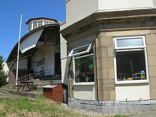
Stanley Park Aerodrome was an airfield located in the Stanley Park area of Blackpool, Lancashire, England. It was also known as Blackpool Municipal Airport, and was in use for civil and military flying from 1929 until closure of the airfield in 1947. The site is now used by Blackpool Zoo.

Truax Field Air National Guard Base, also known as Truax Field, is a military facility located at Dane County Regional Airport. It is located five miles (8 km) northeast of the center of Madison, a city in Dane County, Wisconsin, United States.
Machesney Park Mall was a shopping center in Machesney Park, Illinois, a village in the Rockford, Illinois metropolitan area. Since its opening, the mall has greatly declined. The entire enclosed portion of the mall was closed, with the south wing becoming retail space. Other parts of the mall have become retail space as well. A large portion of the mall was transformed into two separate stores, Burlington Coat Factory and Big Lots, in an effort to transform the mall into a shopping plaza.
Harlem High School is a public secondary school and part of the Harlem School District 122 in Machesney Park, Illinois, USA. It has approximately 2,600 students. The freshman campus for 9th grade was closed in 2019; new freshmen are incorporated into the main high school. Its sport teams are named the Harlem Huskies.

Naval Air Station Los Alamitos Naval Outlying Landing Fields were a set airfield near Naval Air Station Los Alamitos to support the training of US Navy pilots during World War 2. The support airfields are called Naval Outlying Landing Field (NOLF). For the war, many new trained pilots were needed. The Naval Outlying Landing Fields provided a place for pilots to practice landing and take off without other air traffic. The remotes sites offered flight training without distractions. Most of the new pilots departed to the Pacific War after training. The Outlying Landing Fields had little or no support facilities. Naval Air Station Los Alamitos opened in 1942 and was transferred to the US Army in 1977 as Los Alamitos Army Airfield. Most of the Outlying fields closed in 1945, having completed the role of training new pilots. To open the needed Outlying Landing Fields quickly, the Navy took over local crop dusting and barnstorming airfields. Naval Air Station Los Alamitos was also called Los Alamitos Naval Reserve Air Base. During the war Marine Corps Air Station El Toro also used the outlying Landing Field. The Timm N2T Tutor was the most common plane used for training on the outlying landing fields.
42°20′59.77″N089°3′11.2″W / 42.3499361°N 89.053111°W
| | This article about an airport in Illinois is a stub. You can help Wikipedia by expanding it. |